40014988 style essentials 1 location 1 piece powerpoint presentation diagram infographic slide
Be it for educational purposes or business, our World Map Of Continents And Seas PowerPoint Presentation Slide proves to be the best choice for every unique need and requirement. This PPT template consists of all the accurate information designed by our professionals. This PPT slide will help you create a data-driven business strategy. You can clearly display and demarcate each sea, ocean, and continent by taking the aid of our content-ready PPT layout. Select our PPT theme to visually represent the locations and geographics and grab the attention of the audience. Identify the target market and audience by employing this PPT visual. Educational institutions and students can take advantage of this PPT graphic for learning and teaching purposes. Our world map PPT design is an important tool for your research purposes. Click the download button and make this well-curated PowerPoint your source to examine the entire world map easily and accurately.
Be it for educational purposes or business, our World Map Of Continents And Seas PowerPoint Presentation Slide proves to be..
- Google Slides is a new FREE Presentation software from Google.
- All our content is 100% compatible with Google Slides.
- Just download our designs, and upload them to Google Slides and they will work automatically.
- Amaze your audience with SlideTeam and Google Slides.
-
Want Changes to This PPT Slide? Check out our Presentation Design Services
- WideScreen Aspect ratio is becoming a very popular format. When you download this product, the downloaded ZIP will contain this product in both standard and widescreen format.
-

- Some older products that we have may only be in standard format, but they can easily be converted to widescreen.
- To do this, please open the SlideTeam product in Powerpoint, and go to
- Design ( On the top bar) -> Page Setup -> and select "On-screen Show (16:9)” in the drop down for "Slides Sized for".
- The slide or theme will change to widescreen, and all graphics will adjust automatically. You can similarly convert our content to any other desired screen aspect ratio.
Compatible With Google Slides

Get This In WideScreen
You must be logged in to download this presentation.
PowerPoint presentation slides
Presenting our World Map Of Continents And Seas PowerPoint Presentation Slide. The template is fully editable in PowerPoint and compatible with Google Slides as well. You can adapt the slideshow according to your unique business requirements. Add your text, image, or icon with ease. The template can be converted into different formats such as JPG, PDF, etc. without any hassle. High-quality graphics ensure an attention-grabbing presentation. Additionally, it is available in both 4:3 and 16:9 aspect ratios.
Content of this Powerpoint Presentation
There was a time when people depended solely on physical maps for directions, shapes and sizes of countries, features and distance between places. Over time, digitalization made inroads in all spheres of life and even in the representation of maps. Nonetheless, its importance cannot be understated. Throughout history, mankind had relied on maps to negotiate life and create waves of progress for businesses.
So much so that when Kofi Annan, former UN general secretary, said, said “Knowledge is power. Information is liberating”, he must be talking about maps because maps have provided us with information and knowledge we need to make decisions.
The World Map with Continents and sea helps in understanding the Earth's surface layout. It assists sailors, pilots and travelers in planning routes and comprehending the layout of water bodies and land masses.
It also helps in studying weather patterns, climate change and ocean currents.
This PowerPoint Slide, curated by SlideTeam professionals, is 100% editable and customizable. You can change the color, size and the orientation of any element or text.
Let’s explore.
Template: World Map of Continents and Seas
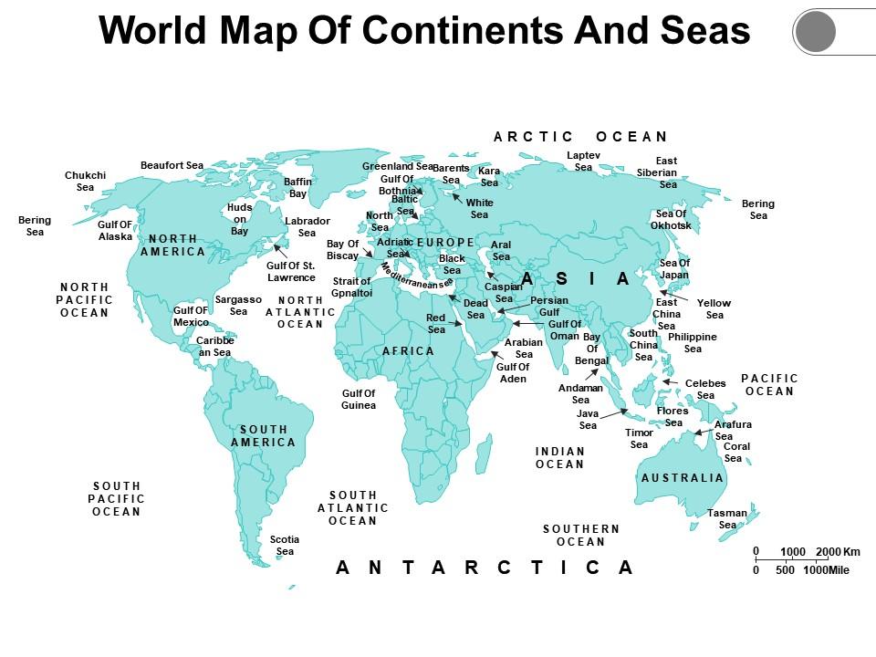
This Template is a reference to highlight landforms, waterbodies, position of cities, etc. It can be used for educational purposes in schools or universities, for any business strategy or for military purposes. It is a great addition to any geography lesson which makes learning fun for the student and helps in retention. There are additional slides in this template which comprises instructions to edit the slide, resize shade, edit color and use icons.
Explore Beyond Borders
This World Map is a reference for geopolitical analysis which aids in understanding international relations and boundaries. It can be used in urban planning, global trade routes, shipping lanes and infrastructure development. These advances in cartography and digital mapping technologies have enhanced accuracy and details of World maps.
40014988 style essentials 1 location 1 piece powerpoint presentation diagram infographic slide with all 5 slides:
Deliver the goods with our World Map Of Continents And Seas. Enhance your teams faith in you.
-
Very unique and reliable designs.
-
Great quality slides in rapid time.


