

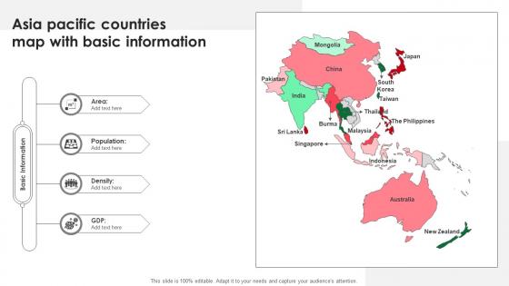
Asia Pacific Countries Map With Basic Information




Try Before you Buy Download Free Sample Product
 Impress Your
Audience
 100%
Editable
 Save Hours
of Time


Our Asia Pacific Countries Map With Basic Information are topically designed to provide an attractive backdrop to any subject. Use them to look like a presentation pro.
People who downloaded this PowerPoint presentation also viewed the following :
Asia Pacific Countries Map With Basic Information with all 9 slides:
Use our Asia Pacific Countries Map With Basic Information to effectively help you save your valuable time. They are readymade to fit into any presentation structure.







FAQs for Asia Pacific Countries Map
Looking at Asia Pacific maps, you'll spot the massive Himalayas and Andes cutting across continents. The Pacific and Indian Oceans dominate everything - honestly, the scale is wild when you see it all together. Indonesia and Philippines form these sprawling archipelagos, while major rivers like the Yangtze and Mekong snake through. Don't forget the Gobi Desert taking up huge chunks of land. That whole Ring of Fire thing around the Pacific is pretty intense with all the volcanic activity. Island nations are everywhere from Japan down to New Zealand. These features basically create natural trade routes and boundaries between countries, which is super helpful for any regional stuff you're working on.
Dude, Asia Pacific is like humanity's craziest cultural jigsaw puzzle. Papua New Guinea has 800+ indigenous languages just by itself - wild, right? Indonesia's spread across 17,000 islands with totally different ethnic groups on each one. Then you've got Singapore cramming Chinese, Malay, Tamil and English speakers into one tiny city-state. The language families are all over the place too - Sino-Tibetan, Austronesian, Papuan. It's basically thousands of years of people migrating and trading. Oh, and here's the kicker for business stuff: "Asia Pacific" isn't one market. You're dealing with dozens of completely separate cultural worlds.
So those shipping routes are huge for understanding who has power in Asia Pacific. The Strait of Malacca and South China Sea handle trillions in trade daily - countries literally fight over them because controlling the water means controlling the money flow. China's whole Belt and Road thing? That's them trying to build backup routes so they're not stuck depending on the usual pathways. Honestly feels like watching a massive strategy game play out. Oh, and definitely map those shipping lanes against territorial disputes when you're analyzing this stuff - the overlap is wild.
Honestly, just grab an Asia Pacific map and start plotting where you are now vs where you want to go. When I did this, seeing everything visually was such a game-changer - you'll spot patterns in spreadsheets that you'd totally miss otherwise. Look for countries clustered together with similar economies or trade deals. Singapore and Hong Kong jump out as obvious regional hubs that can hit multiple markets. Shipping routes become super clear too. Mark your top 3-5 targets first and see what story the geography tells you. Way better than boring country lists in presentations.
Colonial powers basically drew most of today's Asia Pacific borders - Britain, France, the Dutch, they just carved everything up however they wanted. Those weird straight lines you see? That's colonial admin boundaries right there. Then WWII happened and Japan's whole expansion/collapse thing totally reshuffled Korea and Taiwan. Honestly, the Cold War made everything worse by freezing all these messy borders in place. That's why we still have two Koreas and the whole Taiwan-China situation. Any current border drama in the region? Just trace it back to some colonial dude with a map and you'll find your answer.
Asia Pacific gets absolutely wrecked by climate change, honestly. Island nations like Tuvalu might just vanish underwater - wild to think about. Bangladesh is drowning in floods and cyclones, while Australia's bushfires keep getting worse. The Philippines? Those typhoons are brutal now. India and Southeast Asia are seeing their whole monsoon patterns shift, which screws with farming big time. Oh, and Australia's drought situation is pretty gnarly too. If you're doing any planning stuff in that region, you'd be crazy not to factor this in. It's literally reshaping how these countries operate.
So the big players you wanna know about are China, Japan, South Korea, Australia, and Singapore. China's the obvious beast here. Japan and South Korea crush it with their manufacturing - honestly their tech game is insane. Australia's sitting on tons of natural resources, which is nice for them lol. Singapore's tiny but somehow became this massive financial center. Don't forget India either - they're really coming up in tech and services lately. If you're thinking business opportunities, start with these countries for sure.
Honestly, the Asia Pacific is like a giant game of chess right now. China's pushing hard through the South China Sea, making all their neighbors super nervous. Taiwan's caught in the middle of this whole US-China thing, and don't even get me started on North Korea - they love stirring the pot with those missile tests. Those trade routes you see? They matter way more than people realize for global supply chains. If you're thinking business or just want to understand the risks, watch those hotspot areas closely. That's where things could blow up next. Pretty wild how interconnected it all is.
Dude, island nations basically run the show in Asia Pacific. They control the shipping lanes - we're talking 60% of global trade flowing through there. Indonesia's got the Malacca Strait locked down, Japan and Philippines are sitting pretty on the main Pacific routes. Plus their exclusive economic zones extend way past their actual borders, so they control fishing and underwater resources too. Australia and New Zealand hold down the south. Honestly, when you're looking at any trade or security stuff in the region, just check what the islands are doing first. They're usually calling the shots.
Honestly, it's all over the place depending on what map you're looking at. Australia, New Zealand, and Papua New Guinea usually show indigenous groups pretty clearly since they're bigger chunks of the population there. But in other spots? They might use special symbols or different colors, though smaller communities can disappear into the general demographic stuff - which is kind of annoying if you're actually trying to find that info. Scale matters a ton too. Your best move is finding maps that actually mention indigenous data in their legends or notes. Some cartographers are way better about this than others.
Honestly, good maps are game-changers for teaching Asia Pacific stuff. Students actually get the spatial relationships instead of just cramming country names. Those interactive digital ones are perfect - kids can zoom around, click for info, overlay trade routes or whatever. Color-coding helps too, like highlighting ASEAN countries together. The boring old textbook maps we grew up with? Forget those. You want maps showing connections - shipping lanes, cultural ties, economic zones. Oh, and get ones with layers they can toggle on and off. Makes it way more engaging than static borders.
Looking at that map, you've got these massive clusters along coastlines and rivers - that's where the money and trade routes are. Eastern China and Java? Huge markets but crazy competitive. Meanwhile places like Mongolia have tons of resources but good luck getting there easily. Those coastal megacities are goldmines for market access, though honestly the logistics of serving 20+ million people sounds like a nightmare. Australia's interior is basically empty compared to its coasts. If you're doing any regional planning, stick to those dense coastal areas but prepare for serious infrastructure headaches.
Asia Pacific environmental issues are all over the map, literally. Maldives and Tuvalu are basically drowning from rising seas. China and India? Total air pollution nightmares from all their factories. Australia's dealing with crazy bushfires and droughts - I swear it gets worse every year. Indonesia's chopping down forests like there's no tomorrow, while Japan stays busy prepping for the next tsunami or earthquake. Oh, and if you're planning any regional work, don't go with the same approach everywhere. Each country's problems are completely different.
Look, a good Asia Pacific map is perfect for finding those hidden gems before they blow up. You'll see how countries actually connect - way easier to plan multi-stop trips that aren't a logistical nightmare. Plus you can spot cool regional themes, like following the Mekong river through different countries or island-hopping the Pacific. Honestly, I had no idea how close some places were until I stopped relying on regular world maps. The real trick? Finding destinations that are accessible but haven't been completely overrun by tourists yet. Those are your goldmines.
Dude, just look at how weirdly straight some of those borders are - they totally ignore mountains, rivers, all the natural stuff. Myanmar, Malaysia, Indonesia? Those lines are where European colonizers literally just drew on maps based on their deals with each other. The Philippines is crazy obvious since it's exactly what Spain controlled, then the US took over. Honestly kind of blows my mind how much those old colonial boundaries still mess with politics today. Next time there's some regional conflict in the news, I bet it's happening right near one of those artificial borders.
-
Crisp and neat slides. Makes it fun and easier to curate presentations.
-
The information is visually stunning and easy to understand, making it perfect for any business person. So I would highly recommend you purchase this PPT design now!