


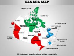
94259043 style essentials 1 location 1 piece powerpoint presentation diagram infographic slide





Try Before you Buy Download Free Sample Product
 Impress Your
Audience
 100%
Editable
 Save Hours
of Time


Our designers work around the clock to develop innovative Detailed Map Of Canada 1114. Agile designs for your presentation needs.
94259043 style essentials 1 location 1 piece powerpoint presentation diagram infographic slide with all 5 slides:
Get your team to brush up on the basics. School them with our Detailed Map Of Canada 1114.


FAQs for 94259043 style essentials 1 location 1 piece powerpoint presentation
Canada's key geographical regions include the Atlantic Provinces, Central Canada, the Prairie Provinces, British Columbia, and the Northern Territories. These regions showcase distinct economic opportunities and resource distributions, with the Prairies driving agricultural exports, Central Canada anchoring manufacturing and finance, and the territories offering mining potential, ultimately enabling strategic resource allocation and regional development planning.
Canada's provincial borders largely reflect historical treaties, colonial administrative decisions, and Confederation negotiations, with boundaries established through British territorial divisions, Indigenous treaty negotiations, and political compromises between founding provinces. These borders demonstrate how geographic features, resource rights, and diplomatic agreements shaped territorial organization, with provinces like Ontario and Quebec maintaining boundaries from pre-Confederation colonial territories, ultimately delivering administrative efficiency and regional governance structures.
Canada maps feature the Rocky Mountains, Great Lakes, Hudson Bay, Mackenzie River, Arctic Archipelago, and Niagara Falls as primary natural landmarks. These geographical features enable diverse industries from tourism to resource extraction, with regions like Alberta's oil sands and British Columbia's forestry sectors leveraging these natural assets for significant economic advantage.
Canada maps enhance classroom learning by illustrating geography, provincial boundaries, climate zones, natural resources, and population distribution through interactive lessons. Teachers utilize these visual tools for history discussions about confederation, indigenous territories, and economic development, while students engage in activities like capital identification and regional comparisons, ultimately developing stronger spatial awareness and Canadian cultural understanding.
Topographic maps of Canada play a crucial role in revealing elevation changes, terrain features, water systems, vegetation patterns, and geological formations across its vast territory. These detailed maps enable researchers, planners, and outdoor enthusiasts to analyze everything from Arctic tundra to coastal regions, ultimately delivering better resource management, infrastructure planning, and environmental conservation strategies for Canada's diverse ecosystems.
Canada maps increasingly incorporate indigenous territories through traditional territory acknowledgments, treaty boundaries, First Nations reserves, Métis settlements, and Inuit homeland designations. These enhanced cartographic representations enable organizations, educational institutions, and government agencies to better understand historical context, support reconciliation efforts, and facilitate respectful land use planning, ultimately delivering greater cultural awareness and improved indigenous relations across sectors.
Major cities on a Canada map include Toronto, Vancouver, Montreal, Calgary, Ottawa, Edmonton, and Winnipeg, each serving as regional economic powerhouses. These urban centers drive Canada's economy through diverse sectors, with Toronto leading financial services, Vancouver facilitating Pacific trade, Montreal anchoring aerospace manufacturing, and Calgary powering energy production, ultimately delivering regional specialization and competitive advantages across industries.
Canada maps are updated on varying schedules depending on the mapping organization and data type, with Statistics Canada updating demographic boundaries every five years following census data, while infrastructure changes are incorporated annually or biannually. These regular updates enable government agencies, businesses, and researchers to access current geographic information for strategic planning, resource allocation, and demographic analysis, ultimately delivering more accurate insights for decision-making across sectors.
**INPUT**: What tools or software are commonly used to create accurate Canada maps for presentations? **OUTPUT**: Popular Canada mapping tools include ArcGIS, QGIS, MapInfo, Google Earth Pro, and specialized presentation software like SlideTeam's templates. These platforms streamline cartographic workflows by offering precise geographic data, customizable provincial boundaries, and professional visualization features, with many organizations finding that integrated mapping solutions enhance stakeholder communication while reducing design time and ensuring geographic accuracy. [Word count: 58 words]
Climate zones in Canada vary dramatically from Arctic tundra in the north to temperate forests in the south, with continental, maritime, and subarctic regions creating distinct weather patterns, precipitation levels, and seasonal variations. These geographical differences enable businesses to strategically plan operations, with agriculture thriving in southern prairies, energy sectors leveraging northern resources, and tourism capitalizing on diverse seasonal offerings across provinces.
**INPUT**: What cultural landmarks are important to include on a Canada map for tourism purposes? **OUTPUT**: Important cultural landmarks for Canada tourism maps include CN Tower, Parliament Hill, Old Quebec City, Banff National Park, and Niagara Falls. These destinations enhance visitor experiences by showcasing diverse heritage, natural beauty, and architectural significance, with many tourism operators finding that featuring iconic landmarks alongside regional cultural sites ultimately delivers comprehensive travel planning and competitive advantage.
Canada maps illustrate climate change impact through shifting permafrost boundaries, retreating Arctic ice coverage, altered precipitation patterns, and changing vegetation zones across provinces. These geographic transformations enable environmental scientists, policymakers, and researchers to track northern ecosystem changes, assess infrastructure vulnerabilities, and develop adaptive strategies, ultimately delivering critical data for climate resilience planning nationwide.
Canada map symbols include political boundaries, topographic contours, transportation networks, population centers, natural features, and resource locations. These standardized legends enable users to identify provincial borders, elevation changes, highways and railways, urban areas, and geographical landmarks like rivers and mountains, ultimately delivering comprehensive spatial understanding for navigation, planning, and educational purposes across diverse applications.
Interactive Canada maps enhance user engagement by enabling real-time exploration, layered data visualization, customizable filtering, zoom capabilities, and clickable regional details. Through dynamic features like demographic overlays and economic indicators, organizations in tourism, education, and government sectors deliver more immersive experiences, while users retain geographic information more effectively, ultimately improving decision-making and spatial understanding.
Accurately representing Canada's vastness on a single map faces challenges including projection distortion, scale limitations, regional detail loss, geographic feature compression, and territorial proportion issues. These cartographic constraints require strategic choices between accuracy and readability, with many organizations finding that interactive digital maps or regional breakdowns deliver better spatial understanding and enhanced geographic comprehension for diverse audiences.
-
Really like the color and design of the presentation.
-
Great quality product.