

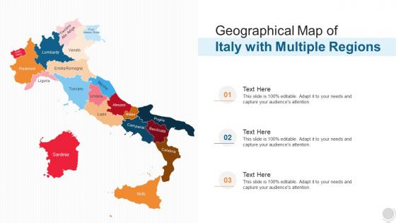
Geographical Map Of Italy With Multiple Regions




Try Before you Buy Download Free Sample Product
 Impress Your
 Audience
 100%
100% Editable
 Save Hours
 of Time


Our Geographical Map Of Italy With Multiple Regions are topically designed to provide an attractive backdrop to any subject. Use them to look like a presentation pro.
People who downloaded this PowerPoint presentation also viewed the following :
Geographical Map Of Italy With Multiple Regions with all 6 slides:
Use our Geographical Map Of Italy With Multiple Regions to effectively help you save your valuable time. They are readymade to fit into any presentation structure.





FAQs for Geographical Map Of Italy
Italy's regions are defined by distinctive geographical features including the Alpine mountain ranges in the north, the Apennine spine running through central areas, extensive coastlines along Mediterranean waters, volcanic formations, and fertile plains. These diverse landscapes enable regions like Lombardy to leverage Alpine resources for tourism and agriculture, while southern regions capitalize on coastal access for maritime industries, ultimately delivering varied economic advantages and strategic positioning across different sectors.
Italy's regional cultural identities reflect centuries of diverse historical influences, from Roman foundations and Byzantine rule in the south to Austrian governance in the north and maritime trade dominance in coastal areas. These historical layers manifest today through distinct dialects, culinary traditions, architectural styles, and local customs, with regions like Tuscany maintaining Renaissance artistic heritage while Sicily blends Mediterranean influences, ultimately creating Italy's rich cultural mosaic that enhances tourism appeal and regional economic specialization.
The Italy Regions Map serves as a crucial linguistic reference, illustrating how regional boundaries correspond with distinct dialects, minority languages like Sardinian and Friulian, and variations of Italian across the peninsula. This geographic framework enables linguists, educators, and cultural researchers to understand language distribution patterns, preserve regional linguistic heritage, and develop targeted educational programs, while helping businesses and tourism sectors navigate Italy's rich multilingual landscape more effectively.
The Italy Regions Map serves as a comprehensive educational tool for teaching Italian geography through regional identification, capital city locations, topographical features, and cultural distinctions across Italy's twenty regions. In classrooms, teachers utilize these maps for interactive lessons comparing northern industrial regions like Lombardy with southern agricultural areas such as Sicily, ultimately enhancing students' spatial awareness and cultural understanding of Italy's diverse geographical landscape.
Italy's regional economic strengths include Lombardy's finance and manufacturing, Veneto's textiles and machinery, Emilia-Romagna's automotive and food processing, Tuscany's luxury goods and tourism, and Lazio's services and government sectors. These diverse industrial clusters enable businesses to leverage regional specializations for supply chain optimization, market access, and strategic partnerships, with many multinational companies finding that Italy's economic geography delivers competitive advantages through specialized expertise and established industrial networks.
Wine production varies dramatically across Italy's regions, with northern areas like Piedmont and Veneto producing structured reds and crisp whites, central regions like Tuscany creating renowned Chianti and Brunello, and southern areas including Sicily focusing on robust varietals. The Italy Regions Map effectively illustrates these variations through color-coding and regional markers, enabling wine educators, distributors, and tourism professionals to visualize production zones, ultimately enhancing market strategies and consumer education.
Notable tourist attractions across Italy's regions include the Colosseum and Vatican City in Lazio, Venice's canals in Veneto, Florence's Renaissance art in Tuscany, the Amalfi Coast in Campania, and Sicily's ancient ruins. These landmarks enable tourism professionals and travel planners to create comprehensive itineraries by region, ultimately delivering enhanced visitor experiences and strategic route planning for Italy's diverse cultural heritage.
Italy's climate ranges from Mediterranean coastal conditions to alpine mountain weather, continental plains climates, and subtropical southern zones, varying significantly by latitude, altitude, and coastal proximity. These variations can be depicted through color-coded temperature zones, precipitation patterns, seasonal weather maps, and specialized overlays showing agricultural zones, with many businesses in tourism, agriculture, and logistics finding that visual climate mapping enhances operational planning and strategic decision-making.
Regional governments in Italy significantly influence local customs and traditions through cultural funding, festival regulation, language preservation policies, and heritage site management. These impacts can be mapped by documenting regional cultural initiatives, traditional celebration patterns, dialect preservation efforts, and artisan craft distributions, with regions like Sicily and Lombardy showcasing distinct governmental approaches to maintaining their unique cultural identities.
The Italy Regions Map assists in understanding migration patterns by visualizing population movements between northern industrial regions like Lombardy, southern agricultural areas such as Calabria, and central regions including Lazio. This geographical framework enables researchers, policymakers, and businesses to analyze demographic shifts, labor mobility, and economic opportunities, ultimately delivering strategic insights for urban planning and resource allocation across Italy's diverse regional landscape.
Italy's regional culinary specialties include Tuscany's Chianti wine and ribollita, Sicily's arancini and cannoli, Emilia-Romagna's Parmigiano-Reggiano and prosciutto di Parma, Campania's Neapolitan pizza and mozzarella di bufala, and Piedmont's truffles and Barolo wine. These distinctive specialties enhance cultural tourism experiences by showcasing authentic local flavors, traditional cooking methods, and artisanal food production, ultimately delivering immersive gastronomic journeys that attract culinary enthusiasts and boost regional tourism economies.
The Italy Regions Map aids in visualizing transportation networks by displaying major highways, rail lines, airports, and ferry routes connecting all twenty regions, while highlighting infrastructure density and accessibility patterns. Through comprehensive network mapping, businesses and logistics companies can identify optimal distribution routes, assess regional connectivity gaps, and streamline supply chain operations, ultimately delivering enhanced operational efficiency and strategic transportation planning across Italy's diverse geographic landscape.
Italy's regional population density map depicts variations through color coding, shading gradients, and statistical overlays that highlight concentrated urban areas versus sparse rural regions. The visualization typically shows northern industrial regions like Lombardy and Veneto with darker shading indicating higher density, while southern regions display lighter colors, with many organizations finding that these visual distinctions enable better resource allocation and strategic planning.
The Italy Regions Map serves as a strategic planning tool for businesses by identifying regional economic strengths, demographic concentrations, industrial clusters, and regulatory variations across Italy's diverse territories. Through visual analysis of regional characteristics, companies can optimize market entry strategies, target high-potential areas like Lombardy for manufacturing or Tuscany for luxury goods, and allocate resources efficiently, ultimately delivering competitive advantage in Italy's complex, regionally-distinct marketplace.
Italy's regional environmental concerns include Alpine glacial retreat in northern regions, coastal erosion along Mediterranean shores, volcanic emissions around Naples and Sicily, water scarcity in southern areas, and industrial pollution in Lombardy. These challenges can be illustrated through color-coded mapping, data overlays, and visual indicators that enable organizations to assess environmental risks, plan sustainable operations, and develop targeted mitigation strategies, ultimately delivering enhanced decision-making for businesses operating across Italy's diverse geographical landscape.
-
I discovered this website through a google search, the services matched my needs perfectly and the pricing was very reasonable. I was thrilled with the product and the customer service. I will definitely use their slides again for my presentations and recommend them to other colleagues.
-
Great product with highly impressive and engaging designs.