

Top 10 GIS Mapping PowerPoint Templates with Professional Designs
Save time and engage your audience with our fully editable PowerPoint PPT Templates and Slides.
-

GIS Mapping In Real Estate Projects PPT Information AT
Do not compromise on a template that erodes your messages impact. Introducing our engaging GIS Mapping In Real Estate Projects PPT Information AT complete deck, thoughtfully crafted to grab your audiences attention instantly. With this deck, effortlessly download and adjust elements, streamlining the customization process. Whether you are using Microsoft versions or Google Slides, it fits seamlessly into your workflow. Furthermore, it is accessible in JPG, JPEG, PNG, and PDF formats, facilitating easy sharing and editing. Not only that you also play with the color theme of your slides making it suitable as per your audiences preference.
-

GIS Mapping For Public Health PPT Guidelines AT
Ditch the Dull templates and opt for our engaging GIS Mapping For Public Health PPT Guidelines AT deck to attract your audience. Our visually striking design effortlessly combines creativity with functionality, ensuring your content shines through. Compatible with Microsoft versions and Google Slides, it offers seamless integration of presentation. Save time and effort with our pre-designed PPT layout, while still having the freedom to customize fonts, colors, and everything you ask for. With the ability to download in various formats like JPG, JPEG, and PNG, sharing your slides has never been easier. From boardroom meetings to client pitches, this deck can be the secret weapon to leaving a lasting impression.
-
GIS Mapping For Infrastructure Management PPT Outline AT
Do not compromise on a template that erodes your messages impact. Introducing our engaging GIS Mapping For Infrastructure Management PPT Outline AT complete deck, thoughtfully crafted to grab your audiences attention instantly. With this deck, effortlessly download and adjust elements, streamlining the customization process. Whether you are using Microsoft versions or Google Slides, it fits seamlessly into your workflow. Furthermore, it is accessible in JPG, JPEG, PNG, and PDF formats, facilitating easy sharing and editing. Not only that you also play with the color theme of your slides making it suitable as per your audiences preference.
-
GIS Mapping For Business Strategy PPT PowerPoint AT
Step up your game with our enchanting GIS Mapping For Business Strategy PPT PowerPoint AT deck, guaranteed to leave a lasting impression on your audience. Crafted with a perfect balance of simplicity, and innovation, our deck empowers you to alter it to your specific needs. You can also change the color theme of the slide to mold it to your companys specific needs. Save time with our ready-made design, compatible with Microsoft versions and Google Slides. Additionally, its available for download in various formats including JPG, JPEG, and PNG. Outshine your competitors with our fully editable and customized deck.
-
GIS Mapping Applications In Modern Agriculture PPT Sample AT
Do not compromise on a template that erodes your messages impact. Introducing our engaging GIS Mapping Applications In Modern Agriculture PPT Sample AT complete deck, thoughtfully crafted to grab your audiences attention instantly. With this deck, effortlessly download and adjust elements, streamlining the customization process. Whether you are using Microsoft versions or Google Slides, it fits seamlessly into your workflow. Furthermore, it is accessible in JPG, JPEG, PNG, and PDF formats, facilitating easy sharing and editing. Not only that you also play with the color theme of your slides making it suitable as per your audiences preference.
-
GIS Mapping Environmental Planning PPT Mockup VA
Somewhere between raw spatial data and a city council decision clarity gets lost. This presentation deck bridges that gap turning complex layers of land use and ecosystem analysis into visuals a room full of stakeholders can grasp in seconds. The GIS mapping environmental planning PPT mockup delivers geographic insight without the technical overwhelm letting you focus on policy outcomes rather than tool mechanics. Smartly organized editable slides accommodate demographic overlays flood risk assessments and green space initiatives all formatted for smooth integration into your consulting report. Every chart and diagram supports your narrative arc so your next zoning discussion feels like a guided tour not a data dump.
-
GIS Mapping Environmental Monitoring PPT Designs VA
Satellites trace the smoke plume across the valley while your ground sensors pulse with live data yet the boardroom still needs to see the whole story at a glance. That is where thoughtful GIS mapping environmental monitoring PPT designs turn raw coordinates into a decision ready narrative. These business slides pair crisp cartography with clean data visualization so every watershed shift and air quality spike becomes an argument your stakeholders can follow without squinting at legends. Built as editable slides for PowerPoint and Google Slides the creative layouts let you drop in your own shapefiles and sensor feeds without breaking the visual flow. Present the evidence with confidence not clutter.
-
Environmental GIS Mapping Strategies PPT PowerPoint AT
Do not compromise on a template that erodes your messages impact. Introducing our engaging Environmental GIS Mapping Strategies PPT PowerPoint AT complete deck, thoughtfully crafted to grab your audiences attention instantly. With this deck, effortlessly download and adjust elements, streamlining the customization process. Whether you are using Microsoft versions or Google Slides, it fits seamlessly into your workflow. Furthermore, it is accessible in JPG, JPEG, PNG, and PDF formats, facilitating easy sharing and editing. Not only that you also play with the color theme of your slides making it suitable as per your audiences preference.
-
GIS Mapping And Spatial Analysis Specialization PPT Outline AT
Ditch the Dull templates and opt for our engaging GIS Mapping And Spatial Analysis Specialization PPT Outline AT deck to attract your audience. Our visually striking design effortlessly combines creativity with functionality, ensuring your content shines through. Compatible with Microsoft versions and Google Slides, it offers seamless integration of presentation. Save time and effort with our pre-designed PPT layout, while still having the freedom to customize fonts, colors, and everything you ask for. With the ability to download in various formats like JPG, JPEG, and PNG, sharing your slides has never been easier. From boardroom meetings to client pitches, this deck can be the secret weapon to leaving a lasting impression.
-
GIS Mapping Environmental Analysis PPT Summary AT
Ditch the Dull templates and opt for our engaging GIS Mapping Environmental Analysis PPT Summary AT deck to attract your audience. Our visually striking design effortlessly combines creativity with functionality, ensuring your content shines through. Compatible with Microsoft versions and Google Slides, it offers seamless integration of presentation. Save time and effort with our pre-designed PPT layout, while still having the freedom to customize fonts, colors, and everything you ask for. With the ability to download in various formats like JPG, JPEG, and PNG, sharing your slides has never been easier. From boardroom meetings to client pitches, this deck can be the secret weapon to leaving a lasting impression.
-
GIS Mapping Techniques PPT Structure VA
Busy schedules leave little room for fumbling through cluttered slides especially when your audience needs to grasp spatial relationships quickly. This presentation structure turns raw geographic data into a clear guided narrative that flows logically from foundational concepts to advanced analysis. You will find ready to use slides for layering data showcasing overlays and explaining coordinate systems without drowning viewers in technical jargon. Each section supports visual storytelling with editable graphics that fit your specific project needs. Whether you present to planners stakeholders or students this deck helps you explain complex mapping workflows with confidence and clarity saving you hours of design work while keeping your message sharp and professional.
-
GIS Mapping Environmental Analysis PPT Example VA
Before the first fieldwork day even begins you need to convey complex spatial relationships to stakeholders who think in dollars and deadlines. This GIS Mapping Environmental Analysis presentation deck bridges the gap between raw geographic data and actionable environmental strategy. Instead of static spreadsheets your audience will experience visual storytelling through editable slides that transform Landsat imagery into compelling executive summaries. Whether you are tracking habitat corridors or modeling flood risk these business slides allow instant customization of color scales and legend keys for precise data visualization. From consulting presentation to boardroom briefing this keynote template keeps your narrative focused on impact not software mechanics. Professional PPT structure lets you spotlight critical findings clearly. Build a strategy deck that turns coordinates into decisive action today.
-
GIS Mapping Software Environmental Analysis PPT Outline VA
Every environmental initiative lives or dies by its spatial story and your next boardroom update needs to land that narrative hard. This GIS Mapping Software Environmental Analysis PPT outline transforms complex satellite data and terrain modeling into a clear compelling arc that decision makers can actually follow. You will guide stakeholders from raw geographic layers through critical impact assessments to actionable next steps using modern slide design and data visualization that make your methodology obvious. The structure helps you present biodiversity shifts resource usage and risk zones without losing your audience in technical jargon. Whether you need a consulting presentation or a strategy deck these editable slides adapt to your briefing needs. Save hours reworking charts and reclaim your time for the fieldwork that matters.
-
GIS Mapping For Disaster Risk PPT Demonstration AT
Do not compromise on a template that erodes your messages impact. Introducing our engaging GIS Mapping For Disaster Risk PPT Demonstration AT complete deck, thoughtfully crafted to grab your audiences attention instantly. With this deck, effortlessly download and adjust elements, streamlining the customization process. Whether you are using Microsoft versions or Google Slides, it fits seamlessly into your workflow. Furthermore, it is accessible in JPG, JPEG, PNG, and PDF formats, facilitating easy sharing and editing. Not only that you also play with the color theme of your slides making it suitable as per your audiences preference.
-
Accuracy Versus Precision In GIS Mapping Best Practices PPT Guidelines AT
While your presentation may contain top-notch content, if it lacks visual appeal, you are not fully engaging your audience. Introducing our Accuracy Versus Precision In GIS Mapping Best Practices PPT Guidelines AT deck, designed to engage your audience. Our complete deck boasts a seamless blend of Creativity and versatility. You can effortlessly customize elements and color schemes to align with your brand identity. Save precious time with our pre-designed template, compatible with Microsoft versions and Google Slides. Plus, its downloadable in multiple formats like JPG, JPEG, and PNG. Elevate your presentations and outshine your competitors effortlessly with our visually stunning 100 percent editable deck.
-
GIS Mapping For Urban Planning PPT Mockup AT
Step up your game with our enchanting GIS Mapping For Urban Planning PPT Mockup AT deck, guaranteed to leave a lasting impression on your audience. Crafted with a perfect balance of simplicity, and innovation, our deck empowers you to alter it to your specific needs. You can also change the color theme of the slide to mold it to your companys specific needs. Save time with our ready-made design, compatible with Microsoft versions and Google Slides. Additionally, its available for download in various formats including JPG, JPEG, and PNG. Outshine your competitors with our fully editable and customized deck.
-
GIS Mapping Tools Software And Hardware PPT Presentation AT
Step up your game with our enchanting GIS Mapping Tools Software And Hardware PPT Presentation AT deck, guaranteed to leave a lasting impression on your audience. Crafted with a perfect balance of simplicity, and innovation, our deck empowers you to alter it to your specific needs. You can also change the color theme of the slide to mold it to your companys specific needs. Save time with our ready-made design, compatible with Microsoft versions and Google Slides. Additionally, its available for download in various formats including JPG, JPEG, and PNG. Outshine your competitors with our fully editable and customized deck.
-
GIS Mapping Archaeological Fieldwork PPT Summary AT
Step up your game with our enchanting GIS Mapping Archaeological Fieldwork PPT Summary AT deck, guaranteed to leave a lasting impression on your audience. Crafted with a perfect balance of simplicity, and innovation, our deck empowers you to alter it to your specific needs. You can also change the color theme of the slide to mold it to your companys specific needs. Save time with our ready-made design, compatible with Microsoft versions and Google Slides. Additionally, its available for download in various formats including JPG, JPEG, and PNG. Outshine your competitors with our fully editable and customized deck.
-
GIS Mapping Satellite Data Analysis PPT Graphics VA
Aerial views only tell half the story until you overlay the layers that matter. This presentation bundle turns raw satellite feeds and geographic coordinates into a clear narrative for stakeholders who need decisions not data dumps. You get editable slides designed for visualizing land use environmental shifts and infrastructure patterns without wrestling with complex software. Each modern slide design works seamlessly in PowerPoint or Google Slides so your team can jump straight into visual storytelling. From field reports to boardroom briefs these presentation graphics help you translate remote sensing into actionable intelligence. Stop explaining your analysis with static maps and start showing the full picture with clarity and impact.
-
GIS Farm Mapping PPT Example VA
Every acre tells a story but only if you can see the patterns hidden within the soil. You need to translate complex land data into a clear vision for your next growing season or stakeholder review. This presentation deck turns raw satellite coordinates and yield reports into a visual narrative that agronomists and investors will instantly grasp. With editable slides and modern slide design you can plot field boundaries irrigation zones and crop health metrics without wrestling with confusing software. Stop explaining your data in dense spreadsheets and start showing it through polished PowerPoint templates that make precision agriculture feel intuitive. Your next field report deserves that clarity.
-
GIS For Pollution And Risk Mapping PPT Slides AT
Step up your game with our enchanting GIS For Pollution And Risk Mapping PPT Slides AT deck, guaranteed to leave a lasting impression on your audience. Crafted with a perfect balance of simplicity, and innovation, our deck empowers you to alter it to your specific needs. You can also change the color theme of the slide to mold it to your companys specific needs. Save time with our ready made design, compatible with Microsoft versions and Google Slides. Additionally, its available for download in various formats including JPG, JPEG, and PNG. Outshine your competitors with our fully editable and customized deck.
-
GIS Archaeology Mapping Ancient Sites PPT Sample AT
Do not compromise on a template that erodes your messages impact. Introducing our engaging GIS Archaeology Mapping Ancient Sites PPT Sample AT complete deck, thoughtfully crafted to grab your audiences attention instantly. With this deck, effortlessly download and adjust elements, streamlining the customization process. Whether you are using Microsoft versions or Google Slides, it fits seamlessly into your workflow. Furthermore, it is accessible in JPG, JPEG, PNG, and PDF formats, facilitating easy sharing and editing. Not only that you also play with the color theme of your slides making it suitable as per your audiences preference.
-
GIS Applications For Archaeological Mapping PPT Template AT
Do not compromise on a template that erodes your messages impact. Introducing our engaging GIS Applications For Archaeological Mapping PPT Template AT complete deck, thoughtfully crafted to grab your audiences attention instantly. With this deck, effortlessly download and adjust elements, streamlining the customization process. Whether you are using Microsoft versions or Google Slides, it fits seamlessly into your workflow. Furthermore, it is accessible in JPG, JPEG, PNG, and PDF formats, facilitating easy sharing and editing. Not only that you also play with the color theme of your slides making it suitable as per your audiences preference.
-
End To End Mobile Mapping Workflow From Data Capture To GIS PPT Information AT
While your presentation may contain top-notch content, if it lacks visual appeal, you are not fully engaging your audience. Introducing our End To End Mobile Mapping Workflow From Data Capture To GIS PPT Information AT deck, designed to engage your audience. Our complete deck boasts a seamless blend of Creativity and versatility. You can effortlessly customize elements and color schemes to align with your brand identity. Save precious time with our pre-designed template, compatible with Microsoft versions and Google Slides. Plus, its downloadable in multiple formats like JPG, JPEG, and PNG. Elevate your presentations and outshine your competitors effortlessly with our visually stunning 100 percent editable deck.
-
Gis Mapping And Spatial Analysis Specialization In Ppt Powerpoint Presentation Slide Templates Cpp
Presenting our Gis Mapping And Spatial Analysis Specialization In Ppt Powerpoint Presentation Slide Templates Cpp PowerPoint template design. This PowerPoint slide showcases six stages. It is useful to share insightful information on Gis Mapping And Spatial Analysis Specialization This PPT slide can be easily accessed in standard screen and widescreen aspect ratios. It is also available in various formats like PDF, PNG, and JPG. Not only this, the PowerPoint slideshow is completely editable and you can effortlessly modify the font size, font type, and shapes according to your wish. Our PPT layout is compatible with Google Slides as well, so download and edit it as per your knowledge.
-
Gis Mapping And Spatial Analysis In Ppt Powerpoint Presentation Slide Templates Cpp
Presenting our Gis Mapping And Spatial Analysis In Ppt Powerpoint Presentation Slide Templates Cpp PowerPoint template design. This PowerPoint slide showcases four stages. It is useful to share insightful information on Gis Mapping And Spatial Analysis This PPT slide can be easily accessed in standard screen and widescreen aspect ratios. It is also available in various formats like PDF, PNG, and JPG. Not only this, the PowerPoint slideshow is completely editable and you can effortlessly modify the font size, font type, and shapes according to your wish. Our PPT layout is compatible with Google Slides as well, so download and edit it as per your knowledge.
-
Drone Gis Mapping Monotone Icon In Powerpoint Pptx Png And Editable Eps Format
This Monotone Powerpoint Icon on Drone Mapping is perfect for presentations and reports. It features a modern, minimalistic design with a drone silhouette and a map in the background, conveying the idea of aerial mapping. It is easy to customize and comes in multiple sizes and formats.
-
Drone Gis Mapping Colored Icon In Powerpoint Pptx Png And Editable Eps Format
This colourful PowerPoint icon is the perfect visual representation of Drone Mapping. It features an aerial view of a drone in flight, and is perfect for any presentation related to mapping or aerial photography. Its a great way to bring your presentation to life and capture the attention of your audience.
-
Using GIS And AHP For Airport Location Suitability Mapping PPT Structure AT
Step up your game with our enchanting Using GIS And AHP For Airport Location Suitability Mapping PPT Structure AT deck, guaranteed to leave a lasting impression on your audience. Crafted with a perfect balance of simplicity, and innovation, our deck empowers you to alter it to your specific needs. You can also change the color theme of the slide to mold it to your companys specific needs. Save time with our ready-made design, compatible with Microsoft versions and Google Slides. Additionally, its available for download in various formats including JPG, JPEG, and PNG. Outshine your competitors with our fully editable and customized deck.
-
Incident Mapping With GIS Technology PPT PowerPoint AT
Do not compromise on a template that erodes your messages impact. Introducing our engaging Incident Mapping With GIS Technology PPT PowerPoint AT complete deck, thoughtfully crafted to grab your audiences attention instantly. With this deck, effortlessly download and adjust elements, streamlining the customization process. Whether you are using Microsoft versions or Google Slides, it fits seamlessly into your workflow. Furthermore, it is accessible in JPG, JPEG, PNG, and PDF formats, facilitating easy sharing and editing. Not only that you also play with the color theme of your slides making it suitable as per your audiences preference.
-
Mapping Crop Health And Nutrient Distribution With GIS PPT Slides AT
While your presentation may contain top-notch content, if it lacks visual appeal, you are not fully engaging your audience. Introducing our Mapping Crop Health And Nutrient Distribution With GIS PPT Slides AT deck, designed to engage your audience. Our complete deck boasts a seamless blend of Creativity and versatility. You can effortlessly customize elements and color schemes to align with your brand identity. Save precious time with our pre-designed template, compatible with Microsoft versions and Google Slides. Plus, its downloadable in multiple formats like JPG, JPEG, and PNG. Elevate your presentations and outshine your competitors effortlessly with our visually stunning 100 percent editable deck.
-
Mapping Techniques Applying Grids And Graticules In GIS PPT Template AT
Step up your game with our enchanting Mapping Techniques Applying Grids And Graticules In GIS PPT Template AT deck, guaranteed to leave a lasting impression on your audience. Crafted with a perfect balance of simplicity, and innovation, our deck empowers you to alter it to your specific needs. You can also change the color theme of the slide to mold it to your companys specific needs. Save time with our ready-made design, compatible with Microsoft versions and Google Slides. Additionally, its available for download in various formats including JPG, JPEG, and PNG. Outshine your competitors with our fully editable and customized deck.
-
Leveraging Drones And GIS For Effective Crisis Mapping PPT Outline ACP
While your presentation may contain top-notch content, if it lacks visual appeal, you are not fully engaging your audience. Introducing our Leveraging Drones And GIS For Effective Crisis Mapping PPT Outline ACP deck, designed to engage your audience. Our complete deck boasts a seamless blend of Creativity and versatility. You can effortlessly customize elements and color schemes to align with your brand identity. Save precious time with our pre-designed template, compatible with Microsoft versions and Google Slides. Plus, its downloadable in multiple formats like JPG, JPEG, and PNG. Elevate your presentations and outshine your competitors effortlessly with our visually stunning 100 percent editable deck.
-
GIS Applications For Archaeological Mapping PPT Template ST AI SS
Present the topic in a bit more detail with this GIS Applications For Archaeological Mapping PPT Template ST AI SS. Use it as a tool for discussion and navigation on Spatial Analysis, Geographic Information Systems GIS, Archaeological Survey. This template is free to edit as deemed fit for your organization. Therefore download it now.
-
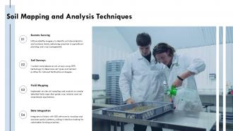
Soil Mapping And Analysis Techniques GIS In Agriculture PPT Slides ST AI SS
Increase audience engagement and knowledge by dispensing information using Soil Mapping And Analysis Techniques GIS In Agriculture PPT Slides ST AI SS. This template helps you present information on four stages. You can also present information on Soil Health Assessment, Geographic Information Systems, Precision Agriculture, Remote Sensing, Soil Data Visualization using this PPT design. This layout is completely editable so personaize it now to meet your audiences expectations.
-
Agricultural Mapping And Land Use Optimization Via GIS PPT Presentation AT
Do not compromise on a template that erodes your messages impact. Introducing our engaging Agricultural Mapping And Land Use Optimization Via GIS PPT Presentation AT complete deck, thoughtfully crafted to grab your audiences attention instantly. With this deck, effortlessly download and adjust elements, streamlining the customization process. Whether you are using Microsoft versions or Google Slides, it fits seamlessly into your workflow. Furthermore, it is accessible in JPG, JPEG, PNG, and PDF formats, facilitating easy sharing and editing. Not only that you also play with the color theme of your slides making it suitable as per your audiences preference.
-
Geoanalytics With GIS Maps Dashboards PPT Outline AT
Step up your game with our enchanting Geoanalytics With GIS Maps Dashboards PPT Outline AT deck, guaranteed to leave a lasting impression on your audience. Crafted with a perfect balance of simplicity, and innovation, our deck empowers you to alter it to your specific needs. You can also change the color theme of the slide to mold it to your companys specific needs. Save time with our ready-made design, compatible with Microsoft versions and Google Slides. Additionally, its available for download in various formats including JPG, JPEG, and PNG. Outshine your competitors with our fully editable and customized deck.
-
Geospatial Intelligence Mapping PPT Template VA
Every decision hinges on where things actually stand and that clarity is exactly what your next briefing will deliver. This presentation deck transforms dense location data into sharp instantly readable narratives that your stakeholders will grasp within seconds. With modern slide design and data visualization tailored for defense logistics and urban planning sectors you can plot coordinates overlay critical layers and communicate complex movements without losing your audiences attention. The editable slides let you adjust every element to match your mission brief or corporate presentation style. Stop wrestling with clunky visuals and start guiding teams toward decisive action with a polished professional PPT built for precision.
-
Addressing The GPS Market Dynamics On Map PPT Designs AT
Do not compromise on a template that erodes your messages impact. Introducing our engaging Addressing The GPS Market Dynamics On Map PPT Designs AT complete deck, thoughtfully crafted to grab your audiences attention instantly. With this deck, effortlessly download and adjust elements, streamlining the customization process. Whether you are using Microsoft versions or Google Slides, it fits seamlessly into your workflow. Furthermore, it is accessible in JPG, JPEG, PNG, and PDF formats, facilitating easy sharing and editing. Not only that you also play with the color theme of your slides making it suitable as per your audiences preference.
-
Mastering Maps Compass And GPS Systems PPT Sample AT
Ditch the Dull templates and opt for our engaging Mastering Maps Compass And GPS Systems PPT Sample AT deck to attract your audience. Our visually striking design effortlessly combines creativity with functionality, ensuring your content shines through. Compatible with Microsoft versions and Google Slides, it offers seamless integration of presentation. Save time and effort with our pre designed PPT layout, while still having the freedom to customize fonts, colors, and everything you ask for. With the ability to download in various formats like JPG, JPEG, and PNG, sharing your slides has never been easier. From boardroom meetings to client pitches, this deck can be the secret weapon to leaving a lasting impression.
-
GIS for Environmental Management PPT Summary VA
Good stewardship starts with a clear view of the ground beneath your feet. You need to translate complex spatial data into decisions that protect natural resources and this deck helps you do exactly that. Built around the core principles of GIS for environmental management the summary breaks down habitat analysis land use planning and resource tracking into digestible insights. The modern slide design turns raw coordinates into compelling visual stories making it easier to align stakeholders around conservation goals. Whether you are presenting to municipal boards or internal teams these editable slides work as a practical corporate presentation sparing you hours of formatting while keeping your message precise and persuasive.
-
Integrating Remote Sensing And GIS Geospatial Intelligence PPT Presentation AT
Do not compromise on a template that erodes your messages impact. Introducing our engaging Integrating Remote Sensing And GIS Geospatial Intelligence PPT Presentation AT complete deck, thoughtfully crafted to grab your audiences attention instantly. With this deck, effortlessly download and adjust elements, streamlining the customization process. Whether you are using Microsoft versions or Google Slides, it fits seamlessly into your workflow. Furthermore, it is accessible in JPG, JPEG, PNG, and PDF formats, facilitating easy sharing and editing. Not only that you also play with the color theme of your slides making it suitable as per your audiences preference.
-
RF Planning Using Geospatial Data And Mapping PPT Example AT
While your presentation may contain top-notch content, if it lacks visual appeal, you are not fully engaging your audience. Introducing our RF Planning Using Geospatial Data And Mapping PPT Example AT deck, designed to engage your audience. Our complete deck boasts a seamless blend of Creativity and versatility. You can effortlessly customize elements and color schemes to align with your brand identity. Save precious time with our pre-designed template, compatible with Microsoft versions and Google Slides. Plus, its downloadable in multiple formats like JPG, JPEG, and PNG. Elevate your presentations and outshine your competitors effortlessly with our visually stunning 100 percent editable deck.
-
Indiana GIS Maps And Data Visualization PPT Structure AT
Step up your game with our enchanting Indiana GIS Maps And Data Visualization PPT Structure AT deck, guaranteed to leave a lasting impression on your audience. Crafted with a perfect balance of simplicity, and innovation, our deck empowers you to alter it to your specific needs. You can also change the color theme of the slide to mold it to your companys specific needs. Save time with our ready-made design, compatible with Microsoft versions and Google Slides. Additionally, its available for download in various formats including JPG, JPEG, and PNG. Outshine your competitors with our fully editable and customized deck.
-
GIS Project Management PPT Sample VA
Deadlines slipping field data scattered and stakeholders asking for updates you cannot quite visualize yet. That is the daily reality of geospatial work and it demands more than standard bullet points. This GIS Project Management PPT sample turns complex workflows into a clear visual story giving you editable slides that map milestones resource allocation and risk tracking directly onto your project timeline. Built for modern slide design these presentation graphics help you communicate technical progress to non technical executives without losing precision. Whether you are prepping a status report or a full strategy deck this presentation bundle offers the professional PPT structure to keep every phase on track.
-
Spatial Data Infrastructure Projects Powered By GIS PPT Guidelines AT
Step up your game with our enchanting Spatial Data Infrastructure Projects Powered By GIS PPT Guidelines AT deck, guaranteed to leave a lasting impression on your audience. Crafted with a perfect balance of simplicity, and innovation, our deck empowers you to alter it to your specific needs. You can also change the color theme of the slide to mold it to your companys specific needs. Save time with our ready made design, compatible with Microsoft versions and Google Slides. Additionally, its available for download in various formats including JPG, JPEG, and PNG. Outshine your competitors with our fully editable and customized deck.
-
Geoint Geospatial Intelligence Mapping Analysis Ppt Template ST AI
Ditch the Dull templates and opt for our engaging Geoint Geospatial Intelligence Mapping Analysis Ppt Template ST AI deck to attract your audience. Our visually striking design effortlessly combines creativity with functionality, ensuring your content shines through. Compatible with Microsoft versions and Google Slides, it offers seamless integration of presentation. Save time and effort with our pre designed PPT layout, while still having the freedom to customize fonts, colors, and everything you ask for. With the ability to download in various formats like JPG, JPEG, and PNG, sharing your slides has never been easier. From boardroom meetings to client pitches, this deck can be the secret weapon to leaving a lasting impression.
-
Mapping Geographic Data For Strategic Insights PPT Summary AT
Step up your game with our enchanting Mapping Geographic Data For Strategic Insights PPT Summary AT deck, guaranteed to leave a lasting impression on your audience. Crafted with a perfect balance of simplicity, and innovation, our deck empowers you to alter it to your specific needs. You can also change the color theme of the slide to mold it to your companys specific needs. Save time with our ready made design, compatible with Microsoft versions and Google Slides. Additionally, its available for download in various formats including JPG, JPEG, and PNG. Outshine your competitors with our fully editable and customized deck.
-
Managing Primary And Secondary GIS Data Capture Methods PPT Guidelines AT
Do not compromise on a template that erodes your messages impact. Introducing our engaging Managing Primary And Secondary GIS Data Capture Methods PPT Guidelines AT complete deck, thoughtfully crafted to grab your audiences attention instantly. With this deck, effortlessly download and adjust elements, streamlining the customization process. Whether you are using Microsoft versions or Google Slides, it fits seamlessly into your workflow. Furthermore, it is accessible in JPG, JPEG, PNG, and PDF formats, facilitating easy sharing and editing. Not only that you also play with the color theme of your slides making it suitable as per your audiences preference.
-
Using Lidar And GPS Sensors For Accurate Drone Mapping PPT Example AT
While your presentation may contain top-notch content, if it lacks visual appeal, you are not fully engaging your audience. Introducing our Using Lidar And GPS Sensors For Accurate Drone Mapping PPT Example AT deck, designed to engage your audience. Our complete deck boasts a seamless blend of Creativity and versatility. You can effortlessly customize elements and color schemes to align with your brand identity. Save precious time with our pre-designed template, compatible with Microsoft versions and Google Slides. Plus, its downloadable in multiple formats like JPG, JPEG, and PNG. Elevate your presentations and outshine your competitors effortlessly with our visually stunning 100 percent editable deck.
-
Geographic Information System Architecture PPT Mockup VA
Every layer of your spatial data infrastructure deserves a clear voice and that clarity starts here. This Geographic Information System Architecture PPT mockup turns complex data flows and system interactions into a visual story your stakeholders will actually follow. Instead of wrestling with dense technical diagrams you get a presentation deck where each architectural tier is mapped to intuitive editable slides. Perfect for explaining system integrations to non technical teams or presenting a scalable strategy to decision makers these business slides help you bridge the gap between raw geospatial data and actionable insight. Make your next technical briefing a compelling narrative with this modern slide design ready for PowerPoint and Google Slides.
-
World Map GPS Navigation Location Indicator PPT Information AT
Do not compromise on a template that erodes your messages impact. Introducing our engaging World Map GPS Navigation Location Indicator PPT Information AT complete deck, thoughtfully crafted to grab your audiences attention instantly. With this deck, effortlessly download and adjust elements, streamlining the customization process. Whether you are using Microsoft versions or Google Slides, it fits seamlessly into your workflow. Furthermore, it is accessible in JPG, JPEG, PNG, and PDF formats, facilitating easy sharing and editing. Not only that you also play with the color theme of your slides making it suitable as per your audiences preference.
-
GIS Tools For Pest Disease Risk Forecasting PPT Summary AT
Step up your game with our enchanting GIS Tools For Pest Disease Risk Forecasting PPT Summary AT deck, guaranteed to leave a lasting impression on your audience. Crafted with a perfect balance of simplicity, and innovation, our deck empowers you to alter it to your specific needs. You can also change the color theme of the slide to mold it to your companys specific needs. Save time with our ready-made design, compatible with Microsoft versions and Google Slides. Additionally, its available for download in various formats including JPG, JPEG, and PNG. Outshine your competitors with our fully editable and customized deck.
-
Location Of Ghent City In Belgium Map
This slide shows geographical location of Ghent city in map of Belgium country with provinces border such as West Fianders, Antwerp and Hainut. Presenting our set of slides with Location Of Ghent City In Belgium Map. This exhibits information on three stages of the process. This is an easy to edit and innovatively designed PowerPoint template. So download immediately and highlight information on Ghent.
-
Mastering GIS Governance Pyramid PPT Outline AT
Ditch the Dull templates and opt for our engaging Mastering GIS Governance Pyramid PPT Outline AT deck to attract your audience. Our visually striking design effortlessly combines creativity with functionality, ensuring your content shines through. Compatible with Microsoft versions and Google Slides, it offers seamless integration of presentation. Save time and effort with our pre designed PPT layout, while still having the freedom to customize fonts, colors, and everything you ask for. With the ability to download in various formats like JPG, JPEG, and PNG, sharing your slides has never been easier. From boardroom meetings to client pitches, this deck can be the secret weapon to leaving a lasting impression.
-
Developing An Effective Systems Map Framework PPT Slides AT
Ditch the Dull templates and opt for our engaging Developing An Effective Systems Map Framework PPT Slides AT deck to attract your audience. Our visually striking design effortlessly combines creativity with functionality, ensuring your content shines through. Compatible with Microsoft versions and Google Slides, it offers seamless integration of presentation. Save time and effort with our pre designed PPT layout, while still having the freedom to customize fonts, colors, and everything you ask for. With the ability to download in various formats like JPG, JPEG, and PNG, sharing your slides has never been easier. From boardroom meetings to client pitches, this deck can be the secret weapon to leaving a lasting impression.
-
Integration Data Mapping PPT Demonstration VA
Getting lost in a web of disconnected systems drains momentum and muddles the story your numbers should tell. You need a clear bridge between raw sources and meaningful insight and this Integration and Data Mapping ppt demonstration transforms that complex journey into a visual narrative anyone can follow. Built for modern slide design these business slides turn intricate technical flows into intuitive diagrams making your architecture instantly understandable. Each editable slide serves as a strategy deck for aligning teams on source connections and transformation logic while data visualization elements clarify the value of each link. This professional PPT helps you showcase governance and clarity ensuring stakeholders see the intelligence behind every integrated data point.
-
Data Mapping Integration Presentation PPT Template AT
Do not compromise on a template that erodes your messages impact. Introducing our engaging Data Mapping Integration Presentation PPT Template AT complete deck, thoughtfully crafted to grab your audiences attention instantly. With this deck, effortlessly download and adjust elements, streamlining the customization process. Whether you are using Microsoft versions or Google Slides, it fits seamlessly into your workflow. Furthermore, it is accessible in JPG, JPEG, PNG, and PDF formats, facilitating easy sharing and editing. Not only that you also play with the color theme of your slides making it suitable as per your audiences preference.
-
Map For Geographic And Location Based Data PPT Mockup AT
While your presentation may contain top-notch content, if it lacks visual appeal, you are not fully engaging your audience. Introducing our Map For Geographic And Location Based Data PPT Mockup AT deck, designed to engage your audience. Our complete deck boasts a seamless blend of Creativity and versatility. You can effortlessly customize elements and color schemes to align with your brand identity. Save precious time with our pre-designed template, compatible with Microsoft versions and Google Slides. Plus, its downloadable in multiple formats like JPG, JPEG, and PNG. Elevate your presentations and outshine your competitors effortlessly with our visually stunning 100 percent editable deck.
-
Geospatial Data Infrastructure PPT Slides VA
Getting inconsistent data from different mapping sources can silently derail an entire project. This deck turns scattered location based information into a single coherent operational picture that stakeholders can actually follow. Instead of wrestling with cluttered diagrams you get a structured narrative that walks your team from raw coordinates to strategic insight making complex infrastructure decisions feel straightforward. The visual storytelling anchors every point in clear context rich graphics so technical audiences stay engaged while executives quickly grasp the core value. Ideal for municipal planning reviews or investor discussions these editable slides adapt to your exact workflow. Present the architecture of your Geospatial Data Infrastructure with confidence and clarity that leaves no room for misinterpretation. Your next briefing will finally feel precise.