

Powerpoint Templates for Spatial Data
Save time and engage your audience with our fully editable PowerPoint PPT Templates and Slides.
-

Spatial Data Infrastructure Projects Powered By GIS PPT Guidelines AT
Step up your game with our enchanting Spatial Data Infrastructure Projects Powered By GIS PPT Guidelines AT deck, guaranteed to leave a lasting impression on your audience. Crafted with a perfect balance of simplicity, and innovation, our deck empowers you to alter it to your specific needs. You can also change the color theme of the slide to mold it to your companys specific needs. Save time with our ready made design, compatible with Microsoft versions and Google Slides. Additionally, its available for download in various formats including JPG, JPEG, and PNG. Outshine your competitors with our fully editable and customized deck.
-

Geostatistics Advanced Techniques For Spatial Data Analysis And Interpretation Ppt Template ST AI
While your presentation may contain top notch content, if it lacks visual appeal, youre not fully engaging your audience. Introducing our Geostatistics Advanced Techniques For Spatial Data Analysis And Interpretation Ppt Template ST AI deck, designed to engage your audience. Our complete deck boasts a seamless blend of Creativity and versatility. You can effortlessly customize elements and color schemes to align with your brand identity. Save precious time with our pre designed template, compatible with Microsoft versions and Google Slides. Plus, its downloadable in multiple formats like JPG, JPEG, and PNG. Elevate your presentations and outshine your competitors effortlessly with our visually stunning 100 percent editable deck.
-
Spatial Data Infrastructure SDI Geographic Information Systems PPT Slides ST AI
Dont compromise on a template that erodes your messages impact. Introducing our engaging Spatial Data Infrastructure SDI Geographic Information Systems PPT Slides ST AI complete deck, thoughtfully crafted to grab your audiences attention instantly. With this deck, effortlessly download and adjust elements, streamlining the customization process. Whether youre using Microsoft versions or Google Slides, it fits seamlessly into your workflow. Furthermore, its accessible in JPG, JPEG, PNG, and PDF formats, facilitating easy sharing and editing. Not only that you also play with the color theme of your slides making it suitable as per your audiences preference.
-
Standards And Policies For Spatial Data Infrastructure Development PPT Summary AT
While your presentation may contain top-notch content, if it lacks visual appeal, you are not fully engaging your audience. Introducing our Standards And Policies For Spatial Data Infrastructure Development PPT Summary AT deck, designed to engage your audience. Our complete deck boasts a seamless blend of Creativity and versatility. You can effortlessly customize elements and color schemes to align with your brand identity. Save precious time with our pre-designed template, compatible with Microsoft versions and Google Slides. Plus, its downloadable in multiple formats like JPG, JPEG, and PNG. Elevate your presentations and outshine your competitors effortlessly with our visually stunning 100 percent editable deck.
-
Vector Database Spatial Data Geospatial Analysis PPT Presentation ST AI
While your presentation may contain top-notch content, if it lacks visual appeal, youre not fully engaging your audience. Introducing our Vector Database Spatial Data Geospatial Analysis PPT Presentation ST AI deck, designed to engage your audience. Our complete deck boasts a seamless blend of Creativity and versatility. You can effortlessly customize elements and color schemes to align with your brand identity. Save precious time with our pre-designed template, compatible with Microsoft versions and Google Slides. Plus, its downloadable in multiple formats like JPG, JPEG, and PNG. Elevate your presentations and outshine your competitors effortlessly with our visually stunning 100 percent editable deck.
-
Georeferencing Techniques Unlocking Spatial Data Insights PPT Example ST AI
Step up your game with our enchanting Georeferencing Techniques Unlocking Spatial Data Insights PPT Example ST AI deck, guaranteed to leave a lasting impression on your audience. Crafted with a perfect balance of simplicity, and innovation, our deck empowers you to alter it to your specific needs. You can also change the color theme of the slide to mold it to your companys specific needs. Save time with our ready-made design, compatible with Microsoft versions and Google Slides. Additionally, its available for download in various formats including JPG, JPEG, and PNG. Outshine your competitors with our fully editable and customized deck.
-
Implementing Spatial Data Infrastructure For Better PPT Information AT
Do not compromise on a template that erodes your messages impact. Introducing our engaging Implementing Spatial Data Infrastructure For Better PPT Information AT complete deck, thoughtfully crafted to grab your audiences attention instantly. With this deck, effortlessly download and adjust elements, streamlining the customization process. Whether you are using Microsoft versions or Google Slides, it fits seamlessly into your workflow. Furthermore, it is accessible in JPG, JPEG, PNG, and PDF formats, facilitating easy sharing and editing. Not only that you also play with the color theme of your slides making it suitable as per your audiences preference.
-
Role Of Metadata In Spatial Data Infrastructure PPT Example AT
While your presentation may contain top-notch content, if it lacks visual appeal, you are not fully engaging your audience. Introducing our Role Of Metadata In Spatial Data Infrastructure PPT Example AT deck, designed to engage your audience. Our complete deck boasts a seamless blend of Creativity and versatility. You can effortlessly customize elements and color schemes to align with your brand identity. Save precious time with our pre-designed template, compatible with Microsoft versions and Google Slides. Plus, its downloadable in multiple formats like JPG, JPEG, and PNG. Elevate your presentations and outshine your competitors effortlessly with our visually stunning 100 percent editable deck.
-
How To Use Non Spatial Data Effectively PPT PowerPoint AT
Ditch the Dull templates and opt for our engaging How To Use Non Spatial Data Effectively PPT PowerPoint AT deck to attract your audience. Our visually striking design effortlessly combines creativity with functionality, ensuring your content shines through. Compatible with Microsoft versions and Google Slides, it offers seamless integration of presentation. Save time and effort with our pre-designed PPT layout, while still having the freedom to customize fonts, colors, and everything you ask for. With the ability to download in various formats like JPG, JPEG, and PNG, sharing your slides has never been easier. From boardroom meetings to client pitches, this deck can be the secret weapon to leaving a lasting impression.
-
Key Features Of Non Spatial Data PPT Sample AT
Do not compromise on a template that erodes your messages impact. Introducing our engaging Key Features Of Non Spatial Data PPT Sample AT complete deck, thoughtfully crafted to grab your audiences attention instantly. With this deck, effortlessly download and adjust elements, streamlining the customization process. Whether you are using Microsoft versions or Google Slides, it fits seamlessly into your workflow. Furthermore, it is accessible in JPG, JPEG, PNG, and PDF formats, facilitating easy sharing and editing. Not only that you also play with the color theme of your slides making it suitable as per your audiences preference.
-
Utilizing GIS For Spatial Data Analysis PPT Slides AT
Step up your game with our enchanting Utilizing GIS For Spatial Data Analysis PPT Slides AT deck, guaranteed to leave a lasting impression on your audience. Crafted with a perfect balance of simplicity, and innovation, our deck empowers you to alter it to your specific needs. You can also change the color theme of the slide to mold it to your companys specific needs. Save time with our ready made design, compatible with Microsoft versions and Google Slides. Additionally, its available for download in various formats including JPG, JPEG, and PNG. Outshine your competitors with our fully editable and customized deck.
-
National Spatial Data Infrastructure Models PPT Mockup AT
Do not compromise on a template that erodes your messages impact. Introducing our engaging National Spatial Data Infrastructure Models PPT Mockup AT complete deck, thoughtfully crafted to grab your audiences attention instantly. With this deck, effortlessly download and adjust elements, streamlining the customization process. Whether you are using Microsoft versions or Google Slides, it fits seamlessly into your workflow. Furthermore, it is accessible in JPG, JPEG, PNG, and PDF formats, facilitating easy sharing and editing. Not only that you also play with the color theme of your slides making it suitable as per your audiences preference.
-
Non Spatial Data Vs Spatial Data Comparison PPT Summary AT
Do not compromise on a template that erodes your messages impact. Introducing our engaging Non Spatial Data Vs Spatial Data Comparison PPT Summary AT complete deck, thoughtfully crafted to grab your audiences attention instantly. With this deck, effortlessly download and adjust elements, streamlining the customization process. Whether you are using Microsoft versions or Google Slides, it fits seamlessly into your workflow. Furthermore, it is accessible in JPG, JPEG, PNG, and PDF formats, facilitating easy sharing and editing. Not only that you also play with the color theme of your slides making it suitable as per your audiences preference.
-
Spatial Data Infrastructure Components Overview PPT Slides AT
Step up your game with our enchanting Spatial Data Infrastructure Components Overview PPT Slides AT deck, guaranteed to leave a lasting impression on your audience. Crafted with a perfect balance of simplicity, and innovation, our deck empowers you to alter it to your specific needs. You can also change the color theme of the slide to mold it to your companys specific needs. Save time with our ready made design, compatible with Microsoft versions and Google Slides. Additionally, its available for download in various formats including JPG, JPEG, and PNG. Outshine your competitors with our fully editable and customized deck.
-
Spatial Data Infrastructure Software Components And Their Functions PPT Slides AT
Do not compromise on a template that erodes your messages impact. Introducing our engaging Spatial Data Infrastructure Software Components And Their Functions PPT Slides AT complete deck, thoughtfully crafted to grab your audiences attention instantly. With this deck, effortlessly download and adjust elements, streamlining the customization process. Whether you are using Microsoft versions or Google Slides, it fits seamlessly into your workflow. Furthermore, it is accessible in JPG, JPEG, PNG, and PDF formats, facilitating easy sharing and editing. Not only that you also play with the color theme of your slides making it suitable as per your audiences preference.
-
Spatial Data Visualization Techniques PPT Slides AT
Ditch the Dull templates and opt for our engaging Spatial Data Visualization Techniques PPT Slides AT deck to attract your audience. Our visually striking design effortlessly combines creativity with functionality, ensuring your content shines through. Compatible with Microsoft versions and Google Slides, it offers seamless integration of presentation. Save time and effort with our pre designed PPT layout, while still having the freedom to customize fonts, colors, and everything you ask for. With the ability to download in various formats like JPG, JPEG, and PNG, sharing your slides has never been easier. From boardroom meetings to client pitches, this deck can be the secret weapon to leaving a lasting impression.
-
Non Spatial Data Geographic Information Systems Explained PPT Structure AT
Step up your game with our enchanting Non Spatial Data Geographic Information Systems Explained PPT Structure AT deck, guaranteed to leave a lasting impression on your audience. Crafted with a perfect balance of simplicity, and innovation, our deck empowers you to alter it to your specific needs. You can also change the color theme of the slide to mold it to your companys specific needs. Save time with our ready made design, compatible with Microsoft versions and Google Slides. Additionally, its available for download in various formats including JPG, JPEG, and PNG. Outshine your competitors with our fully editable and customized deck.
-
Hierarchical Geoclustering For Spatial Data Analysis PPT Template AT
Step up your game with our enchanting Hierarchical Geoclustering For Spatial Data Analysis PPT Template AT deck, guaranteed to leave a lasting impression on your audience. Crafted with a perfect balance of simplicity, and innovation, our deck empowers you to alter it to your specific needs. You can also change the color theme of the slide to mold it to your companys specific needs. Save time with our ready-made design, compatible with Microsoft versions and Google Slides. Additionally, its available for download in various formats including JPG, JPEG, and PNG. Outshine your competitors with our fully editable and customized deck.
-
Spatial Data Infrastructure Framework For Efficient Geospatial Data Sharing PPT Designs AT
Do not compromise on a template that erodes your messages impact. Introducing our engaging Spatial Data Infrastructure Framework For Efficient Geospatial Data Sharing PPT Designs AT complete deck, thoughtfully crafted to grab your audiences attention instantly. With this deck, effortlessly download and adjust elements, streamlining the customization process. Whether you are using Microsoft versions or Google Slides, it fits seamlessly into your workflow. Furthermore, it is accessible in JPG, JPEG, PNG, and PDF formats, facilitating easy sharing and editing. Not only that you also play with the color theme of your slides making it suitable as per your audiences preference.
-
Non Spatial Data Database Management PPT Designs AT
Ditch the Dull templates and opt for our engaging Non Spatial Data Database Management PPT Designs AT deck to attract your audience. Our visually striking design effortlessly combines creativity with functionality, ensuring your content shines through. Compatible with Microsoft versions and Google Slides, it offers seamless integration of presentation. Save time and effort with our pre designed PPT layout, while still having the freedom to customize fonts, colors, and everything you ask for. With the ability to download in various formats like JPG, JPEG, and PNG, sharing your slides has never been easier. From boardroom meetings to client pitches, this deck can be the secret weapon to leaving a lasting impression.
-
Geoanalytics And Spatial Data Analysis Technologies PPT Example AT
Step up your game with our enchanting Geoanalytics And Spatial Data Analysis Technologies PPT Example AT deck, guaranteed to leave a lasting impression on your audience. Crafted with a perfect balance of simplicity, and innovation, our deck empowers you to alter it to your specific needs. You can also change the color theme of the slide to mold it to your companys specific needs. Save time with our ready made design, compatible with Microsoft versions and Google Slides. Additionally, its available for download in various formats including JPG, JPEG, and PNG. Outshine your competitors with our fully editable and customized deck.
-
Real Time Spatial Data Visualization PPT Outline AT
Ditch the Dull templates and opt for our engaging Real Time Spatial Data Visualization PPT Outline AT deck to attract your audience. Our visually striking design effortlessly combines creativity with functionality, ensuring your content shines through. Compatible with Microsoft versions and Google Slides, it offers seamless integration of presentation. Save time and effort with our pre designed PPT layout, while still having the freedom to customize fonts, colors, and everything you ask for. With the ability to download in various formats like JPG, JPEG, and PNG, sharing your slides has never been easier. From boardroom meetings to client pitches, this deck can be the secret weapon to leaving a lasting impression.
-
Exploring Spatial Sampling Techniques For Accurate Data Analysis PPT Sample ST AI
Dont compromise on a template that erodes your messages impact. Introducing our engaging Exploring Spatial Sampling Techniques For Accurate Data Analysis PPT Sample ST AI complete deck, thoughtfully crafted to grab your audiences attention instantly. With this deck, effortlessly download and adjust elements, streamlining the customization process. Whether youre using Microsoft versions or Google Slides, it fits seamlessly into your workflow. Furthermore, its accessible in JPG, JPEG, PNG, and PDF formats, facilitating easy sharing and editing. Not only that you also play with the color theme of your slides making it suitable as per your audiences preference.
-
Non Spatial Data Analysis In GIS PPT Information AT
Do not compromise on a template that erodes your messages impact. Introducing our engaging Non Spatial Data Analysis In GIS PPT Information AT complete deck, thoughtfully crafted to grab your audiences attention instantly. With this deck, effortlessly download and adjust elements, streamlining the customization process. Whether you are using Microsoft versions or Google Slides, it fits seamlessly into your workflow. Furthermore, it is accessible in JPG, JPEG, PNG, and PDF formats, facilitating easy sharing and editing. Not only that you also play with the color theme of your slides making it suitable as per your audiences preference.
-
How Spatial Data Infrastructure Enhances PPT Example AT
Step up your game with our enchanting How Spatial Data Infrastructure Enhances PPT Example AT deck, guaranteed to leave a lasting impression on your audience. Crafted with a perfect balance of simplicity, and innovation, our deck empowers you to alter it to your specific needs. You can also change the color theme of the slide to mold it to your companys specific needs. Save time with our ready made design, compatible with Microsoft versions and Google Slides. Additionally, its available for download in various formats including JPG, JPEG, and PNG. Outshine your competitors with our fully editable and customized deck.
-
Spatio Temporal Modeling Analyzing Spatial Temporal Data PPT Slides ST AI
While your presentation may contain top-notch content, if it lacks visual appeal, youre not fully engaging your audience. Introducing our Spatio Temporal Modeling Analyzing Spatial Temporal Data PPT Slides ST AI deck, designed to engage your audience. Our complete deck boasts a seamless blend of Creativity and versatility. You can effortlessly customize elements and color schemes to align with your brand identity. Save precious time with our pre-designed template, compatible with Microsoft versions and Google Slides. Plus, its downloadable in multiple formats like JPG, JPEG, and PNG. Elevate your presentations and outshine your competitors effortlessly with our visually stunning 100 percent editable deck.
-
Spatial Data Infrastructure Integrating Technology People And Policies PPT Information AT
While your presentation may contain top-notch content, if it lacks visual appeal, you are not fully engaging your audience. Introducing our Spatial Data Infrastructure Integrating Technology People And Policies PPT Information AT deck, designed to engage your audience. Our complete deck boasts a seamless blend of Creativity and versatility. You can effortlessly customize elements and color schemes to align with your brand identity. Save precious time with our pre-designed template, compatible with Microsoft versions and Google Slides. Plus, its downloadable in multiple formats like JPG, JPEG, and PNG. Elevate your presentations and outshine your competitors effortlessly with our visually stunning 100 percent editable deck.
-
Spatial Data Infrastructure Best Practices PPT Mockup AT
Step up your game with our enchanting Spatial Data Infrastructure Best Practices PPT Mockup AT deck, guaranteed to leave a lasting impression on your audience. Crafted with a perfect balance of simplicity, and innovation, our deck empowers you to alter it to your specific needs. You can also change the color theme of the slide to mold it to your companys specific needs. Save time with our ready made design, compatible with Microsoft versions and Google Slides. Additionally, its available for download in various formats including JPG, JPEG, and PNG. Outshine your competitors with our fully editable and customized deck.
-
Spatial Data Infrastructure Powerpoint Template Bundles Ppt Sample
Deliver a credible and compelling presentation by deploying this Spatial Data Infrastructure Powerpoint Template Bundles Ppt Sample. Intensify your message with the right graphics, images, icons, etc. presented in this complete deck. This PPT template is a great starting point to convey your messages and build a good collaboration. The twenty slides added to this PowerPoint slideshow helps you present a thorough explanation of the topic. You can use it to study and present various kinds of information in the form of stats, figures, data charts, and many more. This Spatial Data Infrastructure Powerpoint Template Bundles Ppt Sample PPT slideshow is available for use in standard and widescreen aspects ratios. So, you can use it as per your convenience. Apart from this, it can be downloaded in PNG, JPG, and PDF formats, all completely editable and modifiable. The most profound feature of this PPT design is that it is fully compatible with Google Slides making it suitable for every industry and business domain.
-
Spatial Data Integration Methods Geoanalytics PPT Slides ST AI SS
Introducing Spatial Data Integration Methods Geoanalytics PPT Slides ST AI SS to increase your presentation threshold. Encompassed with two stages, this template is a great option to educate and entice your audience. Dispence information on Geographic Information Systems, Data Fusion Techniques, Spatial Data Analysis, Remote Sensing Integration, Big Data Analytics, Spatial Data Mining, using this template. Grab it now to reap its full benefits.
-
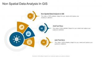
Non Spatial Data Analysis In GIS Ppt Slides Cpp
Presenting Non Spatial Data Analysis In GIS Ppt Slides Cpp slide which is completely adaptable. The graphics in this PowerPoint slide showcase three stages that will help you succinctly convey the information. In addition, you can alternate the color, font size, font type, and shapes of this PPT layout according to your content. This PPT presentation can be accessed with Google Slides and is available in both standard screen and widescreen aspect ratios. It is also a useful set to elucidate topics like Non Spatial Data Analysis In GIS. This well-structured design can be downloaded in different formats like PDF, JPG, and PNG. So, without any delay, click on the download button now.
-
Regression Analysis Of Spatial Data In Ppt Powerpoint Presentation Slide Templates Cpp
Presenting Regression Analysis Of Spatial Data In Ppt Powerpoint Presentation Slide Templates Cpp slide which is completely adaptable. The graphics in this PowerPoint slide showcase four stages that will help you succinctly convey the information. In addition, you can alternate the color, font size, font type, and shapes of this PPT layout according to your content. This PPT presentation can be accessed with Google Slides and is available in both standard screen and widescreen aspect ratios. It is also a useful set to elucidate topics like Regression Analysis of Spatial Data. This well-structured design can be downloaded in different formats like PDF, JPG, and PNG. So, without any delay, click on the download button now.
-
Gis And Spatial Data Analysis In Ppt Powerpoint Presentation Slide Templates Cpp
Presenting Gis And Spatial Data Analysis In Ppt Powerpoint Presentation Slide Templates Cpp slide which is completely adaptable. The graphics in this PowerPoint slide showcase four stages that will help you succinctly convey the information. In addition, you can alternate the color, font size, font type, and shapes of this PPT layout according to your content. This PPT presentation can be accessed with Google Slides and is available in both standard screen and widescreen aspect ratios. It is also a useful set to elucidate topics like Gis And Spatial Data Analysis. This well-structured design can be downloaded in different formats like PDF, JPG, and PNG. So, without any delay, click on the download button now.
-
Geo Data Fusion Techniques For Enhanced Spatial Analysis And Insights PPT PowerPoint ST AI
Step up your game with our enchanting Geo Data Fusion Techniques For Enhanced Spatial Analysis And Insights PPT PowerPoint ST AI deck, guaranteed to leave a lasting impression on your audience. Crafted with a perfect balance of simplicity, and innovation, our deck empowers you to alter it to your specific needs. You can also change the color theme of the slide to mold it to your companys specific needs. Save time with our ready-made design, compatible with Microsoft versions and Google Slides. Additionally, its available for download in various formats including JPG, JPEG, and PNG. Outshine your competitors with our fully editable and customized deck.
-
Analysis Spatial Data Illegal Mining In Ppt Powerpoint Presentation Slide Templates Cpp
Presenting our Analysis Spatial Data Illegal Mining In Ppt Powerpoint Presentation Slide Templates Cpp PowerPoint template design. This PowerPoint slide showcases six stages. It is useful to share insightful information on Analysis Spatial Data Illegal Mining This PPT slide can be easily accessed in standard screen and widescreen aspect ratios. It is also available in various formats like PDF, PNG, and JPG. Not only this, the PowerPoint slideshow is completely editable and you can effortlessly modify the font size, font type, and shapes according to your wish. Our PPT layout is compatible with Google Slides as well, so download and edit it as per your knowledge.
-
Gis Spatial Data Analysis In Ppt Powerpoint Presentation Slide Templates Cpp
Presenting Gis Spatial Data Analysis In Ppt Powerpoint Presentation Slide Templates Cpp slide which is completely adaptable. The graphics in this PowerPoint slide showcase five stages that will help you succinctly convey the information. In addition, you can alternate the color, font size, font type, and shapes of this PPT layout according to your content. This PPT presentation can be accessed with Google Slides and is available in both standard screen and widescreen aspect ratios. It is also a useful set to elucidate topics like Gis Spatial Data Analysis. This well-structured design can be downloaded in different formats like PDF, JPG, and PNG. So, without any delay, click on the download button now.
-
Spatial Data Analysis To Get Geographic Data Geospatial Technology For Environment Conservation TC SS
This slide provides glimpse about summary of spatial data analysis and modelling that helps in generating deeper insights from geographic data. It includes benefits such as urban planning, environmental studies, etc. Increase audience engagement and knowledge by dispensing information using Spatial Data Analysis To Get Geographic Data Geospatial Technology For Environment Conservation TC SS. This template helps you present information on four stages. You can also present information on Urban Planning, Environmental Studies, Disaster Management using this PPT design. This layout is completely editable so personaize it now to meet your audiences expectations.
-
Applications Of Integrated BIM And Spatial Data Infrastructure Ppt Template
The purpose of this slide is to highlight practical applications of integrating Building Information Modeling BIM with spatial data infrastructure, particularly Geographic Information Systems GIS. It includes elements such as flood analysis, line of sight analysis, etc. Presenting our set of slides with name Applications Of Integrated BIM And Spatial Data Infrastructure Ppt Template. This exhibits information on four stages of the process. This is an easy to edit and innovatively designed PowerPoint template. So download immediately and highlight information on Optimizing Resource Allocation, Flood Analysis, Traffic Management.
-
Challenges And Solutions In Implementing Spatial Data Infrastructur Ppt Example
The purpose of this slide is to highlight obstacles faced in SDI implementation and actionable steps to overcome them. It includes elements such as digital data availability, digital data accessibility, etc. Presenting our set of slides with name Challenges And Solutions In Implementing Spatial Data Infrastructur Ppt Example. This exhibits information on three stages of the process. This is an easy to edit and innovatively designed PowerPoint template. So download immediately and highlight information on Digital Data Accessibility, Adoption Of Standards, Digital Data Availability.
-
National Spatial Data Infrastructure Case Study Analysis Ppt Example
The purpose of this slide is to highlight implementation of national spatial data infrastructure in Sri Lanka to create environment where government organizations can cooperate. It includes elements such as overview, goals, etc. Presenting our well structured National Spatial Data Infrastructure Case Study Analysis Ppt Example. The topics discussed in this slide are Goals, Challenges, Solutions, Result. This is an instantly available PowerPoint presentation that can be edited conveniently. Download it right away and captivate your audience.
-
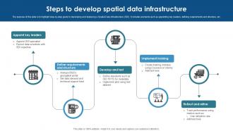
Steps To Develop Spatial Data Infrastructure Ppt Template
The purpose of this slide is to highlight step by step guide to developing and deploying a Spatial Data Infrastructure SDI. It includes elements such as appointing key leaders, defining requirements and structure, etc. Presenting our set of slides with name Steps To Develop Spatial Data Infrastructure Ppt Template. This exhibits information on five stages of the process. This is an easy to edit and innovatively designed PowerPoint template. So download immediately and highlight information on Appoint Key Leaders, Develop And Test, Implement Training.
-
Utilizing GIS For Spatial Data Analysis PPT Presentation ST AI SS
Introducing Utilizing GIS For Spatial Data Analysis PPT Presentation ST AI SS to increase your presentation threshold. Encompassed with one stages, this template is a great option to educate and entice your audience. Dispence information on Geographic Information Systems, Spatial Analysis Techniques, Data Visualization, Remote Sensing, using this template. Grab it now to reap its full benefits.
-
Spatial Data Structures And Representation PPT Sample ST AI SS
Introducing Spatial Data Structures And Representation PPT Sample ST AI SS to increase your presentation threshold. Encompassed with one stages, this template is a great option to educate and entice your audience. Dispence information on Geographic Information Systems, Spatial Data Modeling, Data Visualization Techniques, Geographic Data Formats, using this template. Grab it now to reap its full benefits.
-
Spatial Data Infrastructure Structural Design Ppt Example
The purpose of this slide is to highlight architecture of spatial data infrastructure for improving the comprehensiveness and accuracy of spatial analyses. It includes elements such as GIS tools, web geo portal, etc. Presenting our well structured Spatial Data Infrastructure Structural Design Ppt Example. The topics discussed in this slide are Metadata, Workflow Impact. This is an instantly available PowerPoint presentation that can be edited conveniently. Download it right away and captivate your audience.
-
Spatial Data Infrastructure Projects Powered By GIS Ppt Presentation
The purpose of this slide is to highlight GIS applications contributing to route optimization, environmental impact assessments. It includes elements such as Londons Crossrail project, high speed rail, etc. Introducing our Spatial Data Infrastructure Projects Powered By GIS Ppt Presentation set of slides. The topics discussed in these slides are Project, Location, Use Cases, Practical Impact. This is an immediately available PowerPoint presentation that can be conveniently customized. Download it and convince your audience.
-
Outcomes Of Spatial Data Infrastructure Project Ppt Template
The purpose of this slide is to highlight outcomes achieved from Spatial Data Infrastructure SDI project across different sectors in enhancing urban planning. It includes elements such as urban planning and development, smart cadastre of real property, etc. Presenting our set of slides with name Outcomes Of Spatial Data Infrastructure Project Ppt Template. This exhibits information on three stages of the process. This is an easy to edit and innovatively designed PowerPoint template. So download immediately and highlight information on Smart Cadastre Real Property, Precision Agriculture, Smart Farming.
-
Modernized Architecture Of Spatial Data Infrastructure Ppt Presentation
The purpose of this slide is to highlight strategic approach for evolving traditional Spatial Data Infrastructures SDIs into modern, flexible data spaces. It includes elements such as application programming interfaces, data validation, etc. Introducing our Modernized Architecture Of Spatial Data Infrastructure Ppt Presentation set of slides. The topics discussed in these slides are Data Preservation, Digital Government, Key Takeaways. This is an immediately available PowerPoint presentation that can be conveniently customized. Download it and convince your audience.
-
Key Drivers Of Spatial Data Infrastructure Ppt Presentation
The purpose of this slide is to highlight key drivers that spatial data infrastructure agencies need to follow in multiple state and national level. It includes elements such as process and policies, data, people, etc. Presenting our set of slides with name Key Drivers Of Spatial Data Infrastructure Ppt Presentation. This exhibits information on four stages of the process. This is an easy to edit and innovatively designed PowerPoint template. So download immediately and highlight information on Technology, Data, People, Process And Policies.
-
Key Components Of Spatial Data Infrastructure Ppt Example
The purpose of this slide is to highlight essential elements required to build and maintain an effective spatial data infrastructure SDI. It includes elements such as data, metadata, standards and policies. Introducing our premium set of slides with name Key Components Of Spatial Data Infrastructure Ppt Example. Ellicudate the four stages and present information using this PPT slide. This is a completely adaptable PowerPoint template design that can be used to interpret topics like Data, Metadata, Standards, Policies. So download instantly and tailor it with your information.
-
Key Applications Of Spatial Data Infrastructure Ppt Template
The purpose of this slide is to highlight applications of spatial data infrastructure for facilitating smarter decision making and sustainable development. It includes elements such as urban planning and development, environmental conservation, etc. Presenting our set of slides with name Key Applications Of Spatial Data Infrastructure Ppt Template. This exhibits information on four stages of the process. This is an easy to edit and innovatively designed PowerPoint template. So download immediately and highlight information on Disaster Management, Tourism And Marketing, Environmental Conservation.
-
Emerging Trends In Spatial Data Infrastructure Ppt Presentation
The purpose of this slide is to highlight trends in spatial data infrastructure SDI to inform stakeholders about latest developments. It includes elements such as cloud based solutions, IoT integration, etc. Introducing our premium set of slides with name Emerging Trends In Spatial Data Infrastructure Ppt Presentation. Ellicudate the three stages and present information using this PPT slide. This is a completely adaptable PowerPoint template design that can be used to interpret topics like Cloud Based Solutions, IOT Integration, AI And Machine Learning. So download instantly and tailor it with your information.
-
Spatial Data Capture Techniques Ppt Powerpoint ST AI SS
Present the topic in a bit more detail with this Spatial Data Capture Techniques Ppt Powerpoint ST AI SS. Use it as a tool for discussion and navigation on Geographic Information Systems, Remote Sensing, Data Collection Methods, Spatial Analysis. This template is free to edit as deemed fit for your organization. Therefore download it now.
-
Geospatial Data Management Strategies Spatial Data Infrastructure Ppt Presentation ST AI SS
Present the topic in a bit more detail with this Geospatial Data Management Strategies Spatial Data Infrastructure Ppt Presentation ST AI SS. Use it as a tool for discussion and navigation on Geographic Information Systems, Spatial Data Governance, Data Integration Techniques, Remote Sensing Applications. This template is free to edit as deemed fit for your organization. Therefore download it now.
-
Geoanalytics Geographic Data Spatial Analysis Technology PPT Presentation ST AI
Step up your game with our enchanting Geoanalytics Geographic Data Spatial Analysis Technology PPT Presentation ST AI deck, guaranteed to leave a lasting impression on your audience. Crafted with a perfect balance of simplicity, and innovation, our deck empowers you to alter it to your specific needs. You can also change the color theme of the slide to mold it to your companys specific needs. Save time with our ready-made design, compatible with Microsoft versions and Google Slides. Additionally, its available for download in various formats including JPG, JPEG, and PNG. Outshine your competitors with our fully editable and customized deck.
-
Continuous decision improvement process spatial analytics data enrichment
Presenting this set of slides with name - Continuous Decision Improvement Process Spatial Analytics Data Enrichment. This is an editable six stages graphic that deals with topics like Continuous Decision Improvement Process, Spatial Analytics, Data Enrichment to help convey your message better graphically. This product is a premium product available for immediate download, and is 100 percent editable in Powerpoint. Download this now and use it in your presentations to impress your audience.
-
Semi Circle Segments Circular Data And Spatial Analysis PPT Outline AT
Do not compromise on a template that erodes your messages impact. Introducing our engaging Semi Circle Segments Circular Data And Spatial Analysis PPT Outline AT complete deck, thoughtfully crafted to grab your audiences attention instantly. With this deck, effortlessly download and adjust elements, streamlining the customization process. Whether you are using Microsoft versions or Google Slides, it fits seamlessly into your workflow. Furthermore, it is accessible in JPG, JPEG, PNG, and PDF formats, facilitating easy sharing and editing. Not only that you also play with the color theme of your slides making it suitable as per your audiences preference.
-
Categorical Data Gis Spatial Analysis In Ppt Powerpoint Presentation Slide Templates Cpp
Presenting Categorical Data Gis Spatial Analysis In Ppt Powerpoint Presentation Slide Templates Cpp slide which is completely adaptable. The graphics in this PowerPoint slide showcase three stages that will help you succinctly convey the information. In addition, you can alternate the color, font size, font type, and shapes of this PPT layout according to your content. This PPT presentation can be accessed with Google Slides and is available in both standard screen and widescreen aspect ratios. It is also a useful set to elucidate topics like Categorical Data Gis Spatial Analysis. This well-structured design can be downloaded in different formats like PDF, JPG, and PNG. So, without any delay, click on the download button now.
-
Data Science Spatial Temporal Analysis In Ppt Powerpoint Presentation Slide Templates Cpp
Presenting our Data Science Spatial Temporal Analysis In Ppt Powerpoint Presentation Slide Templates Cpp PowerPoint template design. This PowerPoint slide showcases four stages. It is useful to share insightful information on Data Science Spatial Temporal Analysis This PPT slide can be easily accessed in standard screen and widescreen aspect ratios. It is also available in various formats like PDF, PNG, and JPG. Not only this, the PowerPoint slideshow is completely editable and you can effortlessly modify the font size, font type, and shapes according to your wish. Our PPT layout is compatible with Google Slides as well, so download and edit it as per your knowledge.
-
Spatial Analysis For Panel Data In Ppt Powerpoint Presentation Slide Templates Cpp
Presenting our Spatial Analysis For Panel Data In Ppt Powerpoint Presentation Slide Templates Cpp PowerPoint template design. This PowerPoint slide showcases four stages. It is useful to share insightful information on Spatial Analysis for Panel Data This PPT slide can be easily accessed in standard screen and widescreen aspect ratios. It is also available in various formats like PDF, PNG, and JPG. Not only this, the PowerPoint slideshow is completely editable and you can effortlessly modify the font size, font type, and shapes according to your wish. Our PPT layout is compatible with Google Slides as well, so download and edit it as per your knowledge.
-
Types of data sources with spatial information
Presenting this set of slides with name Types Of Data Sources With Spatial Information. This is a four stage process. The stages in this process are Data Sources, Social Media, Marketing. This is a completely editable PowerPoint presentation and is available for immediate download. Download now and impress your audience.