


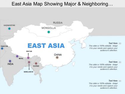
East asia map showing major and neighboring countries




Try Before you Buy Download Free Sample Product
 Impress Your
 Audience
 100%
100% Editable
 Save Hours
 of Time


Ensure goodwill continues to exist with our East Asia Map Showing Major And Neighboring Countries. Discredit discord creating acts.
People who downloaded this PowerPoint presentation also viewed the following :
East asia map showing major and neighboring countries with all 5 slides:
Tickle them pink with our East Asia Map Showing Major And Neighboring Countries. They will soon be laughing all the way to the bank.

FAQs for East asia map showing major
East Asia maps typically highlight major mountain ranges like the Himalayas and Japanese Alps, vast river systems including the Yangtze and Yellow Rivers, extensive coastlines along the Pacific Ocean, and significant desert regions such as the Gobi Desert. These geographical features enable businesses to understand regional logistics networks, agricultural zones, and strategic shipping routes, with many multinational corporations finding that geographical awareness enhances supply chain efficiency and market penetration strategies.
East Asia's complex political landscape significantly influences cartographic representations through territorial disputes, sovereignty claims, and diplomatic relationships that shape how borders, names, and regions are depicted. Maps from China, Japan, South Korea, and North Korea often show different boundary lines for contested areas like the South China Sea, Senkaku/Diaoyu Islands, and Korean Peninsula, ultimately reflecting each nation's political stance and territorial assertions.
East Asia typically includes China, Japan, South Korea, North Korea, Mongolia, and Taiwan on most regional maps. These countries share geographic proximity, significant cultural and historical connections, and increasingly integrated economic relationships, with many international organizations and businesses finding that this regional grouping facilitates strategic planning and market analysis across Asia's most economically dynamic zone.
East Asia maps typically highlight cultural landmarks including the Great Wall of China, Forbidden City, Mount Fuji, Angkor Wat, Gyeongbokgung Palace, and traditional temples across the region. These landmarks enhance geographical education by connecting students with historical significance, architectural heritage, and cultural diversity, with many educational institutions finding that visual cultural references improve spatial learning and cross-cultural understanding in increasingly globalized academic environments.
Historical events like Japanese colonization, the Korean War, Chinese civil war, and post-WWII territorial agreements fundamentally established East Asia's current borders and political divisions. These conflicts created today's distinct nations—North and South Korea's division, Taiwan's separate status, and disputed territories like the South China Sea—with many countries still navigating territorial tensions that directly stem from 20th-century geopolitical restructuring.
Physical maps of East Asia showcase natural features like mountain ranges, rivers, plateaus, and climate zones, while political maps display countries, capitals, borders, provinces, and administrative divisions. These complementary mapping approaches enable researchers, educators, and businesses to understand both geographical constraints and governmental structures across China, Japan, Korea, and Mongolia, ultimately delivering comprehensive regional analysis for strategic planning, educational curriculum development, and international business operations.
East Asia's high population density significantly influences map design through enlarged urban area representations, detailed transportation networks, and compressed spacing between major cities. Cartographers must balance showing densely packed metropolitan regions like Tokyo, Seoul, and Shanghai while maintaining readability, often using multi-scale approaches and selective feature emphasis to effectively communicate the region's concentrated settlement patterns.
Technology and digital mapping revolutionize East Asian understanding through satellite imagery, GIS analytics, real-time economic data visualization, demographic tracking, and interactive geographic platforms. These tools enable governments, businesses, and researchers to monitor urbanization patterns, trade routes, and regional development across China, Japan, Korea, and Southeast Asia, ultimately delivering strategic insights for investment decisions and policy planning.
East Asia's major rivers include the Yangtze, Yellow, Mekong, Amur, and Yalu rivers, while significant mountain ranges encompass the Himalayas, Altai, Kunlun, Tian Shan, and Japanese Alps. These geographical features streamline regional trade routes, enhance agricultural productivity, and deliver strategic resource distribution, with many countries finding that river systems and mountain corridors ultimately enable economic development and cross-border connectivity.
Key transportation networks on East Asia maps include high-speed rail systems, major highways, international airports, shipping ports, and cross-border corridors connecting China, Japan, South Korea, and Southeast Asia. These networks enhance regional trade efficiency, facilitate supply chain integration, and enable seamless movement of goods and passengers, with many multinational corporations finding that strategic location along these corridors delivers significant competitive advantages.
Maritime boundaries in East Asia maps are represented through dotted lines, color-coded zones, and specialized symbols indicating territorial waters, exclusive economic zones, and disputed areas. These cartographic elements help visualize complex overlapping claims in the South China Sea, East China Sea, and Sea of Japan, with many maritime organizations and shipping companies finding that clear boundary representation enables better navigation planning, resource management, and strategic decision-making.
Cartographers face projection distortion across East Asia's vast landmass, accurately depicting complex island chains like Japan and the Philippines, and representing disputed territories including the South China Sea. These challenges require balancing geographic accuracy with political sensitivities, while ensuring coastal details and territorial boundaries remain clear, ultimately delivering maps that serve both educational and diplomatic purposes.
East Asian maps differ significantly between Western and Eastern perspectives through varying central projections, regional emphasis, territorial representations, and cultural naming conventions. Western maps typically center on Europe or the Atlantic, positioning East Asia peripherally, while Eastern perspectives center the region prominently, emphasizing regional connectivity and historical boundaries, ultimately delivering more culturally relevant geographic understanding for local populations.
Maps of East Asia typically emphasize air pollution, deforestation, water contamination, coastal erosion, and desertification as primary environmental concerns. These visualizations help governments, environmental organizations, and research institutions track pollution patterns across major cities like Beijing and Seoul, monitor forest loss in Mongolia and China, and assess water quality impacts from industrial development, ultimately enabling more strategic environmental policy decisions and cross-border collaboration efforts.
Historical trade routes significantly influence East Asian mapping through the emphasis on major port cities, transportation corridors, and cross-border connections established along ancient Silk Road and maritime pathways. Modern infrastructure development, urban planning, and regional economic zones directly follow these historical patterns, with countries like China, Japan, and South Korea strategically positioning logistics hubs and trade centers along traditional routes, ultimately enhancing regional connectivity and economic integration.
-
Designs have enough space to add content.
-
The Designed Graphic are very professional and classic.