Powerpoint Templates for Remote Sensing Techniques
Save time and engage your audience with our fully editable PowerPoint PPT Templates and Slides.
-

Exploring Multispectral Remote Sensing Techniques For Analysis PPT PowerPoint ST AI
Ditch the Dull templates and opt for our engaging Exploring Multispectral Remote Sensing Techniques For Analysis PPT PowerPoint ST AI deck to attract your audience. Our visually striking design effortlessly combines creativity with functionality, ensuring your content shines through. Compatible with Microsoft versions and Google Slides, it offers seamless integration of presentation. Save time and effort with our pre-designed PPT layout, while still having the freedom to customize fonts, colors, and everything you ask for. With the ability to download in various formats like JPG, JPEG, and PNG, sharing your slides has never been easier. From boardroom meetings to client pitches, this deck can be the secret weapon to leaving a lasting impression.
-

Remote Sensing Techniques For Disaster Management PPT Template AT
Step up your game with our enchanting Remote Sensing Techniques For Disaster Management PPT Template AT deck, guaranteed to leave a lasting impression on your audience. Crafted with a perfect balance of simplicity, and innovation, our deck empowers you to alter it to your specific needs. You can also change the color theme of the slide to mold it to your companys specific needs. Save time with our ready-made design, compatible with Microsoft versions and Google Slides. Additionally, its available for download in various formats including JPG, JPEG, and PNG. Outshine your competitors with our fully editable and customized deck.
-
Remote Sensing Techniques For Disaster Management Planning PPT Structure AT
While your presentation may contain top-notch content, if it lacks visual appeal, you are not fully engaging your audience. Introducing our Remote Sensing Techniques For Disaster Management Planning PPT Structure AT deck, designed to engage your audience. Our complete deck boasts a seamless blend of Creativity and versatility. You can effortlessly customize elements and color schemes to align with your brand identity. Save precious time with our pre-designed template, compatible with Microsoft versions and Google Slides. Plus, its downloadable in multiple formats like JPG, JPEG, and PNG. Elevate your presentations and outshine your competitors effortlessly with our visually stunning 100 percent editable deck.
-
Remote Sensing Techniques For Forest Health PPT Demonstration AT
Step up your game with our enchanting Remote Sensing Techniques For Forest Health PPT Demonstration AT deck, guaranteed to leave a lasting impression on your audience. Crafted with a perfect balance of simplicity, and innovation, our deck empowers you to alter it to your specific needs. You can also change the color theme of the slide to mold it to your companys specific needs. Save time with our ready made design, compatible with Microsoft versions and Google Slides. Additionally, its available for download in various formats including JPG, JPEG, and PNG. Outshine your competitors with our fully editable and customized deck.
-
Farmland Shelterbelt Extraction Using Remote Sensing Techniques PPT Information AT
Do not compromise on a template that erodes your messages impact. Introducing our engaging Farmland Shelterbelt Extraction Using Remote Sensing Techniques PPT Information AT complete deck, thoughtfully crafted to grab your audiences attention instantly. With this deck, effortlessly download and adjust elements, streamlining the customization process. Whether you are using Microsoft versions or Google Slides, it fits seamlessly into your workflow. Furthermore, it is accessible in JPG, JPEG, PNG, and PDF formats, facilitating easy sharing and editing. Not only that you also play with the color theme of your slides making it suitable as per your audiences preference.
-
Remote Sensing For Environmental Monitoring Techniques PPT Mockup AT
While your presentation may contain top-notch content, if it lacks visual appeal, you are not fully engaging your audience. Introducing our Remote Sensing For Environmental Monitoring Techniques PPT Mockup AT deck, designed to engage your audience. Our complete deck boasts a seamless blend of Creativity and versatility. You can effortlessly customize elements and color schemes to align with your brand identity. Save precious time with our pre-designed template, compatible with Microsoft versions and Google Slides. Plus, its downloadable in multiple formats like JPG, JPEG, and PNG. Elevate your presentations and outshine your competitors effortlessly with our visually stunning 100 percent editable deck.
-
Data collection techniques remote sensing ppt powerpoint presentation infographic template images cpb
Presenting Data Collection Techniques Remote Sensing Ppt Powerpoint Presentation Infographic Template Images Cpb slide which is completely adaptable. The graphics in this PowerPoint slide showcase four stages that will help you succinctly convey the information. In addition, you can alternate the color, font size, font type, and shapes of this PPT layout according to your content. This PPT presentation can be accessed with Google Slides and is available in both standard screen and widescreen aspect ratios. It is also a useful set to elucidate topics like Data Collection Techniques Remote Sensing. This well-structured design can be downloaded in different formats like PDF, JPG, and PNG. So, without any delay, click on the download button now.
-
Remote Sensing And GIS Techniques For Agricultural PPT Template AT
While your presentation may contain top-notch content, if it lacks visual appeal, you are not fully engaging your audience. Introducing our Remote Sensing And GIS Techniques For Agricultural PPT Template AT deck, designed to engage your audience. Our complete deck boasts a seamless blend of Creativity and versatility. You can effortlessly customize elements and color schemes to align with your brand identity. Save precious time with our pre-designed template, compatible with Microsoft versions and Google Slides. Plus, its downloadable in multiple formats like JPG, JPEG, and PNG. Elevate your presentations and outshine your competitors effortlessly with our visually stunning 100 percent editable deck.
-
Glacier Monitoring Techniques Using Remote Sensing Data PPT Graphics AT
While your presentation may contain top notch content, if it lacks visual appeal, you are not fully engaging your audience. Introducing our Glacier Monitoring Techniques Using Remote Sensing Data PPT Graphics AT deck, designed to engage your audience. Our complete deck boasts a seamless blend of Creativity and versatility. You can effortlessly customize elements and color schemes to align with your brand identity. Save precious time with our pre designed template, compatible with Microsoft versions and Google Slides. Plus, its downloadable in multiple formats like JPG, JPEG, and PNG. Elevate your presentations and outshine your competitors effortlessly with our visually stunning 100 percent editable deck.
-
Remote Sensing Technologies Overview PPT Outline AT
Do not compromise on a template that erodes your messages impact. Introducing our engaging Remote Sensing Technologies Overview PPT Outline AT complete deck, thoughtfully crafted to grab your audiences attention instantly. With this deck, effortlessly download and adjust elements, streamlining the customization process. Whether you are using Microsoft versions or Google Slides, it fits seamlessly into your workflow. Furthermore, it is accessible in JPG, JPEG, PNG, and PDF formats, facilitating easy sharing and editing. Not only that you also play with the color theme of your slides making it suitable as per your audiences preference.
-
Remote Sensing Overview For Collecting Geospatial Technology For Environment Conservation TC SS
This slide provides glimpse about summary of remote sensing that helps in collection and analysis of geographic data. It includes types of remote sensing such as active remote sensing, passive remote sensing, etc. Deliver an outstanding presentation on the topic using this Remote Sensing Overview For Collecting Geospatial Technology For Environment Conservation TC SS. Dispense information and present a thorough explanation of Types Of Remote Sensing, Active Remote Sensing, Passive Remote Sensing using the slides given. This template can be altered and personalized to fit your needs. It is also available for immediate download. So grab it now.
-
Introduction To Remote Sensing Technology PPT Graphics AT
While your presentation may contain top-notch content, if it lacks visual appeal, you are not fully engaging your audience. Introducing our Introduction To Remote Sensing Technology PPT Graphics AT deck, designed to engage your audience. Our complete deck boasts a seamless blend of Creativity and versatility. You can effortlessly customize elements and color schemes to align with your brand identity. Save precious time with our pre-designed template, compatible with Microsoft versions and Google Slides. Plus, its downloadable in multiple formats like JPG, JPEG, and PNG. Elevate your presentations and outshine your competitors effortlessly with our visually stunning 100 percent editable deck.
-
Remote Sensing Technologies For Heavy Metal Contamination PPT Slides AT
Ditch the Dull templates and opt for our engaging Remote Sensing Technologies For Heavy Metal Contamination PPT Slides AT deck to attract your audience. Our visually striking design effortlessly combines creativity with functionality, ensuring your content shines through. Compatible with Microsoft versions and Google Slides, it offers seamless integration of presentation. Save time and effort with our pre-designed PPT layout, while still having the freedom to customize fonts, colors, and everything you ask for. With the ability to download in various formats like JPG, JPEG, and PNG, sharing your slides has never been easier. From boardroom meetings to client pitches, this deck can be the secret weapon to leaving a lasting impression.
-
Remote Sensing Technology For Atmospheric Physics Research PPT PowerPoint AT
While your presentation may contain top notch content, if it lacks visual appeal, you are not fully engaging your audience. Introducing our Remote Sensing Technology For Atmospheric Physics Research PPT PowerPoint AT deck, designed to engage your audience. Our complete deck boasts a seamless blend of Creativity and versatility. You can effortlessly customize elements and color schemes to align with your brand identity. Save precious time with our pre designed template, compatible with Microsoft versions and Google Slides. Plus, its downloadable in multiple formats like JPG, JPEG, and PNG. Elevate your presentations and outshine your competitors effortlessly with our visually stunning 100 percent editable deck.
-
Remote Sensing Technology For Large Scale Environmental Assessment PPT Designs AT
While your presentation may contain top-notch content, if it lacks visual appeal, you are not fully engaging your audience. Introducing our Remote Sensing Technology For Large Scale Environmental Assessment PPT Designs AT deck, designed to engage your audience. Our complete deck boasts a seamless blend of Creativity and versatility. You can effortlessly customize elements and color schemes to align with your brand identity. Save precious time with our pre-designed template, compatible with Microsoft versions and Google Slides. Plus, its downloadable in multiple formats like JPG, JPEG, and PNG. Elevate your presentations and outshine your competitors effortlessly with our visually stunning 100 percent editable deck.
-
Using Remote Sensing For Disaster Management Geospatial Technology For Environment Conservation TC SS
This slide provides glimpse about utilizing remote sensing technologies that can help in collecting satellite imagery for disaster management. It includes advantages such as damage assessment, etc. Increase audience engagement and knowledge by dispensing information using Using Remote Sensing For Disaster Management Geospatial Technology For Environment Conservation TC SS. This template helps you present information on four stages. You can also present information on Damage Assessment, Transportation Planning, Early Warning And Monitoring using this PPT design. This layout is completely editable so personaize it now to meet your audiences expectations.
-
Remote Sensing Technology In Precision Farming PPT Template AT
Do not compromise on a template that erodes your messages impact. Introducing our engaging Remote Sensing Technology In Precision Farming PPT Template AT complete deck, thoughtfully crafted to grab your audiences attention instantly. With this deck, effortlessly download and adjust elements, streamlining the customization process. Whether you are using Microsoft versions or Google Slides, it fits seamlessly into your workflow. Furthermore, it is accessible in JPG, JPEG, PNG, and PDF formats, facilitating easy sharing and editing. Not only that you also play with the color theme of your slides making it suitable as per your audiences preference.
-
Remote Sensing Technologies For Water Resource Management PPT Guidelines AT
Do not compromise on a template that erodes your messages impact. Introducing our engaging Remote Sensing Technologies For Water Resource Management PPT Guidelines AT complete deck, thoughtfully crafted to grab your audiences attention instantly. With this deck, effortlessly download and adjust elements, streamlining the customization process. Whether you are using Microsoft versions or Google Slides, it fits seamlessly into your workflow. Furthermore, it is accessible in JPG, JPEG, PNG, and PDF formats, facilitating easy sharing and editing. Not only that you also play with the color theme of your slides making it suitable as per your audiences preference.
-
Satellite Earth Imaging Techniques And Global Coverage PPT Template AT
Ditch the Dull templates and opt for our engaging Satellite Earth Imaging Techniques And Global Coverage PPT Template AT deck to attract your audience. Our visually striking design effortlessly combines creativity with functionality, ensuring your content shines through. Compatible with Microsoft versions and Google Slides, it offers seamless integration of presentation. Save time and effort with our pre-designed PPT layout, while still having the freedom to customize fonts, colors, and everything you ask for. With the ability to download in various formats like JPG, JPEG, and PNG, sharing your slides has never been easier. From boardroom meetings to client pitches, this deck can be the secret weapon to leaving a lasting impression.
-
Remote Sensing Technology For Data Collection PPT Demonstration AT
While your presentation may contain top-notch content, if it lacks visual appeal, you are not fully engaging your audience. Introducing our Remote Sensing Technology For Data Collection PPT Demonstration AT deck, designed to engage your audience. Our complete deck boasts a seamless blend of Creativity and versatility. You can effortlessly customize elements and color schemes to align with your brand identity. Save precious time with our pre-designed template, compatible with Microsoft versions and Google Slides. Plus, its downloadable in multiple formats like JPG, JPEG, and PNG. Elevate your presentations and outshine your competitors effortlessly with our visually stunning 100 percent editable deck.
-
Addressing Key Principles Of Remote Geospatial Technology For Environment Conservation TC SS
This slide provides glimpse about various principles that helps in adopting remote sensing technologies. It includes principles such as electromagnetic spectrum interaction, energy source and illumination, etc. Increase audience engagement and knowledge by dispensing information using Addressing Key Principles Of Remote Geospatial Technology For Environment Conservation TC SS. This template helps you present information on five stages. You can also present information on Electromagnetic Spectrum Interaction, Temporal Resolution, Data Interpretation And Analysis using this PPT design. This layout is completely editable so personaize it now to meet your audiences expectations.
-
Applications Of Remote Sensing Technology In Agriculture
The following slide highlights remote sensing technology use cases in agriculture industry to estimate crop sown area, recognize crop diseases and manage flood impact. It includes components such as monitoring crops, observing soil conditions, monitoring water conditions, observing air quality and predicting weather conditions. Presenting our set of slides with Applications Of Remote Sensing Technology In Agriculture. This exhibits information on five stages of the process. This is an easy to edit and innovatively designed PowerPoint template. So download immediately and highlight information on Monitoring Crops, Observing Soil Conditions, Monitoring Water Conditions.
-
Solar Radiation Measurement Techniques And Sensor Technologies PPT Template AT
Do not compromise on a template that erodes your messages impact. Introducing our engaging Solar Radiation Measurement Techniques And Sensor Technologies PPT Template AT complete deck, thoughtfully crafted to grab your audiences attention instantly. With this deck, effortlessly download and adjust elements, streamlining the customization process. Whether you are using Microsoft versions or Google Slides, it fits seamlessly into your workflow. Furthermore, it is accessible in JPG, JPEG, PNG, and PDF formats, facilitating easy sharing and editing. Not only that you also play with the color theme of your slides making it suitable as per your audiences preference.
-
Camera Technology And Detection Methods PPT PowerPoint AT
Ditch the Dull templates and opt for our engaging Camera Technology And Detection Methods PPT PowerPoint AT deck to attract your audience. Our visually striking design effortlessly combines creativity with functionality, ensuring your content shines through. Compatible with Microsoft versions and Google Slides, it offers seamless integration of presentation. Save time and effort with our pre designed PPT layout, while still having the freedom to customize fonts, colors, and everything you ask for. With the ability to download in various formats like JPG, JPEG, and PNG, sharing your slides has never been easier. From boardroom meetings to client pitches, this deck can be the secret weapon to leaving a lasting impression.
-
Advances In Remote Sensing Sensors And Data Analysis PPT Sample AT
Ditch the Dull templates and opt for our engaging Advances In Remote Sensing Sensors And Data Analysis PPT Sample AT deck to attract your audience. Our visually striking design effortlessly combines creativity with functionality, ensuring your content shines through. Compatible with Microsoft versions and Google Slides, it offers seamless integration of presentation. Save time and effort with our pre-designed PPT layout, while still having the freedom to customize fonts, colors, and everything you ask for. With the ability to download in various formats like JPG, JPEG, and PNG, sharing your slides has never been easier. From boardroom meetings to client pitches, this deck can be the secret weapon to leaving a lasting impression.
-
Spectral Signature Analysis Remote Sensing Technology In Hyperspectral Imaging
This slide explains the hyperspectral imaging remote sensing technology. The purpose of this slide is to describe the how remote sensing technology used in hyperspectral imaging. Present the topic in a bit more detail with this Spectral Signature Analysis Remote Sensing Technology In Hyperspectral Imaging Use it as a tool for discussion and navigation on Technology, Hyperspectral Imaging, Photographs This template is free to edit as deemed fit for your organization. Therefore download it now.
-
Sensor Drone Video Technology Insights And Trends PPT Slides AT
While your presentation may contain top notch content, if it lacks visual appeal, you are not fully engaging your audience. Introducing our Sensor Drone Video Technology Insights And Trends PPT Slides AT deck, designed to engage your audience. Our complete deck boasts a seamless blend of Creativity and versatility. You can effortlessly customize elements and color schemes to align with your brand identity. Save precious time with our pre designed template, compatible with Microsoft versions and Google Slides. Plus, its downloadable in multiple formats like JPG, JPEG, and PNG. Elevate your presentations and outshine your competitors effortlessly with our visually stunning 100 percent editable deck.
-
Unlocking Insights With Multispectral Remote Sensing Technology PPT Presentation ST AI
Dont compromise on a template that erodes your messages impact. Introducing our engaging Unlocking Insights With Multispectral Remote Sensing Technology PPT Presentation ST AI complete deck, thoughtfully crafted to grab your audiences attention instantly. With this deck, effortlessly download and adjust elements, streamlining the customization process. Whether youre using Microsoft versions or Google Slides, it fits seamlessly into your workflow. Furthermore, its accessible in JPG, JPEG, PNG, and PDF formats, facilitating easy sharing and editing. Not only that you also play with the color theme of your slides making it suitable as per your audiences preference.
-
Application Of Remote Sensing PPT Guidelines VA
Remote sensing applications unveil a world where technology meets insight offering incredible versatility for both research and industry. This exceptional PowerPoint presentation template is your key to communicating complex data through visually captivating graphics and informative slides. Tailored for professionals and academics alike the engaging design enhances storytelling while ensuring your audience grasps intricate concepts with ease. With a blend of innovative layouts and data visualization techniques you can present research findings case studies or project proposals effectively. Perfect for corporations educational institutions or consulting firms this presentation deck is the ultimate solution for anyone looking to elevate their remote sensing discussions and inspire action.
-
Advanced Earth Observation Imaging Techniques PPT Mockup AT
While your presentation may contain top-notch content, if it lacks visual appeal, you are not fully engaging your audience. Introducing our Advanced Earth Observation Imaging Techniques PPT Mockup AT deck, designed to engage your audience. Our complete deck boasts a seamless blend of Creativity and versatility. You can effortlessly customize elements and color schemes to align with your brand identity. Save precious time with our pre-designed template, compatible with Microsoft versions and Google Slides. Plus, its downloadable in multiple formats like JPG, JPEG, and PNG. Elevate your presentations and outshine your competitors effortlessly with our visually stunning 100 percent editable deck.
-
Satellite Remote Sensing Data Collection Methods Overview PPT Structure AT
Do not compromise on a template that erodes your messages impact. Introducing our engaging Satellite Remote Sensing Data Collection Methods Overview PPT Structure AT complete deck, thoughtfully crafted to grab your audiences attention instantly. With this deck, effortlessly download and adjust elements, streamlining the customization process. Whether you are using Microsoft versions or Google Slides, it fits seamlessly into your workflow. Furthermore, it is accessible in JPG, JPEG, PNG, and PDF formats, facilitating easy sharing and editing. Not only that you also play with the color theme of your slides making it suitable as per your audiences preference.
-
Integrating GIS With Remote Sensing Tech PPT Designs AT
While your presentation may contain top-notch content, if it lacks visual appeal, you are not fully engaging your audience. Introducing our Integrating GIS With Remote Sensing Tech PPT Designs AT deck, designed to engage your audience. Our complete deck boasts a seamless blend of Creativity and versatility. You can effortlessly customize elements and color schemes to align with your brand identity. Save precious time with our pre-designed template, compatible with Microsoft versions and Google Slides. Plus, its downloadable in multiple formats like JPG, JPEG, and PNG. Elevate your presentations and outshine your competitors effortlessly with our visually stunning 100 percent editable deck.
-
Applications Of Remote Sensing Technology In Agriculture PPT Summary AT
Ditch the Dull templates and opt for our engaging Applications Of Remote Sensing Technology In Agriculture PPT Summary AT deck to attract your audience. Our visually striking design effortlessly combines creativity with functionality, ensuring your content shines through. Compatible with Microsoft versions and Google Slides, it offers seamless integration of presentation. Save time and effort with our pre designed PPT layout, while still having the freedom to customize fonts, colors, and everything you ask for. With the ability to download in various formats like JPG, JPEG, and PNG, sharing your slides has never been easier. From boardroom meetings to client pitches, this deck can be the secret weapon to leaving a lasting impression.
-
Remote Sensing PPT Demonstration VA
From the ground satellite imagery is just a map but layered with spectral analysis it becomes a decision engine for agriculture climate tracking and urban planning. Your audience needs to see those invisible patterns clearly and this Remote Sensing PPT demonstration translates complex sensor data into intuitive visual stories. The presentation deck pairs orbital perspective graphics with clean data visualization tools letting you walk stakeholders through NDVI indices thermal readings and land use classifications without drowning them in technical jargon. Every editable slide is structured for rapid comprehension whether you are briefing a boardroom or training field analysts. With modern slide design and professional PPT layouts as a foundation you turn raw raster files into persuasive actionable intelligence that actually moves projects forward.
-
Data Image Processing In Remote Sensing Ppt Presentation
The purpose of this slide is to explore data image processing applications in remote sensing, highlighting its role in environmental monitoring and analysis. Elements in the slide are geometric correction, change detection, etc. Presenting our well structured Data Image Processing In Remote Sensing Ppt Presentation. The topics discussed in this slide are Geometric Correction, Change Detection, Mosaicking, Noise Reduction. This is an instantly available PowerPoint presentation that can be edited conveniently. Download it right away and captivate your audience.
-
Robotic surveillance drone technology
Presenting this set of slides with name Robotic Surveillance Drone Technology. The topics discussed in these slides are Robotic Surveillance Drone Technology. This is a completely editable PowerPoint presentation and is available for immediate download. Download now and impress your audience.
-
Spectrum Sensing Technique Of Cognitive Radio
he slide showcases a technique of cognitive radio, i.e., spectrum sensing, and its further-used techniques to eliminate technological issues faced in detecting usage of communication channels. The elements include energy detection, match filter, cyclostationery, waveform-based processing, and so on. Introducing our premium set of slides with Spectrum Sensing Technique Of Cognitive Radio. Ellicudate the three stages and present information using this PPT slide. This is a completely adaptable PowerPoint template design that can be used to interpret topics like Cooperative, Match Filter, Waveformbased. So download instantly and tailor it with your information.
-
Multiple Methods For GIS Data Collection Geospatial Technology For Environment Conservation TC SS
This slide provides glimpse about various methods that can help professionals in Geographic Information System GIS data collection. It includes methods such as field surveys, remote sensing, light detection and ranging LiDAR, etc. Introducing Multiple Methods For GIS Data Collection Geospatial Technology For Environment Conservation TC SS to increase your presentation threshold. Encompassed with five stages, this template is a great option to educate and entice your audience. Dispence information on Light Detection And Ranging, Remote Sensing, Geocoding, using this template. Grab it now to reap its full benefits.
-
Remote Sensing Essentials And Applications PPT Summary AT
While your presentation may contain top-notch content, if it lacks visual appeal, you are not fully engaging your audience. Introducing our Remote Sensing Essentials And Applications PPT Summary AT deck, designed to engage your audience. Our complete deck boasts a seamless blend of Creativity and versatility. You can effortlessly customize elements and color schemes to align with your brand identity. Save precious time with our pre-designed template, compatible with Microsoft versions and Google Slides. Plus, its downloadable in multiple formats like JPG, JPEG, and PNG. Elevate your presentations and outshine your competitors effortlessly with our visually stunning 100 percent editable deck.
-
Cognitive Sensors Spectrum Sensing Signal Processing Techniques
This slide depicts the signal sensing techniques of spectrumsensing, including its other categories such as matched filter detection, energy detection, and cyclo stationary feature detection technique. Introducing Cognitive Sensors Spectrum Sensing Signal Processing Techniques to increase your presentation threshold. Encompassed with three stages, this template is a great option to educate and entice your audience. Dispence information on Matched Filter Detection, Energy Detection, Cyclostationary Feature Detection using this template. Grab it now to reap its full benefits.
-
Precision Farming With Remote Sensing PPT Structure AT
Ditch the Dull templates and opt for our engaging Precision Farming With Remote Sensing PPT Structure AT deck to attract your audience. Our visually striking design effortlessly combines creativity with functionality, ensuring your content shines through. Compatible with Microsoft versions and Google Slides, it offers seamless integration of presentation. Save time and effort with our pre-designed PPT layout, while still having the freedom to customize fonts, colors, and everything you ask for. With the ability to download in various formats like JPG, JPEG, and PNG, sharing your slides has never been easier. From boardroom meetings to client pitches, this deck can be the secret weapon to leaving a lasting impression.
-
Remote Sensing For Effective Crop Monitoring PPT Guidelines AT
Revolutionizing agriculture, Remote Sensing For Effective Crop Monitoring empowers farmers and agronomists with cutting-edge insights. This premium PowerPoint template offers a visually stunning presentation deck, designed to showcase the latest advancements in satellite imagery and data analytics. With editable slides that seamlessly integrate infographic templates and data visualization techniques, your audience will grasp complex information effortlessly. Perfect for corporate presentations or academic discussions, these creative layouts enhance visual storytelling, ensuring your message resonates. Elevate your pitch deck with professional PPT graphics that highlight the transformative impact of remote sensing on crop health and yield optimization.
-
Application Of Remote Sensing In Disaster Management PPT Outline VA
Remote sensing plays a pivotal role in disaster management opening new avenues for timely data visualization and response strategies. With our meticulously crafted PowerPoint presentation outline youll delve into how satellite imagery and advanced analytics can transform crisis management efforts. Engaging visuals alongside expert insights will captivate your audience enhancing their understanding of realtime assessment and recovery planning. This presentation deck is ideal for professionals in emergency services ensuring they are equipped with the latest methodologies for effective decisionmaking. Explore innovative techniques case studies and actionable strategies that exemplify the fusion of technology and disaster response in your next corporate presentation.
-
Sensor Technologies And Applications Perception Systems PPT Template ST AI SS
Deliver an outstanding presentation on the topic using this Sensor Technologies And Applications Perception Systems PPT Template ST AI SS. Dispense information and present a thorough explanation of Sensor Networks, Data Analytics, Internet of Things, Machine Learning using the slides given. This template can be altered and personalized to fit your needs. It is also available for immediate download. So grab it now.
-
Landsat Remote Sensing Essentials PPT Structure AT
Ditch the Dull templates and opt for our engaging Landsat Remote Sensing Essentials PPT Structure AT deck to attract your audience. Our visually striking design effortlessly combines creativity with functionality, ensuring your content shines through. Compatible with Microsoft versions and Google Slides, it offers seamless integration of presentation. Save time and effort with our pre-designed PPT layout, while still having the freedom to customize fonts, colors, and everything you ask for. With the ability to download in various formats like JPG, JPEG, and PNG, sharing your slides has never been easier. From boardroom meetings to client pitches, this deck can be the secret weapon to leaving a lasting impression.
-
AgTech Solutions Enhancing Applications Of Remote Sensing Technology Ppt Presentation
The following slide showcases various applications and use cases of remote sensing technologies in precision farming practices. It includes components such as area estimation, production forecasting, soli mapping, water management, etc. Introducing AgTech Solutions Enhancing Applications Of Remote Sensing Technology Ppt Presentation to increase your presentation threshold. Encompassed with four stages, this template is a great option to educate and entice your audience. Dispence information on Water Management, Production Forecasting, Technology In Agriculture, using this template. Grab it now to reap its full benefits.
-
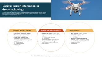
Various Sensor Integration In Drone Technology
This slide showcases sensor integration in drone technology which provides real time data and enables advanced obstacle detection capabilities. It includes elements such as speed sensor, distance sensor, infrared, thermal sensor and image sensor. Presenting our set of slides with Various Sensor Integration In Drone Technology. This exhibits information on three stages of the process. This is an easy to edit and innovatively designed PowerPoint template. So download immediately and highlight information on Speed And Distance Sensing, Infrared And Thermal Sensors, Image Sensors.
-
Role Of Remote Sensing In Epeirogeny PPT Template ACP
Present the topic in a bit more detail with this Role Of Remote Sensing In Epeirogeny PPT Template ACP. Use it as a tool for discussion and navigation on Geospatial Analysis, Earth Surface Dynamics, Tectonic Processes, Satellite Imagery. This template is free to edit as deemed fit for your organization. Therefore download it now.
-
SAR Systems For Earth Observation And Remote Sensing PPT Demonstration AT
Step up your game with our enchanting SAR Systems For Earth Observation And Remote Sensing PPT Demonstration AT deck, guaranteed to leave a lasting impression on your audience. Crafted with a perfect balance of simplicity, and innovation, our deck empowers you to alter it to your specific needs. You can also change the color theme of the slide to mold it to your companys specific needs. Save time with our ready made design, compatible with Microsoft versions and Google Slides. Additionally, its available for download in various formats including JPG, JPEG, and PNG. Outshine your competitors with our fully editable and customized deck.
-
Remote Sensing Technology Applications In Precision Farming Symbiotic Bond PPT Sample
Following slide represents remote sensing technology in precision agriculture that empower data driven decision making for sustainable crop growth. Present the topic in a bit more detail with this Remote Sensing Technology Applications In Precision Farming Symbiotic Bond PPT Sample. Use it as a tool for discussion and navigation on Remote Sensing, Technology Applications, Precision Farming. This template is free to edit as deemed fit for your organization. Therefore download it now.
-
Weather Forecasting Using Remote Sensing Technologies PPT PowerPoint AT
Ditch the Dull templates and opt for our engaging Weather Forecasting Using Remote Sensing Technologies PPT PowerPoint AT deck to attract your audience. Our visually striking design effortlessly combines creativity with functionality, ensuring your content shines through. Compatible with Microsoft versions and Google Slides, it offers seamless integration of presentation. Save time and effort with our pre-designed PPT layout, while still having the freedom to customize fonts, colors, and everything you ask for. With the ability to download in various formats like JPG, JPEG, and PNG, sharing your slides has never been easier. From boardroom meetings to client pitches, this deck can be the secret weapon to leaving a lasting impression.
-
Remote Sensing Applications In Agriculture PPT Slides AT
Step up your game with our enchanting Remote Sensing Applications In Agriculture PPT Slides AT deck, guaranteed to leave a lasting impression on your audience. Crafted with a perfect balance of simplicity, and innovation, our deck empowers you to alter it to your specific needs. You can also change the color theme of the slide to mold it to your companys specific needs. Save time with our ready-made design, compatible with Microsoft versions and Google Slides. Additionally, its available for download in various formats including JPG, JPEG, and PNG. Outshine your competitors with our fully editable and customized deck.
-
Radiomics Preprocessing Techniques And Methods PPT Summary AT
Ditch the Dull templates and opt for our engaging Radiomics Preprocessing Techniques And Methods PPT Summary AT deck to attract your audience. Our visually striking design effortlessly combines creativity with functionality, ensuring your content shines through. Compatible with Microsoft versions and Google Slides, it offers seamless integration of presentation. Save time and effort with our pre-designed PPT layout, while still having the freedom to customize fonts, colors, and everything you ask for. With the ability to download in various formats like JPG, JPEG, and PNG, sharing your slides has never been easier. From boardroom meetings to client pitches, this deck can be the secret weapon to leaving a lasting impression.
-
Satellite Remote Sensing For Earth Observation PPT Template AT
Do not compromise on a template that erodes your messages impact. Introducing our engaging Satellite Remote Sensing For Earth Observation PPT Template AT complete deck, thoughtfully crafted to grab your audiences attention instantly. With this deck, effortlessly download and adjust elements, streamlining the customization process. Whether you are using Microsoft versions or Google Slides, it fits seamlessly into your workflow. Furthermore, it is accessible in JPG, JPEG, PNG, and PDF formats, facilitating easy sharing and editing. Not only that you also play with the color theme of your slides making it suitable as per your audiences preference.
-
Overview Of Machine Vision Technologies Perception Systems PPT Slides ST AI SS
Deliver an outstanding presentation on the topic using this Overview Of Machine Vision Technologies Perception Systems PPT Slides ST AI SS. Dispense information and present a thorough explanation of Machine Vision, Perception Systems, Artificial Intelligence, Image Processing using the slides given. This template can be altered and personalized to fit your needs. It is also available for immediate download. So grab it now.
-
Sensor Integration Techniques PPT PowerPoint ST AI SS
Increase audience engagement and knowledge by dispensing information using Sensor Integration Techniques PPT PowerPoint ST AI SS. This template helps you present information on eight stages. You can also present information on Data Fusion, Sensor Networks, IoT Integration, Real-time Data Processing using this PPT design. This layout is completely editable so personaize it now to meet your audiences expectations.
-
Exploring Refractometry Techniques And Applications PPT Information AT
Ditch the Dull templates and opt for our engaging Exploring Refractometry Techniques And Applications PPT Information AT deck to attract your audience. Our visually striking design effortlessly combines creativity with functionality, ensuring your content shines through. Compatible with Microsoft versions and Google Slides, it offers seamless integration of presentation. Save time and effort with our pre-designed PPT layout, while still having the freedom to customize fonts, colors, and everything you ask for. With the ability to download in various formats like JPG, JPEG, and PNG, sharing your slides has never been easier. From boardroom meetings to client pitches, this deck can be the secret weapon to leaving a lasting impression.
-
Remote Sensing In Agriculture PPT Structure AT
Do not compromise on a template that erodes your messages impact. Introducing our engaging Remote Sensing In Agriculture PPT Structure AT complete deck, thoughtfully crafted to grab your audiences attention instantly. With this deck, effortlessly download and adjust elements, streamlining the customization process. Whether you are using Microsoft versions or Google Slides, it fits seamlessly into your workflow. Furthermore, it is accessible in JPG, JPEG, PNG, and PDF formats, facilitating easy sharing and editing. Not only that you also play with the color theme of your slides making it suitable as per your audiences preference.
-
Advances In Satellite Earth Remote Sensing Technologies PPT Graphics AT
Ditch the Dull templates and opt for our engaging Advances In Satellite Earth Remote Sensing Technologies PPT Graphics AT deck to attract your audience. Our visually striking design effortlessly combines creativity with functionality, ensuring your content shines through. Compatible with Microsoft versions and Google Slides, it offers seamless integration of presentation. Save time and effort with our pre designed PPT layout, while still having the freedom to customize fonts, colors, and everything you ask for. With the ability to download in various formats like JPG, JPEG, and PNG, sharing your slides has never been easier. From boardroom meetings to client pitches, this deck can be the secret weapon to leaving a lasting impression.
-
Remote Sensing For Disaster Management PPT Template AT
Step up your game with our enchanting Remote Sensing For Disaster Management PPT Template AT deck, guaranteed to leave a lasting impression on your audience. Crafted with a perfect balance of simplicity, and innovation, our deck empowers you to alter it to your specific needs. You can also change the color theme of the slide to mold it to your companys specific needs. Save time with our ready made design, compatible with Microsoft versions and Google Slides. Additionally, its available for download in various formats including JPG, JPEG, and PNG. Outshine your competitors with our fully editable and customized deck.