

Applications Of Remote Sensing Technology In Agriculture




Try Before you Buy Download Free Sample Product
 Impress Your
 Audience
 100%
100% Editable
 Save Hours
 of Time


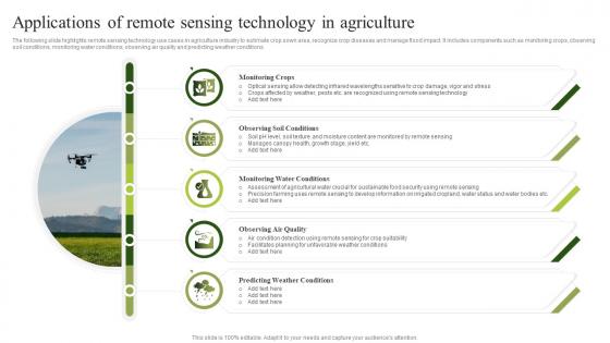
The following slide highlights remote sensing technology use cases in agriculture industry to estimate crop sown area, recognize crop diseases and manage flood impact. It includes components such as monitoring crops, observing soil conditions, monitoring water conditions, observing air quality and predicting weather conditions.
People who downloaded this PowerPoint presentation also viewed the following :
Applications Of Remote Sensing Technology In Agriculture with all 6 slides:
Use our Applications Of Remote Sensing Technology In Agriculture to effectively help you save your valuable time. They are readymade to fit into any presentation structure.






FAQs for Applications Of Remote Sensing
Satellites are probably your best starting point - Landsat and Sentinel let you track crop health across huge areas over time. Drones are everywhere now (literally every farm consultant has one lol). They're great for getting detailed shots when you need to check specific problem spots. Multispectral sensors are pretty cool - they pick up light wavelengths we can't see, so you'll spot nutrient issues or disease way before anything looks wrong visually. Hyperspectral ones do the same thing but even more precise. Honestly, if you're new to this stuff, just mess around with Google Earth Engine first since it's free satellite data.
Dude, remote sensing is honestly pretty cool - basically satellites and drones watching your crops so you don't have to walk every single field. What's wild is how it catches stuff way before you'd ever see it, like if your plants are stressed or getting hit by pests. The soil moisture data alone is super helpful. You can even get decent yield predictions weeks ahead of harvest, which blows my mind. I'd mess around with the free satellite data from USGS first - just to see what kind of info you can actually pull from your fields before investing in anything fancy.
Dude, satellites and drones are game-changers for farming. Satellites cover huge areas regularly - gives you that bird's eye view of everything. Drones? Way better for zeroing in on trouble spots with crazy detailed shots. Both catch nutrient problems, pest damage, irrigation issues way before you'd notice walking around. Honestly the coolest part is turning all that data into variable rate maps - tells you exactly where to spray or fertilize what. My buddy saved like 30% on inputs last season doing this. ROI comes from not wasting money treating healthy areas that don't need it.
So you can track soil health with satellites and drones - they pick up multispectral data showing organic matter, moisture, nutrients, all that stuff. Creates these detailed maps of your fields so you know exactly where problems are hiding. Pretty wild that we can spot soil issues from space now, honestly beats walking every acre. You'll catch nutrient deficiencies before they tank your yields. Plus the data works great for variable rate fertilizer application - no more guessing games. I've seen farmers save tons on inputs just by knowing which zones actually need treatment versus the areas that are doing fine.
Honestly, the money hits first - sensors and drones aren't cheap. Plus you'll need someone who actually knows how to read all that data, which is trickier than it sounds. Weather screws with everything too, like when clouds block your satellite shots right when you need them. Your team's gonna need time to figure it out, and good luck if your internet sucks out there. Oh, and don't go crazy trying to upgrade everything at once. Pick one thing first, maybe just crop monitoring. Way less overwhelming that way.
So multispectral captures like 3-10 bands while hyperspectral goes nuts with hundreds. For farming stuff, multispectral's honestly perfect - you'll get your NDVI readings, spot irrigation problems, basic crop health monitoring. Hyperspectral is insanely detailed (think detecting exact nutrient deficiencies), but man, the cost is brutal and those data files are absolutely massive. Your laptop will hate you. Most farmers I know just use multispectral drones or satellite data. Way more practical and you still get solid info without drowning in complexity or breaking the bank.
Dude, you've gotta try remote sensing for pest detection. Drones with multispectral cameras can spot stressed plants way before you'd see anything wrong walking around. Plants literally reflect light differently when they're getting attacked - it's wild how sensitive the tech is now. Different diseases have unique spectral fingerprints, so you can ID exactly what's hitting your crops and where it's spreading. Honestly beats the hell out of spraying everything and hoping for the best. Just fly regular monitoring runs during those sketchy growth periods when pests usually show up. Catching stuff early will save you serious cash.
So basically, remote sensing gives you crazy precise data about what's happening in your fields - no more guessing games. Instead of dumping fertilizer and water everywhere, you'll know exactly which spots need what. It's honestly pretty cool, like having superpowers for farming. Your chemical runoff drops, you waste less stuff, and you save money while your yields stay solid. Plus the satellite data tracks your soil health over time (though that part takes patience). I'd try it on just one field first to see how it changes how you make decisions.
Ugh, weather totally screws with remote sensing data. Clouds block everything obviously, but humidity and dust mess with light wavelengths too. After storms, I've seen healthy crops look absolutely terrible because wet soil appears darker and plants look stressed. Temperature changes throughout the day also shift how plants reflect light - it's annoying honestly. Multi-temporal data helps a ton though. Always check local weather station reports before you freak out about weird readings. Trust me, I've made that mistake before making big crop decisions.
So basically remote sensing lets you see exactly which parts of your fields need water instead of just blasting everything equally. Drones and satellites show you the moisture levels in real-time - honestly it's pretty game-changing once you get used to it. You can spot broken irrigation lines from above too, which saves a ton of headaches. Most farmers I know cut their water use by like 20-30% this way but still get the same yields. Oh, and you'll want to get those baseline moisture maps first before you start changing anything up.
Dude, remote sensing is actually a game changer for profits. Spot-treat your fields instead of blanket spraying everything - saves tons on fertilizer and pesticides. Water costs drop too since you're not guessing where to irrigate. Early problem detection is huge, stops small issues from becoming total disasters. The tech costs hurt upfront, I won't lie, but most guys break even in 2-3 seasons from better yields alone. Quality goes up too which helps prices. My buddy started with just drone mapping his best fields first - maybe try that approach before going all in?
So basically APIs and cloud platforms pull satellite/drone data straight into your farm software. Climate FieldView and Granular are solid options - they automatically grab NDVI maps, soil moisture, crop health stuff. Pretty smooth once it's running. The data creates variable rate maps for fertilizer/pesticides, predicts yields, handles irrigation timing. Oh and definitely check if your tractors can actually read the prescription maps first - learned that one the hard way! Most newer equipment works fine but older stuff can be finicky.
Dude, the computer vision stuff for farm imagery is getting insane. CNNs can spot crop diseases and estimate yields automatically now - saves tons of time vs doing it by hand. They're even nailing individual plant detection and predicting when to harvest. What blows my mind is how they process multispectral data that we can't even see, catching stress signs super early. Honestly didn't think we'd get here this fast. Google Earth Engine has some solid ML APIs if you want to mess around with it - way easier than I expected to get running.
So basically remote sensing lets you see your fields from above over several seasons - kinda like watching a movie of your farm. You can track what you planted where and how different areas performed. I'd start by pulling satellite data from the last 3-5 years to spot patterns. Some sections might need nitrogen-fixing legumes, others could use a break from heavy crops. The moisture and yield data shows you which spots are underperforming too. My neighbor swears by this approach - says it's way better than just guessing where to rotate next season.
Honestly, the biggest red flag is who gets to keep your farm data and what they do with it behind your scenes. Companies grab way more intel than you'd expect - yield numbers, field layouts, how you operate, even financial stuff. Some are pretty shady about their policies too. Competitors might get access, insurance could screw you over with it, or they'll just sell your info to whoever pays. I'd definitely dig into those terms before signing anything. Ask them straight up about ownership and where they store everything. Trust me, that fine print matters more than you think when it's your livelihood on the line.
-
Amazing variety of PowerPoint slides. Really helpful in designing professional presentations.
-
One-stop solution for all presentation needs. Great products with easy customization.