Powerpoint Templates and Google slides for Remote Sensing
Save Your Time and attract your audience with our fully editable PPT Templates and Slides.
-
Normalized Difference Vegetation Index Remote Sensing Vegetation PPT Example ST AI
Step up your game with our enchanting Normalized Difference Vegetation Index Remote Sensing Vegetation PPT Example ST AI deck, guaranteed to leave a lasting impression on your audience. Crafted with a perfect balance of simplicity, and innovation, our deck empowers you to alter it to your specific needs. You can also change the color theme of the slide to mold it to your companys specific needs. Save time with our ready-made design, compatible with Microsoft versions and Google Slides. Additionally, its available for download in various formats including JPG, JPEG, and PNG. Outshine your competitors with our fully editable and customized deck.
-
Exploring Multispectral Remote Sensing Techniques For Analysis PPT PowerPoint ST AI
Ditch the Dull templates and opt for our engaging Exploring Multispectral Remote Sensing Techniques For Analysis PPT PowerPoint ST AI deck to attract your audience. Our visually striking design effortlessly combines creativity with functionality, ensuring your content shines through. Compatible with Microsoft versions and Google Slides, it offers seamless integration of presentation. Save time and effort with our pre-designed PPT layout, while still having the freedom to customize fonts, colors, and everything you ask for. With the ability to download in various formats like JPG, JPEG, and PNG, sharing your slides has never been easier. From boardroom meetings to client pitches, this deck can be the secret weapon to leaving a lasting impression.
-
Landsat Earth Observation Satellite Remote Sensing Ppt Presentation ST AI
Ditch the Dull templates and opt for our engaging Landsat Earth Observation Satellite Remote Sensing Ppt Presentation ST AI deck to attract your audience. Our visually striking design effortlessly combines creativity with functionality, ensuring your content shines through. Compatible with Microsoft versions and Google Slides, it offers seamless integration of presentation. Save time and effort with our pre designed PPT layout, while still having the freedom to customize fonts, colors, and everything you ask for. With the ability to download in various formats like JPG, JPEG, and PNG, sharing your slides has never been easier. From boardroom meetings to client pitches, this deck can be the secret weapon to leaving a lasting impression.
-
Remote Sensing Of Glaciers Altimetry PPT Slides ACP
Dont compromise on a template that erodes your messages impact. Introducing our engaging Remote Sensing Of Glaciers Altimetry PPT Slides ACP complete deck, thoughtfully crafted to grab your audiences attention instantly. With this deck, effortlessly download and adjust elements, streamlining the customization process. Whether youre using Microsoft versions or Google Slides, it fits seamlessly into your workflow. Furthermore, its accessible in JPG, JPEG, PNG, and PDF formats, facilitating easy sharing and editing. Not only that you also play with the color theme of your slides making it suitable as per your audiences preference.
-
Radar Altimetry Remote Sensing PPT PowerPoint ACP
Ditch the Dull templates and opt for our engaging Radar Altimetry Remote Sensing PPT PowerPoint ACP deck to attract your audience. Our visually striking design effortlessly combines creativity with functionality, ensuring your content shines through. Compatible with Microsoft versions and Google Slides, it offers seamless integration of presentation. Save time and effort with our pre designed PPT layout, while still having the freedom to customize fonts, colors, and everything you ask for. With the ability to download in various formats like JPG, JPEG, and PNG, sharing your slides has never been easier. From boardroom meetings to client pitches, this deck can be the secret weapon to leaving a lasting impression.
-
AgTech Solutions Enhancing Applications Of Remote Sensing Technology Ppt Presentation
The following slide showcases various applications and use cases of remote sensing technologies in precision farming practices. It includes components such as area estimation, production forecasting, soli mapping, water management, etc. Introducing AgTech Solutions Enhancing Applications Of Remote Sensing Technology Ppt Presentation to increase your presentation threshold. Encompassed with four stages, this template is a great option to educate and entice your audience. Dispence information on Water Management, Production Forecasting, Technology In Agriculture, using this template. Grab it now to reap its full benefits.
-
AgTech Solutions Enhancing Impact Of Remote Sensing Technology In Agriculture Ppt Slides
The following slide highlights positive impact of adopting remote sensing technologies in agricultural practices. It includes components such as crop production, water consumption, soil health, overall costs, labor hours, etc. Present the topic in a bit more detail with this AgTech Solutions Enhancing Impact Of Remote Sensing Technology In Agriculture Ppt Slides. Use it as a tool for discussion and navigation on Crop Production, Water Consumption, Sensing Technology In Agriculture. This template is free to edit as deemed fit for your organization. Therefore download it now.
-
AgTech Solutions Enhancing Working Process Of Remote Sensing Technology In Farming Ppt Slides
The following slide depicts workflow process of remote sensing in precision farming to gather data from satellites. It includes steps such as identifying energy sources, connecting with target, detecting sensors, acquiring data, etc. Introducing AgTech Solutions Enhancing Working Process Of Remote Sensing Technology In Farming Ppt Slides to increase your presentation threshold. Encompassed with four stages, this template is a great option to educate and entice your audience. Dispence information on Remote Sensing Technology, Farming Practices, Sensor Detection, Data Acquisition, using this template. Grab it now to reap its full benefits.
-
Space Radar Remote Sensing Colored Icon In Powerpoint Pptx Png And Editable Eps Format
This coloured powerpoint icon is perfect for presentations about space exploration. It features a radar dish with a rocket in the background, representing the search for new worlds and the possibilities of space. It is sure to make your presentation stand out.
-
Space Radar Remote Sensing Monotone Icon In Powerpoint Pptx Png And Editable Eps Format
A Monotone powerpoint icon on Space Radar is a simple yet powerful graphic element to enhance your presentation. It features a sleek, modern design with a single color palette that is perfect for creating a professional and captivating presentation. It is easy to customize and can be used to illustrate any concept related to space.
-
Remote Sensing Farm Eye Colored Icon In Powerpoint Pptx Png And Editable Eps Format
This colourful PowerPoint icon is from the Smart Farm Eye collection. It depicts a modern farm with a watchful eye, representing the importance of monitoring and maintaining a healthy farm. Perfect for presentations on modern agriculture and the use of technology in farming.
-
Remote Sensing Farm Eye Monotone Icon In Powerpoint Pptx Png And Editable Eps Format
This Monotone PowerPoint Icon is perfect for presentations on Smart Farm Eye technology. It features a modern, sleek design with an eye catching blue and white color scheme. It will help to illustrate the concept of Smart Farm Eye and is sure to impress your audience
-
Motion Sensors Technology IoT Remote Asset Monitoring And Management IoT SS
This slide provides an overview of the motion sensor technology used by house owners. It further includes its working and factors to consider while selecting motion sensors that are reliability, range, pet immunity, battery life, repones time and installation. Increase audience engagement and knowledge by dispensing information using Motion Sensors Technology IoT Remote Asset Monitoring And Management IoT SS. This template helps you present information on four stages. You can also present information on Features, Working, Consideration using this PPT design. This layout is completely editable so personaize it now to meet your audiences expectations.
-
Senseye PDM Solution Used To IoT Remote Asset Monitoring And Management IoT SS
This slide provides an overview of the cloud based predictive maintenance solution that offers multiple services. The slide further includes its benefits and features that are asset lifecycle management, downtime tracking, historical reporting and trend analysis. Deliver an outstanding presentation on the topic using this Senseye PDM Solution Used To IoT Remote Asset Monitoring And Management IoT SS. Dispense information and present a thorough explanation of Improves, Machine, Maintenance using the slides given. This template can be altered and personalized to fit your needs. It is also available for immediate download. So grab it now.
-
Smart Home Water Sensors IoT Remote Asset Monitoring And Management IoT SS
This slide provides an overview of the smart home water sensors used to avoid leakage and prevent damage to property. The slide includes advantages that are easy installation, low maintenance and power consumption. Introducing Smart Home Water Sensors IoT Remote Asset Monitoring And Management IoT SS to increase your presentation threshold. Encompassed with two stages, this template is a great option to educate and entice your audience. Dispence information on Sensors, Suitable, Working, using this template. Grab it now to reap its full benefits.
-
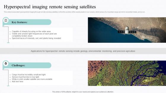
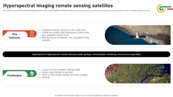
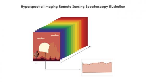
Spectral Signature Analysis Hyperspectral Imaging Remote Sensing Satellites
This slide incorporate hyperspectral imaging through remote sensing satellites, to find the position of the waste plastic in our oceans, which areas of a mountain range are rich in essential metals, and so on. Present the topic in a bit more detail with this Spectral Signature Analysis Hyperspectral Imaging Remote Sensing Satellites Use it as a tool for discussion and navigation on Hyperspectral, Environmental Monitoring, Precision Agriculture This template is free to edit as deemed fit for your organization. Therefore download it now.
-
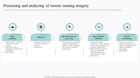
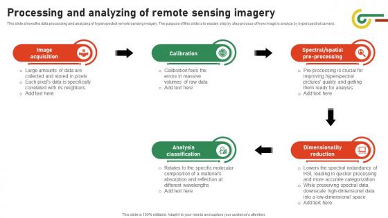
Spectral Signature Analysis Processing And Analyzing Of Remote Sensing Imagery
This slide shows the data processing and analyzing of hyperspectral remote sensing imagery. The purpose of this slide is to explain step by step process of how image is analyze by hyperspectral camera. Introducing Spectral Signature Analysis Processing And Analyzing Of Remote Sensing Imagery to increase your presentation threshold. Encompassed with five stages, this template is a great option to educate and entice your audience. Dispence information on Image Acquisition, Calibration, Dimensionality Reduction using this template. Grab it now to reap its full benefits.
-
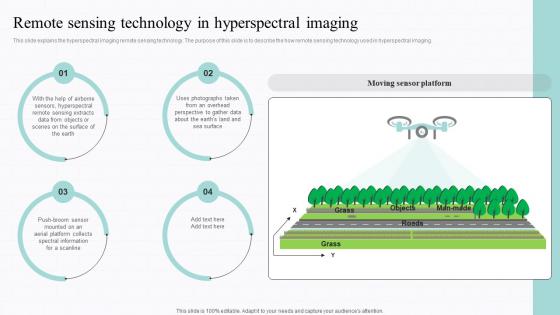
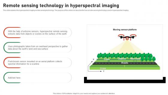
Spectral Signature Analysis Remote Sensing Technology In Hyperspectral Imaging
This slide explains the hyperspectral imaging remote sensing technology. The purpose of this slide is to describe the how remote sensing technology used in hyperspectral imaging. Present the topic in a bit more detail with this Spectral Signature Analysis Remote Sensing Technology In Hyperspectral Imaging Use it as a tool for discussion and navigation on Technology, Hyperspectral Imaging, Photographs This template is free to edit as deemed fit for your organization. Therefore download it now.
-
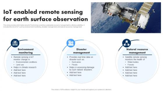
Remote Sensing System To Monitor Accelerating Business Digital Transformation DT SS
This slide covers IoT based remote sensing technology to gather surface information. It involves major applications such as soil mapping, environmental monitoring, disaster management and mineral and resource exploration. Increase audience engagement and knowledge by dispensing information using Remote Sensing System To Monitor Accelerating Business Digital Transformation DT SS. This template helps you present information on five stages. You can also present information on Environmental, Management, Resource using this PPT design. This layout is completely editable so personaize it now to meet your audiences expectations.
-
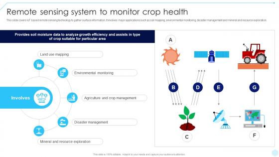
IoT Enabled Remote Sensing For Earth Surface Extending IoT Technology Applications IoT SS
This slide provides information about IoT technology enabling sustainable resource management by utilizing satellites. It includes the role of IoT such as environment monitoring, disaster management, and natural resources management. Increase audience engagement and knowledge by dispensing information using IoT Enabled Remote Sensing For Earth Surface Extending IoT Technology Applications IoT SS. This template helps you present information on three stages. You can also present information on Environment Monitoring, Disaster Management, Natural Resource Management using this PPT design. This layout is completely editable so personaize it now to meet your audiences expectations.
-
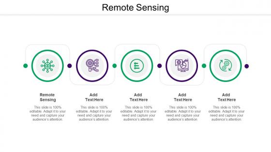
Multiple Applications Of Remote Sensing Geospatial Technology For Environment Conservation TC SS
This slide provides glimpse about different applications of remote sensing that help in boosting agricultural productivity. It includes applications such as field surveys, aerial photography, light detection and ranging, etc. Introducing Multiple Applications Of Remote Sensing Geospatial Technology For Environment Conservation TC SS to increase your presentation threshold. Encompassed with five stages, this template is a great option to educate and entice your audience. Dispence information on Aerial Photography, Data Scanning And Digitization, Field Surveys, using this template. Grab it now to reap its full benefits.
-
Remote Sensing Overview For Collecting Geospatial Technology For Environment Conservation TC SS
This slide provides glimpse about summary of remote sensing that helps in collection and analysis of geographic data. It includes types of remote sensing such as active remote sensing, passive remote sensing, etc. Deliver an outstanding presentation on the topic using this Remote Sensing Overview For Collecting Geospatial Technology For Environment Conservation TC SS. Dispense information and present a thorough explanation of Types Of Remote Sensing, Active Remote Sensing, Passive Remote Sensing using the slides given. This template can be altered and personalized to fit your needs. It is also available for immediate download. So grab it now.
-
Using Remote Sensing For Disaster Management Geospatial Technology For Environment Conservation TC SS
This slide provides glimpse about utilizing remote sensing technologies that can help in collecting satellite imagery for disaster management. It includes advantages such as damage assessment, etc. Increase audience engagement and knowledge by dispensing information using Using Remote Sensing For Disaster Management Geospatial Technology For Environment Conservation TC SS. This template helps you present information on four stages. You can also present information on Damage Assessment, Transportation Planning, Early Warning And Monitoring using this PPT design. This layout is completely editable so personaize it now to meet your audiences expectations.
-
Spatial Analysis And Remote Sensing In Ppt Powerpoint Presentation Slide Templates Cpp
Presenting Spatial Analysis And Remote Sensing In Ppt Powerpoint Presentation Slide Templates Cpp slide which is completely adaptable. The graphics in this PowerPoint slide showcase four stages that will help you succinctly convey the information. In addition, you can alternate the color, font size, font type, and shapes of this PPT layout according to your content. This PPT presentation can be accessed with Google Slides and is available in both standard screen and widescreen aspect ratios. It is also a useful set to elucidate topics like Spatial Analysis And Remote Sensing. This well-structured design can be downloaded in different formats like PDF, JPG, and PNG. So, without any delay, click on the download button now.
-
Evapotranspiration Remote Sensing Ppt Slides Cpp
Presenting Evapotranspiration Remote Sensing Ppt Slides Cpp slide which is completely adaptable. The graphics in this PowerPoint slide showcase four stages that will help you succinctly convey the information. In addition, you can alternate the color, font size, font type, and shapes of this PPT layout according to your content. This PPT presentation can be accessed with Google Slides and is available in both standard screen and widescreen aspect ratios. It is also a useful set to elucidate topics like Evapotranspiration Remote Sensing. This well structured design can be downloaded in different formats like PDF, JPG, and PNG. So, without any delay, click on the download button now.
-
Anisotropic Scattering Land Remote Sensing Ppt Slides Cpp
Presenting our Anisotropic Scattering Land Remote Sensing Ppt Slides Cpp PowerPoint template design. This PowerPoint slide showcases four stages. It is useful to share insightful information on Anisotropic Scattering Land Remote Sensing This PPT slide can be easily accessed in standard screen and widescreen aspect ratios. It is also available in various formats like PDF, PNG, and JPG. Not only this, the PowerPoint slideshow is completely editable and you can effortlessly modify the font size, font type, and shapes according to your wish. Our PPT layout is compatible with Google Slides as well, so download and edit it as per your knowledge.
-
Smart Dust Future Of Remote Sensing In Powerpoint And Google Slides Cpp
Presenting Smart Dust Future Of Remote Sensing In Powerpoint And Google Slides Cpp slide which is completely adaptable. The graphics in this PowerPoint slide showcase eight stages that will help you succinctly convey the information. In addition, you can alternate the color, font size, font type, and shapes of this PPT layout according to your content. This PPT presentation can be accessed with Google Slides and is available in both standard screen and widescreen aspect ratios. It is also a useful set to elucidate topics like Smart Dust Future Of Remote Sensing. This well-structured design can be downloaded in different formats like PDF, JPG, and PNG. So, without any delay, click on the download button now.
-
Smart Dust Remote Sensing In Powerpoint And Google Slides Cpp
Presenting our Smart Dust Remote Sensing In Powerpoint And Google Slides Cpp PowerPoint template design. This PowerPoint slide showcases four stages. It is useful to share insightful information on Smart Dust Remote Sensing This PPT slide can be easily accessed in standard screen and widescreen aspect ratios. It is also available in various formats like PDF, PNG, and JPG. Not only this, the PowerPoint slideshow is completely editable and you can effortlessly modify the font size, font type, and shapes according to your wish. Our PPT layout is compatible with Google Slides as well, so download and edit it as per your knowledge.
-
Planetary Geology And Remote Sensing Ppt Sample Cpp
Presenting our Planetary Geology And Remote Sensing Ppt Sample Cpp PowerPoint template design. This PowerPoint slide showcases four stages. It is useful to share insightful information on Planetary Geology And Remote Sensing This PPT slide can be easily accessed in standard screen and widescreen aspect ratios. It is also available in various formats like PDF, PNG, and JPG. Not only this, the PowerPoint slideshow is completely editable and you can effortlessly modify the font size, font type, and shapes according to your wish. Our PPT layout is compatible with Google Slides as well, so download and edit it as per your knowledge.
-
Data Image Processing In Remote Sensing Ppt Presentation
The purpose of this slide is to explore data image processing applications in remote sensing, highlighting its role in environmental monitoring and analysis. Elements in the slide are geometric correction, change detection, etc. Presenting our well structured Data Image Processing In Remote Sensing Ppt Presentation. The topics discussed in this slide are Geometric Correction, Change Detection, Mosaicking, Noise Reduction. This is an instantly available PowerPoint presentation that can be edited conveniently. Download it right away and captivate your audience.
-
Geologic Remote Sensing Planetary PPT Template CPP
Presenting our Geologic Remote Sensing Planetary PPT Template CPP PowerPoint template design. This PowerPoint slide showcases five stages. It is useful to share insightful information on Geologic Remote Sensing Planetary. This PPT slide can be easily accessed in standard screen and widescreen aspect ratios. It is also available in various formats like PDF, PNG, and JPG. Not only this, the PowerPoint slideshow is completely editable and you can effortlessly modify the font size, font type, and shapes according to your wish. Our PPT layout is compatible with Google Slides as well, so download and edit it as per your knowledge.
-
Remote Sensing For Site Detection Geoarchaeology PPT Mockup ST AI SS
Deliver an outstanding presentation on the topic using this Remote Sensing For Site Detection Geoarchaeology PPT Mockup ST AI SS. Dispense information and present a thorough explanation of Geospatial Analysis, Satellite Imagery, Aerial Surveying using the slides given. This template can be altered and personalized to fit your needs. It is also available for immediate download. So grab it now.
-
Remote Cardiac Activity Monitoring Sensor Icon Ppt Powerpoint
Presenting our well structured Remote Cardiac Activity Monitoring Sensor Icon Ppt Powerpoint. The topics discussed in this slide are Remote Cardiac Activity Monitoring Sensor. This is an instantly available PowerPoint presentation that can be edited conveniently. Download it right away and captivate your audience.
-
In Situ Vs Remote Sensing Pros And Cons Biosignature PPT Template ACP
Present the topic in a bit more detail with this In Situ Vs Remote Sensing Pros And Cons Biosignature PPT Template ACP Use it as a tool for discussion and navigation on Data Collection Methods, Geospatial Analysis, Environmental Monitoring This template is free to edit as deemed fit for your organization. Therefore download it now.
-
Remote Sensing In Agrometeorology PPT Example ST AI SS
Deliver an outstanding presentation on the topic using this Remote Sensing In Agrometeorology PPT Example ST AI SS. Dispense information and present a thorough explanation of Precision Agriculture, Satellite Imagery, Climate Data Analysis, Crop Monitoring using the slides given. This template can be altered and personalized to fit your needs. It is also available for immediate download. So grab it now.
-
Role Of Polarization In Remote Sensing Polarization Cross Scattering PPT Example ST AI SS
Increase audience engagement and knowledge by dispensing information using Role Of Polarization In Remote Sensing Polarization Cross Scattering PPT Example ST AI SS. This template helps you present information on eight stages. You can also present information on Polarimetric Imaging, Remote Sensing Techniques, Scattering Mechanisms, Microwave Polarization, Synthetic Aperture Radar, Electromagnetic Waves using this PPT design. This layout is completely editable so personaize it now to meet your audiences expectations.
-
Remote Sensing In Crop Phenotyping PPT Sample ST AI SS
Deliver an outstanding presentation on the topic using this Remote Sensing In Crop Phenotyping PPT Sample ST AI SS. Dispense information and present a thorough explanation of Crop Monitoring, Precision Agriculture, Remote Sensing Technology, Phenotypic Analysis, Agricultural Data Analytics, Satellite Imagery using the slides given. This template can be altered and personalized to fit your needs. It is also available for immediate download. So grab it now.
-
Ethical Considerations In Remote Sensing Normalized Difference Vegetation Index PPT Slides ST AI SS
Deliver an outstanding presentation on the topic using this Ethical Considerations In Remote Sensing Normalized Difference Vegetation Index PPT Slides ST AI SS. Dispense information and present a thorough explanation of Remote Sensing Ethics, NDVI Applications, Environmental Monitoring, Data Privacy in Remote Sensing, Satellite Imagery Ethics, Sustainable Development Goals using the slides given. This template can be altered and personalized to fit your needs. It is also available for immediate download. So grab it now.
-
Future Directions For Remote Sensing Vegetation Analysis Normalized Difference Vegetation Index ST AI SS
Increase audience engagement and knowledge by dispensing information using Future Directions For Remote Sensing Vegetation Analysis Normalized Difference Vegetation Index ST AI SS. This template helps you present information on four stages. You can also present information on Vegetation Monitoring, Remote Sensing Technologies, Machine Learning in Ecology, Satellite Imagery Analysis, Land Cover Classification, Vegetation Health Assessment using this PPT design. This layout is completely editable so personaize it now to meet your audiences expectations.
-
Integration Of NDVI With Other Remote Sensing Data Normalized Difference Vegetation Index ST AI SS
Increase audience engagement and knowledge by dispensing information using Integration Of NDVI With Other Remote Sensing Data Normalized Difference Vegetation Index ST AI SS. This template helps you present information on four stages. You can also present information on Remote Sensing, Vegetation Analysis, Satellite Imagery, Land Cover Classification, Multispectral Data, Environmental Monitoring using this PPT design. This layout is completely editable so personaize it now to meet your audiences expectations.
-
Remote Sensing Applications In Evapotranspiration Studies Ppt Template ST AI SS
Introducing Remote Sensing Applications In Evapotranspiration Studies Ppt Template ST AI SS to increase your presentation threshold. Encompassed with eight stages, this template is a great option to educate and entice your audience. Dispence information on Remote Sensing, Evapotranspiration Measurement, Satellite Imagery, Data Analysis, using this template. Grab it now to reap its full benefits.
-
Remote Sensing In Geomorphological Studies PPT Presentation ST AI SS
Increase audience engagement and knowledge by dispensing information using Remote Sensing In Geomorphological Studies PPT Presentation ST AI SS. This template helps you present information on three stages. You can also present information on Geospatial Analysis, Terrain Mapping, Satellite Imagery, Geographic Information Systems, Landform Classification, Environmental Monitoring using this PPT design. This layout is completely editable so personaize it now to meet your audiences expectations.
-
Integrating Remote Sensing For Environmental Management Harnessing AI Ppt Slides
Following slide represents applications of integrating remote sensing technique for environment monitoring and better planning. It incudes pointers such as researching tool, infrastructure management, etc. Introducing Integrating Remote Sensing For Environmental Management Harnessing AI Ppt Slides to increase your presentation threshold. Encompassed with three stages, this template is a great option to educate and entice your audience. Dispense information on Satellite Imaging For Monitoring, Infrastructure Management, Researching Tool, using this template. Grab it now to reap its full benefits.
-
Radiometric Techniques In Remote Sensing PPT PowerPoint ST AI SS
Deliver an outstanding presentation on the topic using this Radiometric Techniques In Remote Sensing PPT PowerPoint ST AI SS. Dispense information and present a thorough explanation of Remote Sensing, Radiometric Calibration, Image Processing, Spectral Analysis using the slides given. This template can be altered and personalized to fit your needs. It is also available for immediate download. So grab it now.
-
Remote Sensing And Data Sharing Policies Space Policy PPT Presentation ST AI SS
Deliver an outstanding presentation on the topic using this Remote Sensing And Data Sharing Policies Space Policy PPT Presentation ST AI SS Dispense information and present a thorough explanation of Satellite Data Governance, Open Data Initiatives, Earth Observation Regulations, Geospatial Data Accessibility using the slides given. This template can be altered and personalized to fit your needs. It is also available for immediate download. So grab it now.
-
Remote Sensing Applications In Farming GIS In Agriculture PPT Template ST AI SS
Present the topic in a bit more detail with this Remote Sensing Applications In Farming GIS In Agriculture PPT Template ST AI SS. Use it as a tool for discussion and navigation on Precision Agriculture, Geographic Information Systems, Agricultural Data Analysis, Remote Sensing Technology, Crop Monitoring. This template is free to edit as deemed fit for your organization. Therefore download it now.
-
Remote Sensing Technology Applications In Precision Farming Symbiotic Bond PPT Sample
Following slide represents remote sensing technology in precision agriculture that empower data driven decision making for sustainable crop growth. Present the topic in a bit more detail with this Remote Sensing Technology Applications In Precision Farming Symbiotic Bond PPT Sample. Use it as a tool for discussion and navigation on Remote Sensing, Technology Applications, Precision Farming. This template is free to edit as deemed fit for your organization. Therefore download it now.
-
International Collaborations In Remote Sensing Landsat PPT Slides ST AI SS
Present the topic in a bit more detail with this International Collaborations In Remote Sensing Landsat PPT Slides ST AI SS. Use it as a tool for discussion and navigation on Remote Sensing, Landsat Satellite, International Partnerships, Geospatial Analysis. This template is free to edit as deemed fit for your organization. Therefore download it now.
-
Understanding Remote Sensing Principles Landsat PPT Sample ST AI SS
Present the topic in a bit more detail with this Understanding Remote Sensing Principles Landsat PPT Sample ST AI SS. Use it as a tool for discussion and navigation on Remote Sensing, Landsat Imagery, Geospatial Data, Satellite Data Analysis. This template is free to edit as deemed fit for your organization. Therefore download it now.
-
Integration With Other Remote Sensing Systems Synthetic Aperture Radar PPT Slides ST AI SS
Present the topic in a bit more detail with this Integration With Other Remote Sensing Systems Synthetic Aperture Radar PPT Slides ST AI SS. Use it as a tool for discussion and navigation on Remote Sensing Data Fusion, SAR Data Processing, Geospatial Metadata Standards, Machine Learning in Remote Sensing. This template is free to edit as deemed fit for your organization. Therefore download it now.
-
Remote Sensing Applications Regenerative Farming Practices Ppt Presentation
Following slide represents key applications of remote sensing in rainwater harvesting system. It includes elements such as precipitation monitoring, flood control, etc.Present the topic in a bit more detail with this Remote Sensing Applications Regenerative Farming Practices Ppt Presentation. Use it as a tool for discussion and navigation on Remote Sensing Applications, Precipitation Monitoring, Water Quality Assessment. This template is free to edit as deemed fit for your organization. Therefore download it now.
-
Team Of Experts In Remote Sensing And Geospatial Innovative Landsat Solutions Ppt Template
The following slide showcases our team of specialists in remote sensing and geospatial technologies. It highlights their expertise and the advanced skills they bring to deliver high-quality solutions and insights to our clients. Increase audience engagement and knowledge by dispensing information using Team Of Experts In Remote Sensing And Geospatial Innovative Landsat Solutions Ppt Template This template helps you present information on five stages. You can also present information on Senior Geospatial Analyst, Geospatial Technologies using this PPT design. This layout is completely editable so personaize it now to meet your audiences expectations.
-
Remote Sensing Ppt Powerpoint Presentation Styles Picture Cpb
Presenting our Remote Sensing Ppt Powerpoint Presentation Styles Picture Cpb PowerPoint template design. This PowerPoint slide showcases five stages. It is useful to share insightful information on Remote Sensing This PPT slide can be easily accessed in standard screen and widescreen aspect ratios. It is also available in various formats like PDF, PNG, and JPG. Not only this, the PowerPoint slideshow is completely editable and you can effortlessly modify the font size, font type, and shapes according to your wish. Our PPT layout is compatible with Google Slides as well, so download and edit it as per your knowledge.
-
Climate Analysis Remote Sensors Colored Icon In Powerpoint Pptx Png And Editable Eps Format
Give your next presentation a sophisticated, yet modern look with this 100 percent editable Climate analysis remote sensors colored icon in powerpoint pptx png and editable eps format. Choose from a variety of customizable formats such as PPTx, png, eps. You can use these icons for your presentations, banners, templates, One-pagers that suit your business needs.
-
Climate Analysis Remote Sensors Monotone Icon In Powerpoint Pptx Png And Editable Eps Format
Make your presentation profoundly eye-catching leveraging our easily customizable Climate analysis remote sensors monotone icon in powerpoint pptx png and editable eps format. It is designed to draw the attention of your audience. Available in all editable formats, including PPTx, png, and eps, you can tweak it to deliver your message with ease.
-
Remote Sensors Colored Icon In Powerpoint Pptx Png And Editable Eps Format
Give your next presentation a sophisticated, yet modern look with this 100 percent editable Remote sensors colored icon in powerpoint pptx png and editable eps format. Choose from a variety of customizable formats such as PPTx, png, eps. You can use these icons for your presentations, banners, templates, One-pagers that suit your business needs.
-
Remote Sensors Monotone Icon In Powerpoint Pptx Png And Editable Eps Format
Make your presentation profoundly eye-catching leveraging our easily customizable Remote sensors monotone icon in powerpoint pptx png and editable eps format. It is designed to draw the attention of your audience. Available in all editable formats, including PPTx, png, and eps, you can tweak it to deliver your message with ease.
-
Space Remote Sensors Colored Icon In Powerpoint Pptx Png And Editable Eps Format
Give your next presentation a sophisticated, yet modern look with this 100 percent editable Space remote sensors colored icon in powerpoint pptx png and editable eps format. Choose from a variety of customizable formats such as PPTx, png, eps. You can use these icons for your presentations, banners, templates, One-pagers that suit your business needs.
-
Space Remote Sensors Monotone Icon In Powerpoint Pptx Png And Editable Eps Format
Make your presentation profoundly eye-catching leveraging our easily customizable Space remote sensors monotone icon in powerpoint pptx png and editable eps format. It is designed to draw the attention of your audience. Available in all editable formats, including PPTx, png, and eps, you can tweak it to deliver your message with ease.
-
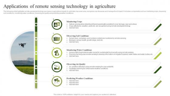
Applications Of Remote Sensing Technology In Agriculture
The following slide highlights remote sensing technology use cases in agriculture industry to estimate crop sown area, recognize crop diseases and manage flood impact. It includes components such as monitoring crops, observing soil conditions, monitoring water conditions, observing air quality and predicting weather conditions. Presenting our set of slides with Applications Of Remote Sensing Technology In Agriculture. This exhibits information on five stages of the process. This is an easy to edit and innovatively designed PowerPoint template. So download immediately and highlight information on Monitoring Crops, Observing Soil Conditions, Monitoring Water Conditions.