


Drone And Agriculture Powerpoint Ppt Template Bundles




Try Before you Buy Download Free Sample Product
 Impress Your
 Audience
 100%
100% Editable
 Save Hours
 of Time


Our Drone And Agriculture Powerpoint Ppt Template Bundles are topically designed to provide an attractive backdrop to any subject. Use them to look like a presentation pro.
People who downloaded this PowerPoint presentation also viewed the following :
Drone And Agriculture Powerpoint Ppt Template Bundles with all 19 slides:
Use our Drone And Agriculture Powerpoint Ppt Template Bundles to effectively help you save your valuable time. They are readymade to fit into any presentation structure.








FAQs for Drone And Agriculture Powerpoint
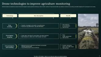
Honestly, drones are pretty game-changing for farming. You can spot pest problems and nutrient issues way before they get out of hand just from the aerial shots. The precision spraying is wild - uses way less chemicals so you're saving money there. My buddy says the data collection stuff is huge too, helps you figure out soil conditions and when plants actually need attention. Time savings are insane if you've got big fields to cover. I mean, beats walking around for hours trying to check everything manually. Worth looking into for sure.
Honestly, drones are pretty sweet for farming. You get this aerial view that shows problems way before you'd spot them walking around - like plant stress or disease that only shows up in infrared first. Multispectral cameras catch all that invisible stuff. Plus you can map exactly where issues are instead of just guessing and spraying your whole field. I'd probably start with just a basic camera drone first though, see how you like it. Even regular aerial shots reveal more than you'd think. The yield tracking over time is useful too, and fertilizer costs go down when you're not covering areas that don't need it.
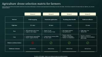
So most ag drones come with multispectral cameras, RGB cameras, thermal sensors, and sometimes LiDAR. Multispectral is where you'll want to start - it sees beyond what we can to check crop health and spot nutrient issues. Thermal's great for catching irrigation problems or disease early. LiDAR does the fancy 3D mapping stuff. Honestly, the hyperspectral sensors are cool but they'll destroy your budget. I'd go basic multispectral first and see what you actually need from there. No point dropping serious cash until you know what problems you're actually trying to solve, you know?
Honestly, drones are a game-changer for irrigation stuff. Thermal cameras show you exactly which spots are getting too much or too little water - the heat signatures don't lie. You can also use multispectral imaging to catch crop stress before it gets bad. Instead of watering everything the same, you adjust each zone based on what it actually needs. Saves water, saves money, better yields. Pretty solid win all around. I'd start by flying over your fields at different growth stages to get a feel for the patterns. Takes some getting used to but the data is surprisingly clear once you know what you're looking at.
So drones with those fancy multispectral cameras can catch pest problems way before you'd ever notice walking around. They pick up stress patterns and early disease symptoms that are invisible to us. Pretty wild how the thermal imaging shows temperature differences where issues are starting. You'll cover huge areas in minutes vs hours of trudging through fields - honestly game-changing if you ask me. Plus the data helps you spray only problem spots instead of dousing everything. I'd set up regular flights during growing season since catching stuff early saves you tons of headache later.
So drones are actually pretty cool for this - they fly over with special cameras that detect soil moisture, pH, and nutrient levels across your whole field. Way better than the old "walk around and grab random samples" approach (though my uncle still does that lol). You get these color-coded maps showing exactly where problems are. Then you can apply fertilizer or lime only where it's needed instead of dumping it everywhere. Honestly saves a ton of money and your crops do way better. Takes like one flight vs weeks of manual testing.
Drones are seriously game-changing for yield predictions. The multispectral cameras pick up crop stress and health patterns you'd never spot walking the field - it's wild how obvious problem areas look from up there. I'd grab data throughout the growing season, then match it against your past yield maps and weather records. The correlation is usually pretty solid once you dial it in. Oh, and definitely test on just one field first - learned that the hard way trying to do everything at once. You'll get way better at reading the vegetation indices with practice.
First things first - you gotta get your Remote Pilot Certificate under Part 107. Register your drone too (as long as it's under 55 pounds). Daylight flying only, and keep it in your line of sight the whole time. Can't fly over random people unless they're part of what you're doing. Height limit is 400 feet above ground. Honestly, the airport thing trips up a lot of people - if you're near controlled airspace, you need authorization first. Download B4UFLY before you head out to check for any weird restrictions that day.
Dude, the drone game has totally changed in the past few years. You can get solid crop monitoring for under 5K now - crazy compared to what it used to cost. The sensors are actually good too. Multispectral imaging, thermal stuff, even AI that spots diseases without being completely useless. Battery life is way better, and thank god the software doesn't suck anymore. I swear those old interfaces were built by engineers who hated farmers. If you're thinking about it, just start with basic scouting and see how it goes. No point going overboard right away.
Yeah so the startup costs are rough - like $1,000-$15,000 for something decent, plus you've got software fees and learning how to actually fly the thing. Most farmers break even after 2-3 seasons though. You're saving on labor, catching issues before they wreck your whole field, and using way less fuel than driving equipment around. Honestly the early problem detection is huge - spotted some disease in my neighbor's corn that would've cost him thousands. I'd definitely try renting one first or hiring a service. No point dropping that much cash until you know it works for your setup.
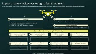
So basically, drones can pinpoint exactly where to spray stuff instead of just blanketing your whole field. GPS and sensors help them spot problem areas - kinda like having a flying smart sprinkler, honestly. You'll save a bunch on chemicals since you're not wasting them on healthy spots. Way faster than driving equipment around too, especially in muddy areas where you can't even get through. I'd probably start by mapping everything first to see which sections actually need the targeted treatment. The precision thing is pretty game-changing for not over-spraying.
Honestly, the money hits first - equipment costs way more than you'd expect, and maintenance keeps bleeding cash. FAA paperwork is a nightmare if you're doing commercial stuff. Weather screws you over constantly too, like when it's windy and you actually need the data. Learning to fly these things properly? That takes forever. The data interpretation part isn't intuitive either - definitely not like using your phone. My buddy started with just mapping his property before expanding to client work. Smart move because trying to do everything at once usually backfires.
Honestly, drones are a game changer for spotting problems early. Those multispectral cameras can see plant stress way before your eyes can - nutrient issues, pests, irrigation problems, all of it. Walking fields only tells you so much, and satellite images? Forget it, too delayed. With a drone you're catching issues while they're still fixable instead of expensive disasters. The cool part is targeting just the problem spots rather than spraying entire fields. Saves money and it's better for the environment too. I'd say fly weekly during growing season if you can swing it.
You'll need to get your Part 107 certificate from the FAA first - it's basically a test on airspace rules and how to fly legally. The hands-on stuff is where it gets interesting though. Flight planning, data collection, reading aerial images of your crops. That image analysis part honestly stumps most people at first, but you kinda need it to catch problems early. Check with your local extension office - they usually know which training programs are decent in your area. A lot of drone companies do ag-specific courses too. My buddy went through one last year and said it was way more helpful than just YouTubing everything.
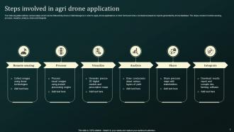
Check if your farm software already works with drone companies first - most do now. Climate FieldView, Granular, AgLeader all sync with drones pretty easily. Your drone shoots NDVI maps and crop health data, then dumps it right into whatever platform you're using. Some even sync automatically after flights which is honestly kind of amazing. If yours doesn't play nice with drones, you might need something like FarmLogs to bridge the gap. But seriously, start by seeing what drone partnerships your current system supports - you'd be surprised how many already exist.
-
Great quality product.
-
Professionally designed slides with color coordinated themes and icons. Perfect for enhancing the style of the presentations.