


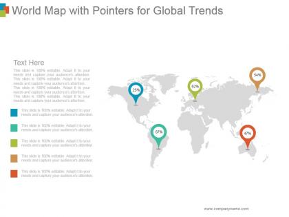
World map with pointers for global trends





Try Before you Buy Download Free Sample Product
 Impress Your
 Audience
 100%
100% Editable
 Save Hours
 of Time


Avoid getting hackneyed with our World Map With Pointers For Global Trends. They keep generating fresh enthusiasm.
People who downloaded this PowerPoint presentation also viewed the following :
World map with pointers for global trends with all 5 slides:
Our incomparable World Map With Pointers For Global Trends provide you with unbridled possibilities to make a powerful impact with your presentation. We have a mind blowing collection of graphics diagrams and slideshows in every category created especially for you by our professional team.
FAQs for World map with pointers
Key indicators for analyzing global trends on maps include economic metrics, demographic shifts, technological adoption rates, environmental data, and social development indices. These indicators enable organizations to visualize patterns across regions, identify emerging markets, and assess competitive landscapes, with many multinational corporations finding that geographic trend analysis streamlines strategic planning and enhances resource allocation decisions.
Cultural, economic, and environmental factors shape global trend patterns by influencing consumer preferences, market accessibility, and regulatory frameworks across different regions. Economic prosperity drives technology adoption in developed markets, while cultural values affect social media usage patterns, and environmental concerns increasingly steer sustainability trends, with many multinational companies finding that successful global strategies require adapting to these interconnected regional variations.
Businesses leverage global trends maps for strategic planning by identifying emerging market opportunities, anticipating consumer behavior shifts, assessing competitive landscapes, and evaluating regulatory changes across regions. These strategic tools enable organizations to allocate resources more effectively, time market entries strategically, and develop products aligned with regional preferences, ultimately delivering competitive advantage and sustainable growth in an increasingly interconnected marketplace.
Technological advancements revolutionize global trends maps by enabling real-time data collection, advanced analytics, interactive visualizations, and predictive modeling capabilities. Through AI-powered analysis and cloud-based platforms, organizations can process vast datasets from social media, market research, and economic indicators, ultimately delivering dynamic, actionable insights that enhance strategic planning and competitive positioning across industries.
Social media platforms serve as real-time data sources for global trends mapping, providing instant insights into public sentiment, viral content, emerging topics, and geographical movement patterns. These platforms enable businesses and researchers to visualize trending hashtags, monitor brand mentions, and track cultural shifts across different regions, ultimately delivering competitive intelligence and market awareness that traditional research methods cannot match in speed or scope.
Global trends maps aid disaster response and risk management by identifying vulnerability patterns, tracking emerging threats, and enabling predictive resource allocation across regions. These visualization tools streamline emergency planning, enhance cross-border coordination, and optimize supply chain logistics, with organizations like FEMA and WHO finding that predictive mapping delivers faster response times, reduced casualties, and more effective resource distribution during critical events.
The most common visualization techniques for representing global trends include heat maps, choropleth maps, bubble charts, flow diagrams, and interactive dashboards with time-series data. These methods enhance understanding by displaying complex patterns, regional variations, and temporal changes across countries, with many organizations finding that combining multiple visualization approaches delivers clearer insights and more compelling presentations.
Demographic changes significantly reshape global trend interpretation by altering consumer behaviors, workforce compositions, market demands, and economic priorities across regions. As populations age in developed nations while emerging markets experience youth booms, businesses must recalibrate their trend analysis, with many multinational companies finding that demographic-adjusted forecasting delivers more accurate market predictions and strategic advantages.
Global trends maps face limitations including data lag affecting real-time accuracy, oversimplification of complex interconnected factors, regional bias toward well-documented markets, and difficulty capturing sudden disruptions or black swan events. While these tools streamline strategic planning by visualizing patterns across industries like healthcare and technology, organizations increasingly combine them with real-time analytics and scenario planning to enhance forecasting precision and competitive advantage.
Educators can utilize global trends maps to enhance geography lessons, demonstrate economic patterns, explore cultural exchanges, analyze migration flows, and illustrate climate change impacts across regions. These interactive tools enable students to visualize complex global relationships, compare regional developments, and understand interconnected world systems, while fostering critical thinking skills and international awareness in an increasingly interconnected educational landscape.
Government policies reflect global trends through regulatory responses to emerging challenges like climate change, digital transformation, and economic shifts, creating interconnected patterns across nations. These can be mapped using comparative policy analysis frameworks, regulatory timeline visualizations, and geopolitical impact matrices that track policy adoption rates, implementation outcomes, and cross-border influences, ultimately enabling organizations to anticipate regulatory changes and strategic opportunities.
Methodologies for maintaining trends map accuracy include continuous data monitoring, periodic stakeholder surveys, expert panel reviews, automated data feeds, and systematic validation processes. These approaches work by cross-referencing multiple sources, incorporating real-time market intelligence, and establishing regular review cycles, with many organizations finding that combining quantitative analytics with qualitative insights delivers the most reliable and actionable trend intelligence.
Geopolitical dynamics significantly reshape global trend trajectories by influencing trade routes, resource accessibility, regulatory frameworks, and cross-border collaborations as depicted on trend maps. These shifts create new economic corridors, alter supply chain patterns, and redirect investment flows, with many multinational corporations finding that geopolitical stability increasingly determines market expansion strategies and competitive positioning.
Effective tools for creating interactive global trends maps include Tableau, Power BI, ArcGIS Online, D3.js, and Google Data Studio. These platforms streamline data visualization by enabling real-time updates, customizable overlays, and dynamic filtering capabilities, with many organizations finding that interactive mapping enhances strategic decision-making and delivers deeper insights into global market patterns.
Ethical considerations include data accuracy verification, cultural sensitivity in interpretation, avoiding misleading visualizations, protecting privacy in demographic data, and acknowledging inherent biases in data collection methods. Organizations presenting global trends must ensure transparent sourcing, respect cultural contexts when drawing conclusions, and avoid oversimplification of complex regional dynamics, ultimately delivering responsible insights that inform rather than misinform stakeholders.
-
Great designs, Easily Editable.
-
Great designs, Easily Editable.