


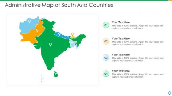
Administrative map of south asia countries




Try Before you Buy Download Free Sample Product
 Impress Your
 Audience
 100%
100% Editable
 Save Hours
 of Time


Our Administrative Map Of South Asia Countries are topically designed to provide an attractive backdrop to any subject. Use them to look like a presentation pro.
People who downloaded this PowerPoint presentation also viewed the following :
Administrative map of south asia countries with all 6 slides:
Use our Administrative Map Of South Asia Countries to effectively help you save your valuable time. They are readymade to fit into any presentation structure.





FAQs for Administrative map of
The administrative map of South Asia features national boundaries encompassing eight countries, state and provincial divisions, major metropolitan centers, and strategic territorial regions including disputed areas. These administrative frameworks streamline governance across diverse populations, facilitate resource allocation and policy implementation, and enable coordinated regional development, with countries like India, Pakistan, and Bangladesh finding that clear territorial demarcations enhance diplomatic relations and cross-border trade efficiency.
Administrative divisions across South Asia vary significantly, with India using states and union territories, Pakistan employing provinces and territories, Bangladesh utilizing divisions and districts, and Sri Lanka organizing through provinces and districts. These structural differences reflect each nation's historical governance patterns, constitutional frameworks, and federal versus unitary systems, with countries like India and Pakistan adopting federal models while others maintain more centralized approaches, ultimately enabling tailored regional administration.
Administrative maps serve as foundational tools for regional planning in South Asia by defining jurisdictional boundaries, resource allocation zones, infrastructure networks, and demographic distributions across countries like India, Pakistan, and Bangladesh. These maps enable governments and development organizations to coordinate cross-border initiatives, optimize transportation corridors, and strategically distribute investments, with many regional bodies finding that clear administrative delineation streamlines economic cooperation and sustainable development projects.
Changes in political boundaries significantly reshape South Asia's administrative maps through territorial redistributions, new state formations, border demarcations, and administrative restructuring following conflicts or negotiations. These modifications require updated governance frameworks, revised jurisdictional authorities, and redrawn electoral constituencies, with countries like India, Pakistan, and Bangladesh continuously adapting their administrative divisions to reflect political realities, ultimately enabling more effective governance and clearer territorial administration.
**INPUT**: What are the historical factors that have shaped the administrative map of South Asia? **OUTPUT**: Historical factors shaping South Asia's administrative map include British colonial administration, partition dynamics, princely state integration, linguistic reorganization movements, and post-independence constitutional frameworks. These influences streamline governance by establishing federal structures, state boundaries, and administrative hierarchies, with many regional governments finding that colonial-era divisions, while presenting integration challenges, ultimately deliver structured administrative systems and enable systematic resource allocation across diverse populations. [Word count: 60 words]
Administrative maps assist disaster management by clearly defining jurisdictional boundaries, emergency response zones, evacuation routes, resource allocation areas, and coordination points between local, regional, and national authorities. These detailed territorial frameworks enable faster emergency response coordination across countries like Bangladesh, India, and Pakistan, streamline cross-border disaster relief efforts, and ultimately deliver more effective resource deployment and coordinated humanitarian assistance during cyclones, floods, and earthquakes.
Administrative units in South Asian countries create multi-tiered governance systems that enable localized decision-making, resource distribution, and policy implementation across diverse populations. These hierarchical structures, from provinces in Pakistan to states in India and districts throughout the region, streamline administrative efficiency by delegating authority closer to citizens, enhancing service delivery, and facilitating targeted development programs, ultimately delivering more responsive governance and improved public administration.
South Asian countries face significant challenges including rapid urbanization, frequent border disputes, limited technological infrastructure, inadequate funding for surveying operations, and complex bureaucratic processes across multiple administrative levels. These obstacles often result in outdated boundary demarcations and inconsistent territorial records, with many governments finding that investing in modern GIS technologies and streamlined inter-departmental coordination ultimately delivers more accurate governance and improved public service delivery.
Technological advancements enhance administrative mapping accuracy through GPS systems, satellite imagery, GIS software, drone surveying, and machine learning algorithms. These technologies streamline boundary demarcation, population tracking, and resource allocation across diverse terrains, with countries like India and Bangladesh finding that digital mapping delivers improved governance efficiency, reduced territorial disputes, and enhanced urban planning capabilities.
Cross-border administrative discrepancies in South Asia create challenges in trade facilitation, resource management, immigration processing, and regional cooperation initiatives. These inconsistencies impact businesses operating across borders, with sectors like manufacturing, logistics, and financial services finding that streamlined administrative harmonization enables faster transactions, reduces compliance costs, and ultimately delivers enhanced regional economic integration.
Demographic factors significantly influence South Asian administrative divisions through population density considerations, ethnic and linguistic community distributions, religious concentrations, and urban-rural population balances. Countries like India and Pakistan have restructured states and provinces to better serve diverse linguistic groups, manage metropolitan growth, and ensure equitable resource allocation, ultimately delivering more targeted governance and enhanced public service delivery across varied demographic landscapes.
International organizations like the United Nations, World Bank, and Asian Development Bank facilitate administrative mapping in South Asia by providing technical expertise, standardization frameworks, and funding for cartographic projects. These organizations streamline cross-border coordination, enhance data sharing protocols, and support regional mapping initiatives, with many South Asian governments finding that collaborative approaches ultimately deliver improved administrative transparency and better resource allocation for development planning.
Local languages and cultural contexts significantly influence administrative map representation through multilingual labeling, culturally appropriate symbols, and region-specific administrative boundaries that reflect ethnic or linguistic divisions. Many South Asian countries incorporate vernacular scripts alongside English, with states like India using Hindi, regional languages, and English on official maps, while countries like Sri Lanka balance Sinhala and Tamil representations, ultimately delivering more inclusive governance and enhanced local accessibility.
**INPUT**: What are some examples of conflicts arising from administrative boundaries in South Asia? **OUTPUT**: Administrative boundary conflicts in South Asia include the Kashmir dispute between India and Pakistan, territorial tensions along the India-China border, water rights disagreements between Indian states, and ethnic divisions in Sri Lanka's provincial boundaries. These boundary challenges present both diplomatic complexities and opportunities for enhanced regional cooperation, with many international organizations finding that collaborative frameworks, shared resource management, and cross-border economic partnerships ultimately deliver stronger regional stability and economic integration. **Word count: 60 words**
Educational institutions can utilize administrative maps by incorporating interactive digital displays, comparative boundary studies, population density analysis, and historical border evolution lessons into their geography curricula. Through these visual tools, schools and universities enhance student understanding of regional political structures, demographic patterns, and geopolitical relationships across South Asian nations, ultimately delivering more engaging and comprehensive geographic education.
-
Editable templates with innovative design and color combination.
-
Graphics are very appealing to eyes.
-
Designs have enough space to add content.
-
Editable templates with innovative design and color combination.
-
Topic best represented with attractive design.
-
Excellent work done on template design and graphics.
-
Excellent template with unique design.
-
Top Quality presentations that are easily editable.