


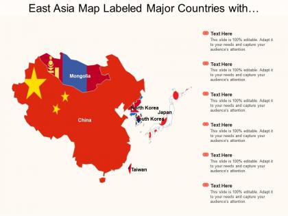
East asia map labeled major countries with mongolia and taiwan




Try Before you Buy Download Free Sample Product
 Impress Your
 Audience
 100%
100% Editable
 Save Hours
 of Time


Our East Asia Map Labeled Major Countries With Mongolia And Taiwan ensure you don't dwell in dreamland. Convert aspirations into facts.
People who downloaded this PowerPoint presentation also viewed the following :
East asia map labeled major countries with mongolia and taiwan with all 5 slides:
Our East Asia Map Labeled Major Countries With Mongolia And Taiwan make you feel glad. Each one is an absolute delight.




FAQs for East asia map labeled major countries with
A labeled East Asia map should highlight major countries like China, Japan, South Korea, North Korea, Mongolia, and Taiwan, along with capital cities, significant mountain ranges, major rivers, and key bodies of water. These geographic elements enable comprehensive regional understanding by showcasing political boundaries, economic centers, and natural resources, with many educational institutions and businesses finding that detailed regional maps enhance strategic planning and cultural awareness in an increasingly interconnected global marketplace.
East Asia's diverse geography significantly shapes regional cultures through mountainous barriers that preserve distinct languages and traditions, extensive coastlines that foster maritime trade cultures, and river valleys that support dense agricultural societies. These geographical features create cultural variations from Japan's island isolation promoting unique customs, to China's vast plains enabling unified civilizations, and Korea's peninsular position facilitating cultural exchange, ultimately delivering rich diversity within shared regional influences.
Major political boundaries in an East Asia map include China, Japan, South Korea, North Korea, Mongolia, and Taiwan, along with their respective territorial waters and disputed regions. These boundaries illustrate complex geopolitical relationships, trade corridors, and strategic partnerships that significantly impact global commerce, with many international businesses finding that understanding regional political dynamics enhances market entry strategies and operational planning.
**INPUT**: How do physical features like mountains and rivers impact East Asia's climate? **OUTPUT**: Physical features significantly shape East Asia's climate through monsoon patterns, temperature regulation, and precipitation distribution across diverse topographical zones. Mountain ranges like the Himalayas block cold Arctic air while channeling warm, moist winds, and major river systems create microclimates that enhance agricultural productivity, ultimately delivering varied climate zones that support diverse economies from manufacturing to agriculture. [Word count: 58 words]
Major economic hubs on an East Asia map include Tokyo, Shanghai, Hong Kong, Seoul, Singapore, Beijing, and Taipei, representing powerhouses of finance, technology, and manufacturing. These metropolitan centers drive regional growth through strategic positioning, advanced infrastructure, and innovation ecosystems, with many multinational corporations finding them essential for accessing Asia-Pacific markets and establishing competitive advantage.
Historical events have fundamentally shaped East Asia's modern boundaries through colonization, wars, territorial partitions, and independence movements that redefined national borders across China, Japan, Korea, and Southeast Asia. Major conflicts like World War II, the Chinese Civil War, and Korean War created today's political divisions, with many nations finding that understanding these historical boundaries enhances diplomatic relations and regional trade strategies.
Islands in East Asia serve as strategic military bases, territorial boundary markers, resource control points, and trade route chokepoints. These geographic features significantly influence regional power dynamics, with nations like Japan, Taiwan, and the Philippines leveraging their island positions for defense advantages, economic zones, and diplomatic influence, ultimately shaping military alliances and trade relationships across the region.
Labeled maps enhance East Asian educational settings by providing visual context for historical events, economic patterns, cultural regions, political boundaries, and geographic features. These educational tools streamline complex regional understanding through clear identification of countries, capitals, and major cities, while enabling students to connect theoretical knowledge with spatial reality, ultimately delivering improved comprehension and retention in geography, history, and international studies curricula.
Common misconceptions about East Asia's geography include assuming all countries share similar climates, underestimating the region's vast size and diversity, believing it's primarily mountainous, and thinking major cities are inland rather than coastal. These oversimplifications overlook East Asia's incredible geographic variety, from tropical Southeast Asian archipelagos to Siberian tundra, ultimately missing strategic opportunities for businesses expanding into these diverse, economically dynamic markets.
Transportation networks on labeled East Asian maps display major highways, railway systems, shipping routes, and aviation corridors connecting key economic centers across China, Japan, South Korea, and regional hubs. These comprehensive networks illustrate critical trade pathways, high-speed rail connections, and maritime shipping lanes, with many logistics companies and regional planners finding that visualized transportation data streamlines route optimization and enhances cross-border commerce efficiency.
East Asia faces significant environmental challenges including air pollution from industrial centers, deforestation across mountainous regions, water contamination in major river systems, coastal erosion, and urban heat island effects. These issues particularly impact densely populated areas like China's manufacturing belt and Japan's metropolitan zones, where rapid industrialization and urbanization create complex environmental pressures requiring strategic regional cooperation and sustainable development approaches.
**Tokyo, Shanghai, Beijing, Seoul, Hong Kong, and Singapore** represent crucial cities for understanding East Asia's urban development, each demonstrating distinct approaches to modernization, infrastructure planning, and economic integration. These metropolitan centers showcase different models of sustainable growth, technological innovation, and cultural preservation, with urban planners and policymakers increasingly studying their strategies to address challenges like population density, environmental sustainability, and smart city implementation across rapidly developing regions.
East Asia's diverse topography, including mountain ranges, river valleys, coastal plains, and varied elevations, creates numerous microclimates and ecological niches that support exceptional biodiversity. This geographic complexity enables distinct ecosystems from tropical rainforests to alpine meadows, with isolated mountain regions fostering endemic species development, while river systems and coastal areas provide migration corridors, ultimately delivering rich biological diversity across the region.
**INPUT**: What cultural landmarks should be labeled on a map of East Asia? **OUTPUT**: Essential cultural landmarks include the Great Wall of China, Angkor Wat, Mount Fuji, Gyeongbokgung Palace, and the Forbidden City, representing centuries of architectural and spiritual heritage. These sites enhance educational presentations by providing cultural context for business discussions, tourism planning, and international relations, with many organizations finding that visual cultural references strengthen cross-cultural understanding and strategic partnerships. [Word count: 60 words]
A labeled East Asia map for tourism emphasizes major cities, attractions, transportation routes, and cultural landmarks, while educational maps focus on capitals, political boundaries, physical features, and demographic data. Tourism maps streamline information for travelers by highlighting hotels, airports, and popular destinations across countries like Japan, China, and South Korea, whereas educational versions deliver comprehensive geographical and political details, ultimately serving distinct learning objectives with specialized information relevant to each audience's specific needs.
-
Best Representation of topics, really appreciable.
-
Unique design & color.