


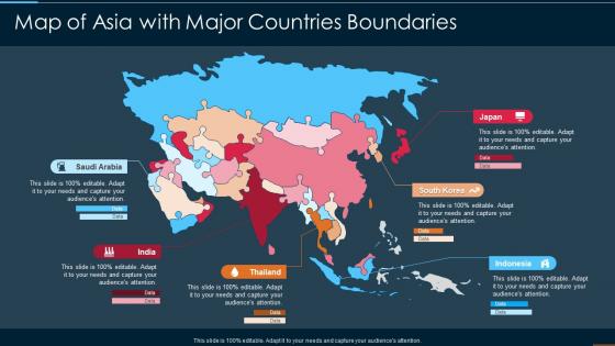
Map Of Asia With Major Countries Boundaries




Try Before you Buy Download Free Sample Product
 Impress Your
 Audience
 100%
100% Editable
 Save Hours
 of Time


Our Map Of Asia With Major Countries Boundaries are topically designed to provide an attractive backdrop to any subject. Use them to look like a presentation pro.
People who downloaded this PowerPoint presentation also viewed the following :
Map Of Asia With Major Countries Boundaries with all 6 slides:
Use our Map Of Asia With Major Countries Boundaries to effectively help you save your valuable time. They are readymade to fit into any presentation structure.





FAQs for Map Of Asia With
Common map projections for representing Asia include the Miller Cylindrical, Lambert Azimuthal Equal-Area, Albers Equal-Area Conic, Mercator, and Robinson projections. These projections address Asia's vast east-west expanse and diverse latitudinal range by minimizing distortion, preserving area relationships, and maintaining navigational accuracy, with many cartographers finding that combining multiple projections delivers optimal representation for different analytical and educational purposes.
Cultural and political boundaries significantly shape Asian cartography by determining territorial representations, border demarcations, naming conventions, and regional emphasize. Through governmental mapping agencies, countries like China, India, and Japan create maps reflecting their political perspectives on disputed territories, cultural heritage sites, and strategic waterways, while balancing diplomatic sensitivities with national interests, ultimately delivering varied cartographic interpretations across the region.
Geographical features fundamentally define Asia's map through massive mountain ranges like the Himalayas and Urals, extensive river systems including the Ganges and Yangtze, vast deserts such as the Gobi, and strategic coastlines along multiple seas. These natural boundaries create distinct regional clusters, influence population distribution and economic corridors, while ultimately shaping trade routes, cultural exchanges, and geopolitical relationships across the continent.
GIS and satellite imagery have revolutionized Asian map-making by enabling real-time data collection, precise geographic modeling, and dynamic updating capabilities that traditional methods couldn't achieve. Through these technologies, governments and organizations across China, India, and Southeast Asia streamline urban planning, disaster management, and infrastructure development, while delivering enhanced accuracy and significantly faster mapping services for increasingly complex regional challenges.
Key historical events reshaping Asia's map include colonial partitions, post-WWII independence movements, the 1947 India-Pakistan partition, China's 1949 revolution, and the Korean War division. These transformations fundamentally altered national boundaries through decolonization, ideological conflicts, and religious separations, with countries like Indonesia, Malaysia, and Bangladesh ultimately gaining independence and establishing modern geopolitical frameworks that define contemporary Asian commerce and diplomacy.
Asian countries approach territorial disputes through varied cartographic strategies, including disputed boundary markings, contested territory shading, territorial claim annotations, and sovereignty assertions on official maps. These mapping approaches enable nations to reinforce legal positions, communicate political stances, and maintain diplomatic flexibility, with many governments finding that strategic cartographic representation supports broader geopolitical objectives while facilitating international negotiations.
Cartographic accuracy significantly influences Asian trade efficiency by enabling optimal route planning, reducing transportation costs, and facilitating cross-border commerce through standardized geographic references. Precise mapping enhances supply chain logistics across manufacturing hubs like China and Southeast Asia, while supporting infrastructure development and port optimization, ultimately delivering competitive advantages and streamlined regional economic integration for businesses.
Maps serve as powerful educational tools for environmental issues by visualizing deforestation patterns, pollution levels, climate change impacts, water scarcity zones, and biodiversity hotspots across Asia's diverse regions. Through interactive digital mapping and satellite imagery, educators can demonstrate real-time environmental challenges like air quality in major cities, coastal erosion effects, and habitat loss, ultimately enabling students to understand complex ecological relationships and develop informed perspectives on sustainability solutions.
Cartographers mapping remote Asian areas face terrain accessibility challenges, limited ground verification data, rapidly changing political boundaries, and cultural sensitivity requirements when documenting indigenous territories. These obstacles are amplified by extreme weather conditions in regions like the Himalayas and Siberian wilderness, while satellite technology increasingly helps overcome traditional surveying limitations, ultimately enabling more accurate regional planning and resource management.
Thematic maps focus on specific socio-economic variables like GDP distribution, population density, literacy rates, or trade patterns across Asian countries, while general maps display basic geographical features, borders, and locations. These specialized visualizations enable policymakers, businesses, and researchers to identify economic corridors, development disparities, and investment opportunities throughout Asia's diverse markets, ultimately delivering strategic insights for regional planning.
Ancient maps of Asia reveal trade routes, political boundaries, cultural exchanges, and settlement patterns that shaped civilizations across the continent. These historical documents enable researchers, educators, and institutions to understand how empires like the Silk Road networks, Ming Dynasty, and Mongol territories influenced economic development, technological transfer, and diplomatic relationships, ultimately delivering insights into Asia's foundational role in global commerce and cultural evolution.
Asia's perception through maps has evolved from medieval European depictions showing mythical lands and sparse coastal knowledge to detailed contemporary representations reflecting economic powerhouses and technological hubs. Modern cartographic approaches increasingly emphasize Asia's manufacturing centers, trade routes, and innovation corridors, with many businesses finding that updated regional maps better support strategic expansion and market analysis.
Common misconceptions include viewing Asia as culturally homogeneous, underestimating its economic diversity, and oversimplifying its geographic complexity across 48+ countries. Accurate mapping reveals distinct regional clusters, from Southeast Asia's maritime economies to Central Asia's resource-rich landlocked nations, enabling businesses to develop targeted strategies rather than broad-brush approaches, ultimately delivering more effective market entry and expansion outcomes.
Language and cultural variations significantly influence Asian map labeling through transliteration choices, disputed territorial names, and culturally-specific geographic terminology that varies between nations. While Western cartographers often use standardized English transliterations, regional maps reflect local naming conventions, with many institutions finding that culturally-sensitive labeling enhances accuracy and diplomatic relations in this linguistically diverse continent.
Future mapping trends affecting Asia's visual representation include augmented reality overlays, real-time satellite integration, AI-powered demographic visualization, interactive 3D modeling, and dynamic economic data mapping. These technologies enhance geographic understanding by delivering live infrastructure updates, population movement tracking, and economic trend visualization, with many educational institutions and businesses finding that interactive mapping significantly improves strategic planning and regional analysis capabilities.
-
“I've always gotten excellent slides from them and the customer service is up to the mark.”
-
Great quality product.