


Revolutionizing Agriculture Exploring Drone Technology In Farming Ppt Slide Agri CD





Try Before you Buy Download Free Sample Product
 Impress Your
 Audience
 100%
100% Editable
 Save Hours
 of Time


This presentation, titled The Revolutionizing Agriculture Exploring Drone Technology in Farming, goes into deep detail about the trends of drones in the contemporary agricultural era. Through this presentation, an exploration of how drone technology enables precision agriculture and crop health and maximizes resource use will be cited. By the end of it, you will gain insights into the various types of agriculture drones available, their functions, and how they promote sustainable farming practices. It mainly discusses implementing concrete applications and real-world examples to highlight important benefits, such as efficiency, costs, and yields. Futher, it covers the perspectives on regulation and technological constraints, offering a comprehensive view of the present reality. This presentation is perfect for farmers, agricultural professionals, and technology enthusiasts who want to know how drones will revolutionize farming techniques. Engaging visuals and data-driven insights, a blend of expertise for a comprehensive, informative experience underlining the potentialities of drone technology within the agriculture sector. Get access now.
People who downloaded this PowerPoint presentation also viewed the following :
Content of this Powerpoint Presentation
Slide 1: This slide introduces Revolutionizing Agriculture: Exploring Drone Technology in Farming. State your company name and begin.
Slide 2: This is an Agenda slide. State your agendas here.
Slide 3: This slide shows Table of Content for the presentation.
Slide 4: This slide highlights the topics to be covered next.
Slide 5: This slide highlights various issues of conventional agriculture methodologies.
Slide 6: This slide covers various emerging technologies that can be implemented to improve farming results.
Slide 7: This is another slide highlighting the topics to be covered next.
Slide 8: This slide represents a graphical representation of the worldwide drone market for farming.
Slide 9: This slide covers various emerging drone market trends, such as the rise of AI and machine learning, increased integration of multispectral sensors, etc.
Slide 10: This slide highlights the topics to be covered next.
Slide 11: This slide briefly overviews unmanned aerial vehicles called drones used in agriculture operations.
Slide 12: This slide highlights the advantages of drone farming. These include improved efficiency, enhanced crop yields, reduced costs, and improved accuracy.
Slide 13: This slide covers major sensor technologies implemented in drones for farming. It includes technologies such as RGB Cameras, Multispectral Cameras, Thermal Cameras, etc.
Slide 14: This slide presents various strategies for adopting drones for farming. It includes information related to manufacturer’s guidelines, pre-flight checks, flight planning, etc.
Slide 15: This is another slide highlighting the topics to be covered next.
Slide 16: This slide shows a brief overview of fixed-wing drones for farming. It includes applications such as gathering aerial imagery, field mapping, crop monitoring, etc.
Slide 17: This slide covers the major benefits and disadvantages of implementing fixed-wing drones.
Slide 18: This slide provides a brief overview of farming using single-rotor drones.
Slide 19: This slide showcases the major benefits and disadvantages of implementing single-rotor drones.
Slide 20: This slide highlights a brief overview of farming using multi-rotor drones. It includes information related to irrigation management, livestock monitoring, and pesticide and fertilizer application.
Slide 21: This slide covers the major benefits and disadvantages of implementing multi-rotor drones.
Slide 22: This slide outlines a brief overview of farming using hybrid drones. It includes applications such as pesticide spraying, high-resolution mapping, plant counting, and yield estimation.
Slide 23: This slide provides the major benefits and disadvantages of implementing hybrid drones.
Slide 24: This slide highlights the topics to be covered next.
Slide 25: This slide covers key use cases of drone farming such as drone seeding, soil monitoring, drone mapping, crop monitoring, drone seeding, livestock management, and irrigation management.
Slide 26: This slide briefly overviews drone seeding for precise and efficient dispersal over large areas.
Slide 27: This slide showcases various steps of implementing drones for seed plantations in agriculture.
Slide 28: This is another slide highlighting the topics to be covered next.
Slide 29: This slide briefly overviews drone technology applications for soil health assessment.
Slide 30: This slide covers various steps of soil moisture assessment, such as drone deployment, data collection, data analysis, decision-making, and action.
Slide 31: This slide highlights the topics to be covered next.
Slide 32: This slide briefly overviews drone technology applications for field monitoring.
Slide 33: This slide provides various use cases of drone technology for farming such as crop health monitoring, soil and irrigation management, land use planning and environmental impact, etc..
Slide 34: This slide explains key use cases of drone technology in crop monitoring.
Slide 35: This slide covers case studies of adopting drones for crop inspection.
Slide 36: This slide highlights various considerations for agricultural drome technology issues such as privacy, technical matters, accessibility, and adoption.
Slide 37: This is another slide highlighting the topics to be covered next.
Slide 38: This slide briefly overviews drone technology applications for irrigation system management.
Slide 39: This slide covers key problems faced by farmers due to conventional irrigation methods.
Slide 40: This slide mentions key cases of agricultural drones being used for irrigation management.
Slide 41: This slide highlights the topics to be covered next.
Slide 42: This slide briefly overviews drone technology applications for livestock welfare.
Slide 43: This slide covers key cases of agricultural drones being used in animal management.
Slide 44: This is another slide highlighting the topics to be covered next.
Slide 45: This slide showcases major cases of the use of drone technology for precision agriculture.
Slide 46: This slide highlights the topics to be covered next.
Slide 47: This slide provides various methods of using drone data for crop decision-making.
Slide 48: This slide outlines the process of implementing drones for agricultural operations.
Slide 49: This slide depicts a checklist for choosing the appropriate drone per farming requirements.
Slide 50: This slide represents a checklist for identifying major considerations of using drones for agriculture operations.
Slide 51: This slide covers drones as a service to improve technology access.
Slide 52: This slide provides approximate cost ranges for various agriculture drone services.
Slide 53: This slide covers key considerations for overcoming drone implementation issues in farming.
Slide 54: This is another slide highlighting the topics to be covered next.
Slide 55: This slide covers the key environmental impact of implementing drone technology for farming.
Slide 56: This slide highlights the topics to be covered next.
Slide 57: This slide showcases success stories of using drones for agriculture.
Slide 58: This is another slide highlighting the topics to be covered next.
Slide 59: This slide covers emerging future trends in agricultural drones.
Slide 60: This slide shows all the icons included in the presentation.
Slide 61: This slide is titled as Additional Slides for moving forward.
Slide 62: This is Our Vision, Mission & Goal slide. Post your Visions, Missions, and Goals here.
Slide 63: This is an Idea Generation slide to state a new idea or highlight information, specifications etc.
Slide 64: This slide shows Post It Notes. Post your important notes here.
Slide 65: This slide contains Puzzle with related icons and text.
Slide 66: This is a Financial slide. Show your finance related stuff here.
Slide 67: This slide shows SWOT describing- Strength, Weakness, Opportunity, and Threat
Slide 68: This slide provides 30 60 90 Days Plan with text boxes.
Slide 69: This slide depicts Venn diagram with text boxes.
Slide 70: This is a Timeline slide. Show data related to time intervals here.
Slide 71: This slide presents Roadmap with additional textboxes.
Slide 72: This is a Thank You slide with address, contact numbers and email address.
Revolutionizing Agriculture Exploring Drone Technology In Farming Ppt Slide Agri CD with all 80 slides:
Use our Revolutionizing Agriculture Exploring Drone Technology In Farming Ppt Slide Agri CD to effectively help you save your valuable time. They are readymade to fit into any presentation structure.
-

Revolutionizing Agriculture Exploring Drone Technology in Farming
-
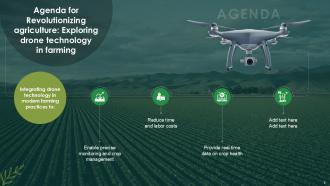
Agenda for Revolutionizing agriculture Exploring drone technology in farming
-
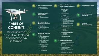
Revolutionizing agriculture Exploring drone technology in farming
-
Table of contents for revolutionizing agriculture Exploring drone technology in farming
-
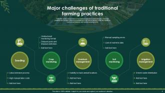
Major challenges of traditional farming practices
-
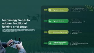
Technology trends to address traditional farming challenges
-
Table of contents for revolutionizing agriculture Exploring drone technology in farming
-
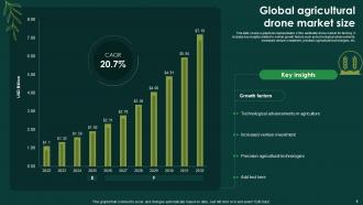
Global agricultural drone market size
-

Agriculture drone market trends and insights
-

Table of contents for revolutionizing agriculture Exploring drone technology in farming
-

Introduction to drone farming for improved agriculture operations
-

Major benefits of implementing drones in agriculture
-

Key sensor technologies used in agricultural drones
-

Best practices for using drones in agriculture
-

Table of contents for revolutionizing agriculture Exploring drone technology in farming
-

Introduction to fixed wing drones in agriculture
-

Pros and cons of using fixed wing drones
-

Introduction to single rotor drones in agriculture
-

Pros and cons of using single rotor drones
-

Introduction to multi rotor drones in agriculture
-

Pros and cons of using multi rotor drones
-

Introduction to hybrid drones in agriculture
-

Pros and cons of using hybrid drones in agriculture
-

Table of contents for revolutionizing agriculture Exploring drone technology in farming
-

Major applications of drones in agriculture sector
-

Introduction to drones seeding in agriculture sector
-

Process of using drone seed plantation in agriculture
-

Table of contents for revolutionizing agriculture Exploring drone technology in farming
-

Introduction to drones for soil monitoring
-

Drone based soil moisture monitoring process
-

Table of contents for revolutionizing agriculture Exploring drone technology in farming
-

Introduction to agricultural drone mapping and crop monitoring
-

Applications of drones for agriculture mapping
-

Major applications of drones in crop inspection
-

Successful implementations of farming drones for crop monitoring
-

Solutions to address concerns in agricultural drone mapping
-

Table of contents for revolutionizing agriculture Exploring drone technology in farming
-

Introduction to agricultural drone for irrigation management
-

Major limitations of traditional irrigation methods
-

Applications of drones for precision and efficiency in irrigation systems
-

Table of contents for revolutionizing agriculture Exploring drone technology in farming
-

Introduction to agricultural drone for livestock management
-

Applications of drone farming in livestock management
-

Table of contents for revolutionizing agriculture Exploring drone technology in farming
-

Agricultural drone applications for precision farming
-

Table of contents for revolutionizing agriculture Exploring drone technology in farming
-

Ways to interpret agricultural drone data for crop decisions
-

Drone implementation steps for farming operations
-

Checklist for selecting right drone for agriculture needs
-

Legal and regulatory considerations checklist for drone operation
-

Drone as a Service DaaS to increase technology accessibility
-

Cost for different agriculture drone services
-

Solutions to address drone adoption challenges in agriculture
-

Table of contents for revolutionizing agriculture Exploring drone technology in farming
-

Environmental impact of using drones in agriculture
-

Table of contents for revolutionizing agriculture Exploring drone technology in farming
-

Implementing agricultural drones for soybean farming
-

Table of contents for revolutionizing agriculture Exploring drone technology in farming
-

Future trends of agriculture drone market
-

Icons slide Revolutionizing agriculture Exploring drone technology in farming
-

Additional slides
-

Our Mission
-

Idea generation
-

Posts it notes
-

Puzzle
-

Financial
-

SWOT analysis
-

30 60 90 Days plan
-

Venn diagram
-

Timeline
-

Roadmap
-

Thanks for watching
-

-

-

-

-

-

-

-

FAQs for Revolutionizing Agriculture Exploring Drone Technology In Farming Ppt
Honestly, drones are pretty much taking over everything these days. Farmers use them to check crops and spray pesticides - way more efficient than doing it manually. Construction sites love them for surveys and tracking how projects are going. You've probably seen those crazy aerial shots in movies? That's all drone work now. Amazon's still testing package delivery (though I'm not sure how well that's going lol). Emergency teams use them for search and rescue too. Oh, and real estate agents are obsessed - every property video has those swooping overhead shots now. Police and border patrol jumped on this tech early. Just make sure you check the rules for your industry first - regulations can be pretty strict.
Drones are honestly a game-changer for farming. Instead of walking fields for hours, you can check everything in minutes. They spot disease and pests early, plus the thermal cameras show you exactly which areas need water or have plant stress. Some even spray pesticides or drop seeds on their own - crazy how advanced they've gotten. The best part? You only treat problem spots instead of the whole field, so you're saving money and using way fewer chemicals. Definitely look up some videos of them in action, it's pretty impressive stuff to watch.
Drones are seriously a lifesaver for disaster response. They can scope out damage from above without risking anyone's safety, which is huge. You'll spot survivors in places rescue teams can't easily reach, plus they're perfect for dropping off medical supplies or radios to people who are stuck. Real-time mapping of floods and tracking wildfire spread? Super helpful for planning evacuations. My cousin works in emergency management and swears by them - the speed factor alone is crazy valuable when people's lives are on the line. Definitely worth getting pilots certified beforehand though.
Honestly, the regulations are a total mess right now. Every country, state, and city has different rules - it's chaos. You'll need FAA registration and Remote Pilot cert for the US, but then some random town can just ban drones entirely. Privacy laws? Good luck figuring those out. Commercial stuff gets way more complicated with logging requirements and insurance headaches. The worst part is lawmakers can't keep up with how fast this tech moves, so rules change constantly. Oh, and definitely check local restrictions before flying anywhere. Maybe join AUVSI or something similar to stay updated on all the changes.
Dude, drones are seriously amazing for environmental stuff. They can cover huge areas without freaking out the animals or messing up ecosystems. Conservation groups use them to count endangered species with thermal cameras - sometimes at night which is pretty wild. You can monitor deforestation, track water quality, spot illegal logging or poaching. Way cheaper than hiring helicopters too, though obviously not as comprehensive as satellites for massive projects. The real-time data beats traditional ground surveys by miles. Honestly, if you're doing any environmental work, you should totally reach out to local conservation orgs about partnering up.
Honestly, solid-state batteries are gonna be the real game changer here. Right now most consumer drones only get like 20-30 minutes of flight time, which is pretty limiting. But with better energy density, we could see that double or even triple. Fast-charging is another big one - nobody wants to sit around for hours waiting to fly again. Companies are also working on smarter battery management that adjusts power usage on the fly. Oh, and definitely keep tabs on lithium-sulfur research too. Once we nail longer flights AND quick charging, that's when drones will actually make sense for serious commercial work instead of just being expensive toys.
Drones are honestly a game-changer for traffic stuff. Way cheaper than helicopters and you get real-time data that's actually useful. Perfect for watching traffic patterns during rush hour - you can spot where things get backed up and adjust signals on the fly. The video quality now is pretty insane too. Construction monitoring is another big win. I'd definitely start with just one messy intersection though, maybe that nightmare spot downtown? Test it there first so you can show your boss actual results. Once they see how well it works, you'll probably get budget for more.
Honestly, drones are perfect for this stuff. Blood, vaccines, insulin - you can get it all delivered in hours instead of waiting weeks. No roads? Doesn't matter. Rwanda's doing this right now and cut some delivery times from hours down to like 15 minutes, which is honestly insane. The cool thing is you totally skip the whole infrastructure nightmare - bridges, landing strips, all that headache stuff. Oh and check out Zipline if you haven't already, they're probably the biggest name doing this. Most regions have pilot programs starting up too, so definitely worth looking into partnerships.
Honestly, it's creepy AF - you're basically putting flying cameras over people who never said "yeah, film me." Big power imbalance too when cops or companies can just watch everyone with zero oversight. People clam up when they know they're being recorded, so say goodbye to normal protests or gatherings. Where's all that footage going anyway? Who sees it, stores it, shares it? The whole Big Brother thing but actually flying around lol. If someone's dead set on using them, at least be upfront about when and why. Communities deserve to know what's hovering over their heads.
Honestly, drones are pretty amazing for public safety stuff. They're way cheaper than helicopters and you can get them up fast for search and rescue or missing person cases. Crime scene documentation becomes so much easier with that overhead view. Your officers stay safer too since they don't have to get into sketchy situations right away. Traffic accidents, crowd control at big events, even tactical ops - the applications are endless. Oh, and disaster response is huge. I'd figure out what your department struggles with most and start there. That bird's-eye perspective changes everything once you have it.
Dude, drone payload stuff is getting crazy good lately. Battery tech is where the real magic happens - lithium-sulfur and solid-state are crushing the old lithium-ion ones for power-to-weight. They're also totally redesigning rotors with variable pitch props. Way more efficient motors too. Oh, and carbon fiber is finally getting cheaper, which is awesome because that stuff used to cost a fortune. The aerodynamics improvements are honestly kind of boring to explain but they work. If you're shopping around, I'd focus on the battery systems first - that's gonna make the biggest difference for what you can actually carry.
Honestly, drones are perfect for this kind of stuff. You can hit dangerous spots, crazy remote areas, or places that'd cost a fortune to access otherwise. Wildlife monitoring without freaking out the animals, mapping terrain, air samples at different heights - the works. Glacier tracking is pretty cool too. They're fast and you get way better coverage than trudging around on foot. Plus the data's consistent since you can repeat the exact same flight path. Oh, and apparently people use them near volcanoes now? Seems sketchy but whatever. If your research needs spatial data, definitely look into it. You'll probably wonder why you didn't start with drones.
Dude, drones are totally changing the logistics game right now. Amazon and UPS are already using them for deliveries in remote spots where trucks just can't get to easily. Warehouses have them flying around doing inventory counts - looks like something out of a sci-fi movie honestly. The best part? They skip all the traffic mess and reach crazy hard-to-access places super fast. You'll get way better visibility on your supply chain too since they can track shipments and check infrastructure. Oh, and regulatory stuff is loosening up quickly, so if you're thinking about it, definitely start testing some pilot programs soon.
Honestly, there's some cool stuff happening right now. AI is making drones way smarter for navigation and decisions. Battery tech is finally catching up too - we might actually get decent flight times soon. Package delivery still feels like it's been "coming soon" for ages, but agricultural monitoring and infrastructure inspection are really taking off. Emergency response is huge too. Oh, and regulations are getting less annoying for commercial use. But seriously, watch the companies doing swarm tech - that's where the crazy innovation is. Multiple drones working together? That's the future right there.
So AI basically makes drones way smarter - they can avoid obstacles on their own, plan flight paths, and recognize stuff like people or cars without you babysitting every move. The computer vision tech is honestly insane now. Your drone can handle weather changes, work with other drones, and even predict when it needs maintenance. I'd definitely go for models with AI flight controllers if you're using them for work - saves so much time and you won't want to throw the thing across the room when it gets stuck on a tree branch or whatever.
-
Easily Understandable slides.
-
Amazing slides! Unique, attractive, and easy to understand.