


Universe theme with satellite image of earth




Try Before you Buy Download Free Sample Product
 Impress Your
 Audience
 100%
100% Editable
 Save Hours
 of Time


Discover a new you with our Universe Theme With Satellite Image Of Earth. They will help you hone your talents.
People who downloaded this PowerPoint presentation also viewed the following :
Content of this Powerpoint Presentation
Description:
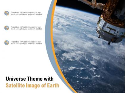
This image features a presentation slide with a Universe theme encapsulating a striking satellite image of Earth. The backdrop showcases our planet viewed from space, highlighting the curvature of the Earth against the vastness of space, with a part of a satellite visible in the frame. This creates a visually engaging context for the slide's content.
This phrase communicates the flexibility of the template, emphasizing its customizable nature which allows presenters to tailor the content according to their specific requirements and to ensure that the presentation grabs the attention of the audience effectively.
Use Cases:
Now, let's explore seven specific industries where such a slide can be applied, along with their potential uses, presenters, and respective audiences:
1. Aerospace:
Use: Presenting advancements in satellite technology
Presenter: Aerospace engineer
Audience: Industry stakeholders
2. Education:
Use: Teaching students about Earth and space studies
Presenter: Science educator
Audience: Students
3. Environmental Science:
Use: Discussing climate change and Earth observation data
Presenter: Environmental scientist
Audience: Policymakers or environmentalists
4. Space Tourism:
Use: Marketing space travel experiences
Presenter: Marketing manager
Audience: Potential space tourists
5. Astrophysics:
Use: Explaining research findings on Earth's position in the universe
Presenter: Astrophysicist
Audience: Academic peers or students
6. Government Agencies:
Use: Policy presentation on space regulation and exploration
Presenter: Government official
Audience: Lawmakers and the general public
7. Technology Conferences:
Use: Unveiling new software for satellite imaging processing
Presenter: Tech innovator
Audience: Industry experts and enthusiasts
Universe theme with satellite image of earth with all 2 slides:
Our Universe Theme With Satellite Image Of Earth do not discriminate. They give equal weightage to all your ideas.

FAQs for Universe theme with satellite
From space, Earth's landmasses appear as varied brown, green, and white patches contrasting dramatically with the deep blue oceans, while cloud formations create swirling white patterns across both. These visual distinctions enable satellite imaging technologies to enhance agricultural monitoring, climate research, and environmental management across industries, with many organizations finding that space-based observation delivers unprecedented insights for strategic decision-making and resource optimization.
Satellite images contribute to climate understanding by monitoring temperature patterns, tracking ice sheet movements, measuring sea level changes, documenting deforestation rates, and analyzing atmospheric composition over decades. Through comprehensive Earth observation systems, scientists can quantify glacier retreat, ocean warming, and extreme weather patterns, while organizations increasingly leverage this data for environmental planning, resource management, and strategic climate adaptation initiatives.
Satellite imaging technologies include optical sensors, synthetic aperture radar, multispectral scanners, hyperspectral instruments, and thermal infrared cameras. These systems enhance environmental monitoring, disaster response, and urban planning by delivering detailed surface analysis, weather tracking, and agricultural assessment, with many aerospace organizations finding that advanced imaging capabilities ultimately provide strategic advantages for research institutions and commercial enterprises.
Astronauts consistently describe seeing Earth from orbit as profoundly transformative, evoking feelings of awe, unity, and protective responsibility toward our planet's fragility. This "overview effect" experience enhances perspective on global interconnectedness, environmental stewardship, and humanity's shared destiny, with many finding that the borderless, beautiful view fundamentally shifts their worldview and priorities.
Earth observation satellites play crucial roles in disaster management by providing real-time monitoring, early warning systems, damage assessment capabilities, and coordination support for emergency response teams. These technologies enhance preparedness by tracking weather patterns, identifying vulnerable areas, and enabling rapid deployment of resources, with agencies like FEMA and international relief organizations finding that satellite data significantly reduces response times and improves rescue coordination efforts.
Space exploration has fundamentally transformed our understanding of Earth by revealing its interconnected systems, fragile atmosphere, and unified global ecosystem through unprecedented orbital photography and satellite imagery. These advances enable scientists, policymakers, and organizations to monitor climate patterns, track environmental changes, and manage resources more strategically, ultimately delivering enhanced environmental stewardship and data-driven sustainability initiatives.
The most common artificial structures visible from space include major cities with dense lighting, extensive highway networks, large-scale agricultural patterns, massive mining operations, and significant industrial complexes. These structures reveal humanity's urbanization trends, transportation infrastructure development, and resource extraction activities, with satellite imagery increasingly enabling governments and organizations to monitor environmental impact, urban planning effectiveness, and economic development patterns across regions.
Earth from space images powerfully illustrate climate change impacts, deforestation patterns, urban sprawl, and natural disasters in ways that ground-based perspectives cannot capture. These visual perspectives enable environmental organizations, governments, and educational institutions to communicate complex ecological challenges more effectively, ultimately delivering greater public engagement and support for conservation initiatives across increasingly interconnected global communities.
Viewing Earth from space reveals our planet as a singular, borderless entity without visible divisions between nations, cultures, or communities, fostering recognition of our shared humanity and interconnected existence. This perspective enables global organizations, environmental initiatives, and international collaborations to emphasize collective responsibility for planetary stewardship, ultimately delivering enhanced cooperation and strategic alignment across diverse populations.
Colors and patterns observed on Earth from space revolutionize scientific research by enabling climate monitoring, vegetation analysis, urban development tracking, and natural disaster assessment. Through satellite imagery, researchers identify deforestation patterns, monitor coral reef health, track atmospheric changes, and study ocean currents, with environmental scientists finding that these visual data sets deliver unprecedented insights into planetary systems and climate trends.
Space-based Earth imaging faces challenges including atmospheric interference, cloud cover obstruction, orbital positioning constraints, high operational costs, and limited temporal resolution. While satellites deliver unprecedented global monitoring capabilities, weather conditions can obscure surface details, and revisit times may miss rapid environmental changes, though advancing sensor technologies increasingly enhance data quality and accessibility for climate research, agriculture, and disaster management.
Public accessibility to satellite images has revolutionized education and environmental advocacy by providing real-time data visualization, enabling interactive learning experiences, and democratizing access to environmental monitoring tools. Educational institutions and advocacy organizations increasingly leverage these platforms to demonstrate climate change impacts, track deforestation patterns, and engage students with tangible evidence, ultimately delivering enhanced environmental literacy and more compelling advocacy campaigns.
Satellite imaging revolutionizes urban planning through real-time land use monitoring, infrastructure assessment, population density analysis, environmental impact tracking, and growth pattern identification. These technologies enable city planners to make data-driven decisions by detecting unauthorized developments, optimizing resource allocation, and predicting expansion needs, ultimately delivering more sustainable urban environments and efficient development strategies.
Studying Earth from space advances natural resource management by providing real-time monitoring of forests, water systems, mineral deposits, and agricultural lands through satellite imagery and remote sensing technologies. These space-based observations enable governments, corporations, and conservation organizations to track deforestation rates, optimize water allocation, and identify sustainable extraction opportunities, ultimately delivering more informed resource strategies and enhanced environmental stewardship across industries.
Space-based Earth imagery has inspired diverse artistic mediums including photography exhibitions, digital art installations, environmental documentaries, music compositions, and mixed-media sculptures that reimagine our planetary perspective. These artistic interpretations enhance public environmental awareness by transforming scientific data into emotionally resonant experiences, with museums, galleries, and educational institutions finding that visual storytelling significantly strengthens climate advocacy and global citizenship understanding.
No Reviews