

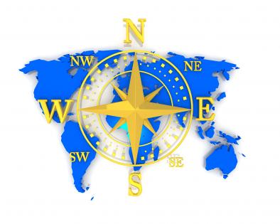
Compass with directions on world map stock photo




Try Before you Buy Download Free Sample Product
 Impress Your
 Audience
 100%
100% Editable
 Save Hours
 of Time


Leave the design work to us. Our Compass With Directions On World Map Stock Photo are working overtime to keep your presentations fresh.
People who downloaded this PowerPoint presentation also viewed the following :
Compass with directions on world map stock photo with all 1 slides:
Our Compass With Directions On World Map Stock Photo are exclusively crafted. They can be alluringly awesome.
FAQs for Compass with directions on world
So basically, compass roses were like the GPS of old sailing - they showed all 32 wind directions sailors used to navigate. Every nautical chart had these intricate hand-drawn designs that helped crews communicate directions and plot their routes. Pretty cool craftsmanship honestly. Before this standardized system, long-distance navigation was way trickier. Ships could finally maintain consistent bearings across entire voyages, which totally revolutionized global trade and exploration. If you're ever looking at historical maps, those compass layouts will help you understand how sailors actually got around back then.
So compass roses started pretty basic - just your main directions. Medieval ones had maybe 8-12 points, then Renaissance mapmakers went absolutely nuts with fancy 32-point designs covered in decorations and religious stuff. That fleur-de-lis north pointer? Been around since like the 1400s and honestly never gets old. Ships still use the traditional 32-point system today, but pilots just go with simple 360-degree markings instead. Oh and if you're ever designing navigation stuff - seriously stick with what people know. Wrong turn at sea isn't like missing your exit on the highway.
So basically a compass rose shows the main directions - N, S, E, W - plus the in-between ones like NE and SW. Most have degree markings around the edge, usually every 5° or 10°. The fancy ones get really detailed with all 32 traditional compass points, which is honestly overkill for most people. You'll notice they often have decorative stuff too - like that fleur-de-lis thing pointing north because old map makers apparently loved their flourishes. When you're actually using one, just focus on those degree numbers since they're way more accurate for navigation than trying to remember what "north by northeast" means.
Oh man, this stuff is actually really cool! So like in Indigenous North American cultures, east means new beginnings while west is all about endings and reflection. Chinese feng shui does something totally different though - north is for your career path, south for fame. Colors get thrown in too, which I never knew until recently. Red represents south in Chinese tradition, but Native Americans use white for north. Wild how the same directions mean completely different things, right? Just make sure you research whatever culture you're working with first so you don't mess anything up.
Dude, the compass rose is a total lifesaver for chart work. Makes plotting courses so much faster since you can just align your parallel rulers with it to get true and magnetic bearings from anywhere on the chart. Both directions are right there, plus the magnetic variation for that area - no more doing math in your head every time. Honestly wish I'd figured this out sooner when I was starting out. One thing though - always double-check if you're working with true or magnetic bearings before you start calculating. Easy mistake to make but it'll mess up your whole route.
Put compass roses in the corners or make them subtle watermarks behind your slides. The nautical ones honestly look way better than those basic arrows everyone uses. You can get creative with them too - use the directional points to organize sections or slide flow. When you've got maps or regional stuff, stick the compass near those visuals to show spatial relationships better. Oh and make them semi-transparent! Otherwise they'll clash with your actual data. They're surprisingly good as nav elements if you think about it.
So compass roses are pretty straightforward once you get the hang of them. You've got your basic N, S, E, W directions, plus the diagonal ones like NE and SW. The north pointer usually has this fancy fleur-de-lis or decorative arrow - honestly, it's kind of extra but looks cool. Most have degree markings around the edge for when you need to be super precise. Some go overboard and include stuff like NNE or SSW too. Next time you're staring at a map trying to figure out which way is what, just find that compass rose first. Makes everything click way faster.
Oh yeah, digital compass roses are so much better than those old decorative ones on paper maps! You can actually click on them to rotate your view or switch between magnetic and true north. Plus they update automatically based on where you are and show real-time magnetic declination - which honestly I never paid attention to until recently. When it's in the way, just hide it completely. The old ones just sat there looking fancy but doing nothing. Try clicking on that little compass icon next time you're on Google Maps or whatever - there's probably stuff you didn't know it could do.
So the compass rose is basically your directional guide - shows north, south, east, west. You'll line up the needle with magnetic north on the rose, then spin your map to match. That's how you orient everything to the real world around you. Super helpful for spotting landmarks and plotting where you're headed. Honestly, I've seen people get completely turned around because they trusted their instincts over the compass - don't be that person lol. Even when you can barely see anything, the rose keeps you on track. Way more reliable than guessing.
Start with treasure hunts around the classroom - kids go crazy for the whole pirate thing, honestly. Have them use compass roses to find "buried treasure" or describe where stuff is compared to landmarks. Once they get that down, move to real topographic maps. Plot routes, figure out cardinal vs intermediate directions, that sort of thing. Gets them actually handling maps instead of just staring at worksheets. You can also have them create their own compass roses for made-up places or look at how different cultures show directions. My kids always retained way more when they could physically work with the maps rather than just memorize theory.
Oh totally! Typography ones are super cool - like making the N, S, E, W letters into the actual design. Watercolor versions look amazing too, almost like actual paintings. You could go minimalist with just clean lines, or get weird with negative space. For digital stuff, make it interactive maybe? Really depends what vibe you're going for though - sleek and modern for tech projects, hand-drawn for travel themes. Vintage nautical is always a safe bet. I'd sketch out a few different ideas first before you commit to one.
Yeah, GPS kinda killed the compass rose for most people, but they're actually still around more than you'd expect. Marine charts and aviation maps still use them all the time. Even some digital apps have them for quick direction reference. Honestly, sailors and pilots swear by them when their electronics crap out - which apparently happens way more often than I realized. The magnetic declination stuff is still super useful for actual compass work too. Your phone's fine for finding coffee shops, but if you're doing any real navigation you'll probably run into these things.
Okay so the tricky part is that your compass doesn't actually point to the North Pole - it points to magnetic north, which is totally different. This difference is called magnetic declination and it changes depending on where you are. Could be just a few degrees off or like 20+ degrees, which is honestly a huge deal when you're trying to navigate. Plus the magnetic poles drift every year (kinda crazy right?), so older maps get less reliable. You'll need to look up the current declination for your specific area before trusting your compass. Don't just wing it.
So the compass rose shows you where north is on your map - pretty basic but crucial for getting oriented. Just line it up with your actual compass or use it to figure out directions between stuff. Like, is that trail going northeast or is the river flowing south? Sometimes it's not super obvious from just eyeballing the map layout. Oh and don't confuse it with the scale bar - that's totally separate. I always check the compass rose first before I start analyzing all the other details. Saves you from getting turned around later when you're actually out there.
Oh totally! The compass rose works amazing for this stuff. You know how everyone instantly gets what it means - finding direction, making big choices, that whole thing. I've watched speakers crush it by using the different points as core values or showing multiple paths forward. Works whether you're talking about actual exploration or just life decisions. Super versatile honestly. It taps into that basic human thing where we all need to know where we're headed. Perfect when you want to show options or hammer home why having clear purpose matters. Plus the visual is so clean and recognizable.
-
Amazing product with appealing content and design.
-
Informative design.