


Philippines Map Showing Highlighted Luzon Islands




Try Before you Buy Download Free Sample Product
 Impress Your
 Audience
 100%
100% Editable
 Save Hours
 of Time


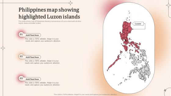
This slide shows map of Philippines showing marked areas of Luzon island with all other region, areas and water bodies.
People who downloaded this PowerPoint presentation also viewed the following :
Philippines Map Showing Highlighted Luzon Islands with all 9 slides:
Use our Philippines Map Showing Highlighted Luzon Islands to effectively help you save your valuable time. They are readymade to fit into any presentation structure.
-
Philippines Map Showing Highlighted Luzon Islands
-

Philippines Map Showing Highlighted Luzon Islands
-

Philippines Map Showing Highlighted Luzon Islands
-

Philippines Map Showing Highlighted Luzon Islands
-

Philippines Map Showing Highlighted Luzon Islands
-

Philippines Map Showing Highlighted Luzon Islands
-

Philippines Map Showing Highlighted Luzon Islands
-

Philippines Map Showing Highlighted Luzon Islands
-

Philippines Map Showing Highlighted Luzon Islands
FAQs for Philippines Map Showing
Luzon's key geographical features include the Sierra Madre mountain range along the eastern coast, the Central Luzon plain, Manila Bay, Lingayen Gulf, and the Bicol Peninsula extending southeast. These diverse landscapes enable varied agricultural production, urban development, and economic activities, with many businesses and government agencies finding that Luzon's geographic diversity supports multiple industries from farming to manufacturing.
Luzon's map prominently displays major urban centers like Manila, Quezon City, and Cebu through distinct markers, population density indicators, and transportation networks that connect key economic zones. These visual representations enable businesses, government planners, and investors to identify strategic locations for expansion, resource allocation, and market penetration, ultimately delivering enhanced decision-making capabilities for regional development initiatives.
Luzon maps illustrate cultural diversity through distinct provincial boundaries showcasing varying languages, ethnic groups, traditional practices, and historical influences across regions. From Ilocano-speaking northern provinces to Tagalog-dominated central areas and Bicolano southern regions, these geographical demarcations highlight linguistic diversity, indigenous communities, and colonial heritage patterns, ultimately enabling researchers, educators, and policymakers to understand cultural distribution for targeted community engagement and development strategies.
Transportation routes on Luzon's map connect major cities through a comprehensive network of highways, railways, airports, seaports, and inter-island ferry systems. The North Luzon Expressway and South Luzon Expressway streamline connectivity between Metro Manila and provincial centers, while the Philippine National Railways and regional airports enhance accessibility, ultimately enabling efficient movement of goods, services, and people across the island's diverse economic zones.
Luzon's natural landmarks include Mount Mayon with its perfect volcanic cone, Banaue Rice Terraces, Taal Volcano and Lake, Hundred Islands, and the Cordillera mountain ranges. These geological and agricultural wonders drive significant tourism revenue by attracting adventure seekers, cultural enthusiasts, and nature photographers, while supporting local economies through hospitality services, guided tours, and cultural preservation initiatives, ultimately establishing the Philippines as a premier Southeast Asian destination.
Elevation representation on Luzon maps reveals how mountainous areas like the Cordillera Central create cooler temperatures and higher rainfall, while lowland regions experience warmer, more humid conditions. These topographical variations enable diverse agricultural zones, with mountain provinces supporting temperate crops like rice terraces and vegetables, while coastal plains facilitate tropical agriculture, ultimately allowing farmers and agricultural businesses to optimize crop selection and maximize regional productivity.
Luzon's historical landmarks include Intramuros in Manila, Vigan's colonial architecture, Corregidor Island, Banaue Rice Terraces, and various Spanish churches, each representing distinct periods from pre-colonial civilization through Spanish colonization to World War II. These sites tell compelling stories of indigenous ingenuity, colonial transformation, wartime resistance, and cultural preservation, ultimately delivering rich educational content that enhances understanding of Philippine heritage and regional development.
Educators can use Luzon maps to teach Philippine geography by highlighting major cities, mountain ranges, river systems, and provincial boundaries, while incorporating historical lessons about Spanish colonization routes, World War II battles, and indigenous settlements. Through interactive activities like tracing trade routes, identifying natural resources, and mapping cultural regions, students develop spatial awareness and historical context, ultimately enhancing their understanding of how geography shapes Filipino culture and development.
The bodies of water surrounding Luzon—including Manila Bay, Lingayen Gulf, and the South China Sea—serve as crucial economic corridors that facilitate maritime trade, fishing industries, port development, and coastal tourism. These waterways enable strategic shipping routes, support agricultural irrigation systems, and drive regional commerce, with many coastal provinces finding that proximity to these waters delivers enhanced connectivity, resource access, and economic opportunities that accelerate overall development.
Natural disaster risk areas on Luzon maps inform residents and local governments by identifying flood zones, earthquake fault lines, volcanic hazard areas, typhoon paths, and landslide-prone regions through color-coded systems and detailed geographical markers. These comprehensive mapping tools enable communities to develop strategic evacuation plans, implement targeted infrastructure improvements, and establish early warning systems, while local governments can allocate resources more effectively, ultimately enhancing disaster preparedness and reducing casualties across the island.
Luzon's administrative divisions include the National Capital Region, Central Luzon, CALABARZON, Bicol Region, and the Cordillera Administrative Region, each encompassing multiple provinces with distinct economic and cultural characteristics. These divisions streamline government operations, resource allocation, and development planning, with regions like NCR driving financial services, Central Luzon supporting manufacturing, and CALABARZON facilitating logistics, ultimately enabling targeted policy implementation and balanced regional growth across the Philippines' largest island.
Digital mapping technology enhances understanding of Luzon's geography by providing real-time topographical data, satellite imagery analysis, GPS precision mapping, and interactive visualization tools that reveal detailed terrain patterns, urban development trends, and natural resource distributions. Through advanced GIS systems, government agencies, urban planners, and environmental researchers streamline land management decisions, optimize infrastructure development, and deliver more accurate geological assessments, ultimately enabling better disaster preparedness and strategic regional planning across the island's diverse landscapes.
Luzon's ecological zones include tropical rainforests, montane forests, grasslands, wetlands, and coastal mangroves, each supporting distinct flora and fauna populations. These diverse ecosystems contribute to biodiversity by providing specialized habitats for endemic species, migration corridors for wildlife, and critical breeding grounds, with many conservation organizations finding that this ecological variety makes Luzon essential for regional biodiversity preservation and sustainable ecosystem management.
The Luzon map reveals indigenous communities concentrated in mountainous regions like the Cordilleras, where Igorot peoples maintain ancestral domains, and in remote areas of Aurora and Quezon provinces. These territorial distributions reflect historical settlement patterns, with many communities finding that geographic isolation has helped preserve cultural autonomy while presenting both challenges for economic integration and opportunities for sustainable development partnerships.
Landscape analysis from Luzon maps assists urban planning by identifying optimal locations for development, assessing natural hazard risks, evaluating transportation corridors, and determining sustainable resource allocation patterns. Urban planners across Philippine cities leverage this geographic intelligence to design resilient infrastructure networks, minimize environmental impact, and optimize utility placement, ultimately delivering cost-effective development strategies and enhanced community resilience.
-
Time saving slide with creative ideas. Help a lot in quick presentations..
-
Easily Understandable slides.