


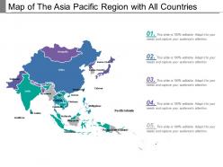
Map of the asia pacific region with all countries





Try Before you Buy Download Free Sample Product
 Impress Your
 Audience
 100%
100% Editable
 Save Hours
 of Time


Guide folks on dealing with complications through our Map Of The Asia Pacific Region With All Countries. Enable them to handle intricacies.
People who downloaded this PowerPoint presentation also viewed the following :
Map of the asia pacific region with all countries with all 5 slides:
Involve folks in carefree celebration with our Map Of The Asia Pacific Region With All Countries. Enable them to display a bit of joie-de-vivre.



FAQs for Map of the asia pacific region
So basically the Pacific Ring of Fire is what made all those crazy volcanic islands and mountain chains. The Himalayas are obviously massive too. Monsoons control everything agriculture-wise - like, they literally determine where people can grow stuff and live. Indonesia and the Philippines have thousands of islands each, which is honestly just insane to think about. Most big cities ended up in river deltas and coastal areas because that's where the good farmland is. Oh and if you're studying trade routes, those coastal spots are where all the action happened historically.
So basically, political boundaries mess with economic cooperation but also create opportunities. Countries like Japan and South Korea operate totally differently from China or Vietnam, which makes trade talks a nightmare sometimes. The South China Sea drama? Yeah, that freezes partnerships for years. But here's what's weird - countries end up cooperating anyway through groups like ASEAN and RCEP because they're literally neighbors and share waters. I'd honestly just follow the political drama if you want to predict trade patterns. Geography forces cooperation even when politics don't.
Asia Pacific shipping routes are insane - they carry like 60% of all global trade. The Strait of Malacca and South China Sea are these massive chokepoints where tons of cargo passes through every single day. Singapore and Hong Kong basically turned themselves into powerhouse economies just by being perfectly positioned ports. It's wild how much commerce flows through there. Oh, and disruptions hit supply chains super fast - we're talking days, not weeks. Definitely something to keep tabs on for your project since these waterways pretty much keep the global economy humming along.
Dude, the cultural differences across Asia Pacific are wild and honestly make or break your trip depending on how you roll with them. Japan's got all these precise etiquette things, while Thailand's super chill and welcoming. Food, languages, social stuff - it's all over the map. What flies in Australia could totally offend someone in conservative parts of Indonesia (learned that one the hard way lol). Each country needs its own research beforehand. But that's kinda the whole point, right? The diversity makes it incredible to explore. Just embrace the chaos instead of expecting everything to be the same.
Topo maps are your best friend for finding resources in Asia Pacific - seriously underrated tool. Oil and gas hang out in those flat sedimentary basins, while minerals like copper hide up in the mountains where all the tectonic drama happened. Papua New Guinea's crazy steep terrain? Perfect for mining ops. You'll want to match elevation data with geological surveys though - that's where the magic happens. The Philippines has similar patterns if you know what to look for. It's pretty cool how terrain tells the whole story about what's buried underneath.
So basically Asia Pacific cities have exploded in size, especially along coasts and river areas - Tokyo, Shanghai, Jakarta, you know the ones. Farmland got swallowed up super fast, often without much planning, which is why you get these crazy sprawling megacities. The speed is honestly insane - some of these places were way smaller just 30 years ago. People moved from rural areas inland to these urban hubs for jobs. Creates tons of opportunities but also infrastructure nightmares. Oh, and if you're looking at development patterns, definitely start with coastal regions since that's where all the action is.
Dude, the environmental stuff there is honestly pretty scary. Beijing and Delhi's air quality is brutal - you literally can't breathe some days. Southeast Asia's losing forests fast, plus water shortages are becoming a real thing. Climate change is hitting them way harder than other places - sea levels rising, crazy weather patterns. Oh and the plastic pollution in the oceans? Don't even get me started on that mess. A lot of countries are industrializing super quickly but skipping the environmental protections part. It's all connected too - these issues mess with economics and push people to migrate. Something to definitely think about if you're doing research there.
So basically, colonial powers totally shaped what Asia Pacific looks like today. Britain, France, and Japan just drew lines wherever they wanted - that's how we got India splitting into three countries, or Korea getting divided after Japanese occupation. WWII kicked off this whole decolonization thing that created tons of new nations. Then the Cold War came along and pretty much locked those boundaries in place. It's actually kind of wild how much those old divisions still matter - you can see it in which countries get along versus the ones that still have beef with each other. Makes mapping trade partnerships way more complicated than it should be.
Dude, the age thing is wild across Asia Pacific right now. Japan and South Korea are basically running out of workers while Indonesia and the Philippines are still super young. China's population just hit its peak which is... honestly kind of mind-blowing when you think about it. Cities are exploding everywhere too - like, imagine adding a whole NYC worth of people every year just from rural migration. The urban growth is insane. If you're doing any market planning there, you really can't ignore how different these age structures are between countries. It'll totally mess up your assumptions otherwise.
Dude, those Asia Pacific maps are wild when you see all the colors for different language families and ethnic groups. Indonesia alone has like 700+ languages - it's crazy. Papua New Guinea's the same way with all those tribal areas scattered everywhere. The maps show population density too, plus you can see how colonial borders just sliced right through where people actually lived. Honestly though, if you're doing research on anything over there, get yourself a decent ethnolinguistic atlas. Way better than guessing where cultural boundaries actually are (spoiler: they're usually not where you think).
Dude, this is wild to think about. Sea levels rising means Pacific islands are literally gonna vanish from maps - Indonesia and the Philippines are screwed. Coastlines everywhere will look totally different. Monsoon patterns are shifting too, so agricultural zones won't be where they used to be. Desert boundaries are moving, and we'll have new flood zones plus drought areas popping up. Pretty depressing honestly. Oh, and forget static maps - you'll need dynamic tools that can show climate projections over time. Maps are basically becoming movies now instead of photos.
So basically they're using satellite stuff like Landsat and Sentinel these days, plus GPS for the exact positioning. LiDAR's pretty cool too - creates insanely detailed elevation maps. Drones help cover spots that are hard to reach. GIS software crunches all the data together. Oh, and lots of countries let regular people update maps through OpenStreetMap now, which is honestly kind of genius. I'd check a few different sources though since some regions get updated way more often than others. The tech varies a lot depending on where you're looking.
So ASEAN basically lets smaller countries gang up against China instead of getting steamrolled individually. Think of it like your work team negotiating raises together - way more effective than going solo. Member countries coordinate on trade stuff and push back on South China Sea disputes as one unit. Plus all that economic interdependence makes actual wars super expensive for everyone involved. Honestly, it's pretty smart strategy. Keep an eye on their summit announcements though - they usually hint at major power shifts happening in the region.
Maps are basically lifesavers for disaster prep in Asia Pacific. Think about it - you've got typhoons hitting the Philippines, tsunami zones around Japan, all those crazy fault lines everywhere. Local governments rely on mapping to figure out where to stash emergency supplies and plan evacuation routes before disasters strike. The geography there is honestly nuts with all the islands and monsoon patterns, so having accurate maps is way more critical than most places. If you're working in that region, definitely grab the latest hazard maps for your area. Pro tip: keep digital copies saved offline too, because you never know when connectivity goes down.
Dude, maps are a game-changer for infrastructure planning over there. They show terrain, population clusters, what's already built, and where you definitely shouldn't build - like flood zones or sketchy ground. You'll spot the best highway routes and figure out which areas desperately need power grids. Cross-border connections are huge too, especially with all those islands in Southeast Asia (the coastlines alone are insane). Honestly, GIS tools that stack demographic and geographic layers are your best bet. That way you're planning for both current needs and future growth. Pretty straightforward once you dive in.
-
Best Representation of topics, really appreciable.
-
Great designs, really helpful.