


World map of continents and seas




Try Before you Buy Download Free Sample Product
 Impress Your
 Audience
 100%
100% Editable
 Save Hours
 of Time


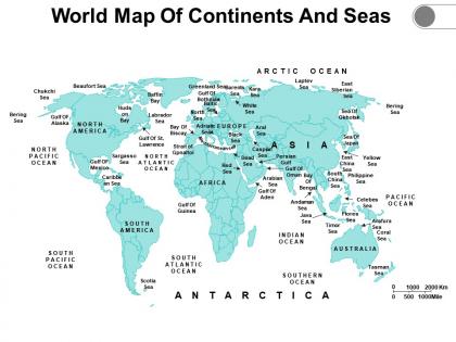
Be it for educational purposes or business, our World Map Of Continents And Seas PowerPoint Presentation Slide proves to be the best choice for every unique need and requirement. This PPT template consists of all the accurate information designed by our professionals. This PPT slide will help you create a data-driven business strategy. You can clearly display and demarcate each sea, ocean, and continent by taking the aid of our content-ready PPT layout. Select our PPT theme to visually represent the locations and geographics and grab the attention of the audience. Identify the target market and audience by employing this PPT visual. Educational institutions and students can take advantage of this PPT graphic for learning and teaching purposes. Our world map PPT design is an important tool for your research purposes. Click the download button and make this well-curated PowerPoint your source to examine the entire world map easily and accurately.
People who downloaded this PowerPoint presentation also viewed the following :
Content of this Powerpoint Presentation
There was a time when people depended solely on physical maps for directions, shapes and sizes of countries, features and distance between places. Over time, digitalization made inroads in all spheres of life and even in the representation of maps. Nonetheless, its importance cannot be understated. Throughout history, mankind had relied on maps to negotiate life and create waves of progress for businesses.
So much so that when Kofi Annan, former UN general secretary, said, said “Knowledge is power. Information is liberating”, he must be talking about maps because maps have provided us with information and knowledge we need to make decisions.
The World Map with Continents and sea helps in understanding the Earth's surface layout. It assists sailors, pilots and travelers in planning routes and comprehending the layout of water bodies and land masses.
It also helps in studying weather patterns, climate change and ocean currents.
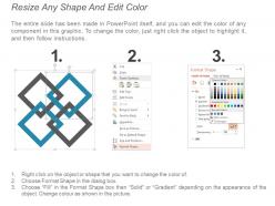
This PowerPoint Slide, curated by SlideTeam professionals, is 100% editable and customizable. You can change the color, size and the orientation of any element or text.
Let’s explore.
Template: World Map of Continents and Seas
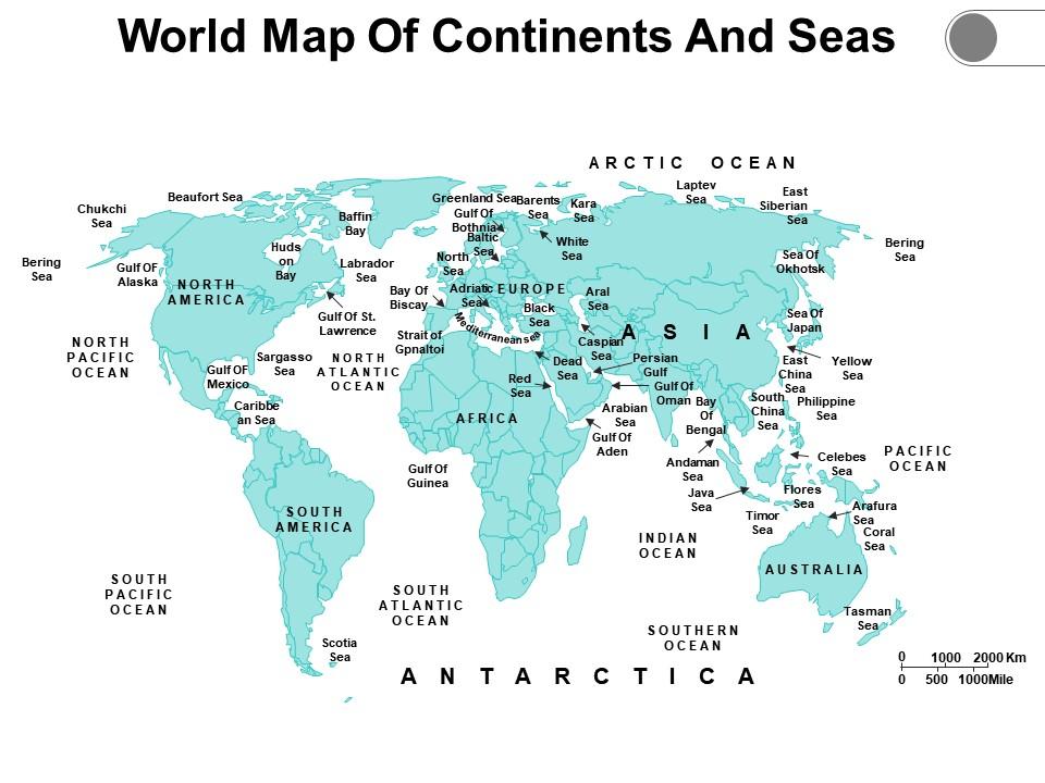
This Template is a reference to highlight landforms, waterbodies, position of cities, etc. It can be used for educational purposes in schools or universities, for any business strategy or for military purposes. It is a great addition to any geography lesson which makes learning fun for the student and helps in retention. There are additional slides in this template which comprises instructions to edit the slide, resize shade, edit color and use icons.
Explore Beyond Borders
This World Map is a reference for geopolitical analysis which aids in understanding international relations and boundaries. It can be used in urban planning, global trade routes, shipping lanes and infrastructure development. These advances in cartography and digital mapping technologies have enhanced accuracy and details of World maps.
World map of continents and seas with all 5 slides:
Deliver the goods with our World Map Of Continents And Seas. Enhance your teams faith in you.


FAQs for World map of
So basically three big things shape landscapes: climate, tectonic stuff, and elevation. Climate controls rain patterns and temps, which totally drives erosion and what plants can grow. Tectonic forces build mountains and carve out valleys through all that plate movement. Then elevation messes with local weather and how water flows downhill. Don't forget ocean currents and latitude though - especially near coasts where proximity to water is honestly a game changer. They all influence each other too, so you can't really separate them. Just map out these elements first and you'll get why any region looks the way it does.
Honestly, climate shapes literally everything we do. Where people live, what they grow, how they build houses - even daily stuff like when you wake up. Middle Eastern countries built all this cool underground architecture because of the heat, while Scandinavian folks became crazy good at heating tech. Tropical places? Their whole farming thing revolves around monsoon seasons. It's wild how humans just... adapt, you know? And here's what's really cool - climate doesn't just limit what's possible, it actually pushes people to innovate in ways you'd never think of.
So tectonic plates basically build mountains when they crash into each other - that's how we got the Himalayas. Crazy right? When they pull apart, you get new ocean floor and those rift valleys. Earthquakes and volcanoes are just the flashy stuff we actually notice, but the real action happens super slowly over millions of years. I swear, almost every major landscape feature you can think of traces back to these plate movements. Valleys, ocean basins, mountain ranges - it all comes down to rocks playing bumper cars in slow motion.
Honestly, rivers are why civilizations exist at all. Fresh water, fertile soil when they flood, plus easy transport for trading stuff. Egypt wouldn't be Egypt without the Nile, you know? Same with how the Mississippi basically built American trade. Most big cities are still on rivers today - shipping, factories, water supply. Climate change is screwing with river patterns now though, so farmers and cities have to figure out new ways to deal. But seriously, if you want to understand how any place developed, just look at where the water flows. That's your roadmap right there.
Natural resources can totally make or break a country's economy. Saudi Arabia and Norway hit the jackpot with oil, but then you've got places like the DRC that are sitting on tons of wealth but still can't get their act together because of corruption and crappy infrastructure. Venezuela's a perfect example of what happens when you put all your eggs in one basket - oil prices tank and suddenly your whole economy's screwed. Actually, it's kinda crazy how much your location determines your fate sometimes. The smart countries diversify so they're not completely vulnerable to market crashes. Geography really is everything in economics.
Dude, it's everywhere once you notice it! Different cultural groups basically reshape neighborhoods to fit their needs - think ethnic markets, specific building styles, community spaces. Climate and landscape influence which cultures end up where too. Like, immigrant communities often settle near ports (makes sense, right?), and you'll see how people adapt their architecture to local weather. Economic factors drive a lot of cultural mixing. Honestly, the whole thing is pretty cool to observe. Next time you're out, just look around and try connecting the dots between geography and culture in your area.
Globalization's wild because it makes places more similar AND more different at once. McDonald's everywhere, same chain stores - total homogenization. But then locals fight back twice as hard to keep their traditions alive. It's like people get protective when they see their culture threatened, you know? I've noticed this creates these fascinating hotspots where global meets local. That cultural pushback thing is real - communities double down on what makes them special. If you're studying this stuff, focus on those clash zones. That's where geography gets messy and interesting.
Maps are basically propaganda with pretty colors. Think about it - whoever draws them controls the narrative. Colonial maps made Europe look huge while shrinking Africa and Asia. Some countries get centered, others shoved to the edges. Even today, check out how disputed territories get colored or which cities actually get labeled. The Mercator projection? Total size distortion that we just accept as normal. Something that feels so factual is actually someone's specific viewpoint. When you're looking at any map, just ask yourself whose story it's really telling.
Mountains are huge - they block weather systems and create those rain shadow effects. Latitude basically controls how much sun hits different areas, which drives everything else. Oceans are the real MVPs though, moderating temps and pumping moisture into the air. It's crazy how elevation changes things too since it gets colder as you go up. I always think about how different the east and west sides of the Rockies are - same mountain range, totally different climates. Ocean currents carry warm/cold water around and mess with coastal weather patterns big time.
So basically, we mess up the environment in three big ways: wrecking habitats, pollution, and throwing off natural cycles. Cities and dams break apart ecosystems that took forever to form. Agriculture is honestly the worst offender - it cuts up wildlife areas and dumps chemicals everywhere. Then you've got urban sprawl creating these weird heat bubbles and extra water runoff. Forests get cleared, which speeds up erosion and makes climate change worse. Here's the thing though - all this stuff builds up over time. Any new development project? You can't just look at that one spot. The ripple effects spread way beyond what you'd expect.
So population density is all over the place - Monaco's packed with like 26,000 people per square kilometer while Canada's got these massive empty areas. Makes sense though. People want water access, decent weather, flat land for crops and cities. That's why everyone crowds around coasts, rivers, fertile areas and avoids deserts or freezing places. Cities are obviously way denser than rural spots. Honestly, if you're looking at demographic stuff, just check the geography first - it'll explain most settlement patterns pretty quickly. Mountains and harsh climates = fewer people, basically.
So climate change is literally redrawing the map right now. Sea levels are rising and wiping out coastlines. Rain patterns are all messed up - deserts where farms used to be, weird weather everywhere. Animals can't keep up and are either moving or dying out. The Arctic melting thing is wild though - like, we're getting new shipping lanes but polar bears are screwed. It's all happening way faster than anyone thought it would. Oh, and NASA has this climate tracker that shows what's happening in your area specifically if you want to see how bad it is where you live.
So geographic stuff basically works like natural roadblocks, you know? Mountains, deserts, big water bodies - they either force people to go around them or block migration completely. The Himalayas have always separated South and Central Asia, while the Sahara creates totally different migration patterns across Africa. Rivers are weird though - sometimes barriers, sometimes highways for movement. Coastal areas usually become population hubs since they're easier for travel. Oh, and if you're looking at migration patterns in your area, map out the major geographic features first. They'll explain why people ended up where they did.
Mountains are crazy biodiverse - way more than you'd expect. Basically they create these mini climate zones stacked on top of each other. Hot and tropical down low, then it gets cooler as you go up, until you hit basically Arctic conditions at the top. All these different species just pile up in one area since each altitude has its perfect niche. Plus mountains mess with weather patterns big time - they block air masses and create those dry "rain shadow" areas on one side. I swear if you look at any biodiversity map, all the hotspots are clustered around mountain ranges. Makes total sense once you think about it.
Dude, geography isn't just paper maps anymore - we've got GPS, satellite images, real-time weather data, the works. Your phone can pinpoint where you are anywhere on the planet. Street View lets you virtually walk around places you'll probably never visit (which is honestly kind of addictive). Researchers use GIS mapping to analyze patterns that would've been impossible to spot before. The amount of geographic info available now is insane compared to even ten years ago. Oh, and try layering different data on Google Earth next time you're planning a trip - you can dig up some pretty cool stuff about places.
-
Best Representation of topics, really appreciable.
-
Topic best represented with attractive design.