


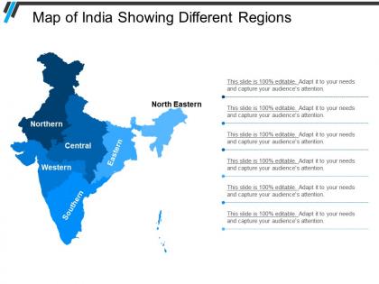
Map of india showing different regions




Try Before you Buy Download Free Sample Product
 Impress Your
 Audience
 100%
100% Editable
 Save Hours
 of Time


Boost the inherent confidence of folks with our Map Of India Showing Different Regions. It will inspire the demoralised.
People who downloaded this PowerPoint presentation also viewed the following :
Map of india showing different regions with all 5 slides:
Fashion an ending better than the beginning with our Map Of India Showing Different Regions. Bring about a befitting culmination.

FAQs for Map of india
So basically, India's geography breaks down into these super clear chunks once you know what to look for. The Himalayas wall off the north - pretty obvious border there. Down south you've got the Deccan Plateau, which is just this massive raised area that takes up most of the peninsula. Western coast has the Arabian Sea plus those Western Ghats mountains running alongside it. Eastern side? Bay of Bengal with the Eastern Ghats, though honestly they're not nearly as impressive. Oh, and there's this huge flat Indo-Gangetic Plain stretching across the north-central part. Trust me, once you spot these on a map everything clicks.
Dude, India's regional maps are like looking at cultural fingerprints spread across the country. You can see how languages cluster around state borders, and religious communities create these distinct patterns everywhere. Punjab's got those Sikh majorities, while down in Kerala you'll find Christian communities mixed with Hindus. Migration routes and old trade paths basically shaped where people ended up settling. Food traditions and festivals create their own zones too - sometimes they don't even match up with the actual political boundaries, which is kinda fascinating. Honestly, you need to layer multiple maps to really get the full picture of how culture and geography connect.
So basically, the northern plains are all about farming - wheat, rice, that kind of stuff. Gujarat and Maharashtra? Total industrial zones with textiles and manufacturing. Southern India is where all the tech companies set up shop (Bangalore, Hyderabad, Chennai obviously). Eastern states do a lot of mining and steel production. Coastal areas are big on fishing and ports, which makes sense. Oh, and there's jute production too - honestly forgot that was still a thing! If you're thinking about expanding somewhere, just match what each region's good at with what you actually need.
So basically climate is like the foundation for how India's regions work. Monsoons create these crazy different zones - you've got the lush Western Ghats right next to the bone-dry Thar Desert. Temperature does its thing too with cool Himalayan areas up north and tropical regions down south. What's wild is how this affects everything - crops, how people live, even languages that developed over time. Honestly, next time you look at a map of India's regions, just follow the climate patterns first. Makes way more sense why the boundaries are where they are.
So basically three big things shaped India's borders. The British set up a bunch of provinces back in the day - typical colonial stuff. Then 1947 happened and everything got messy with Partition when Pakistan and Bangladesh broke off. The real game-changer though was 1956's States Reorganisation Act. That's when they redrew everything along language lines, which honestly makes way more sense than the random British setup. That's why you'll notice most states match up with major language groups. Pretty clever actually - it explains a lot about cultural and economic patterns you see across different regions today.
That India linguistic map is honestly super useful! You can see how languages cluster together geographically - like Indo-Aryan languages dominating the north while Dravidian ones stay mostly in the south. The borders between regions are where it gets really interesting though. People there usually speak 2-3 languages no problem. Smaller tribal languages tend to hide out in mountainous areas or forests, which makes sense if you think about it. Geography basically shaped how people communicated for centuries. If you're doing research, it'll show you exactly where to look for specific language communities. Way better than trying to figure it out from random sources online.
So basically you'll see darker areas or bigger dots marking the major cities - Mumbai, Delhi, Bangalore, all that. Rural spots show up way lighter. Honestly the difference is pretty crazy when you look at it. Most cities cluster around the coasts and up north in the plains. Maharashtra and Tamil Nadu are packed with urban areas compared to like the northeast states which are still mostly rural. Oh and definitely check the legend first or you'll be guessing what everything means. The population density really tells the whole story about where people actually live.
So basically, rivers and mountains act like natural borders that divide up Indian regions. The Ganges, Narmada, and Krishna rivers often mark state boundaries. Mountain ranges like the Western Ghats and Himalayas do the same thing - they create obvious divisions between areas. Makes sense if you think about it, since these features naturally separate communities and cultures. The Deccan Plateau is a perfect example, surrounded by mountain ranges. Honestly, geography class would've been way more interesting if they explained it this simply. When you're studying maps, just follow the natural features first and you'll see why the borders are where they are.
Oh maps are so good for this! Kids actually remember stuff when they can point to places instead of just reading boring lists. Have them research different festivals or foods from each region, then present using the map. Works great for history too - tracing old trade routes or talking about independence events. My favorite thing is having them plan fake travel routes between states (gets them thinking about geography without realizing it). You could do monsoon patterns, population stuff, economic zones. Honestly way better than textbook memorization.
Dude, India's regional gaps are wild when you look at the numbers. States like Maharashtra and Karnataka are crushing it economically while northern/eastern areas lag way behind in GDP and infrastructure. People basically flood into cities like Mumbai and Bangalore chasing jobs, which makes those places even more insane to live in. Honestly, the contrast is pretty jarring when you see it mapped out. For your work stuff, just remember that strategies working in Chennai could totally bomb in somewhere like rural Bihar. The disparities affect everything from market potential to talent availability, so you can't really use a one-size-fits-all approach across regions.
So political boundaries are super clean-cut on maps - thick lines showing exactly where one state ends and another begins. Cultural stuff? Totally different story. They use these blended, gradient-looking areas because culture doesn't just stop at a border, you know? Like, people in border towns often share way more with their neighbors across state lines than with folks hundreds of miles away in their own state. You'll see overlapping patterns and softer shading instead of hard lines. Just make sure you check what kind of boundaries the map's actually showing before you draw any conclusions from it.
Honestly, just pick based on what you actually want to see. The Golden Triangle up north is classic for a reason - Delhi's Red Fort, the Taj Mahal, Jaipur's crazy palaces. Down south you've got incredible temples at Hampi plus Kerala's backwaters (which are genuinely stunning, not just Instagram hype). Mumbai and Goa beaches cover the west. East has Kolkata's Victoria Memorial and those famous Darjeeling tea gardens. Want tigers? Central India's your best bet, plus Khajuraho temples. The northeast is wild - Kaziranga rhinos and landscapes that'll blow your mind. What vibe are you going for?
GIS mapping and satellite stuff has completely changed how we can look at India's regions - way beyond just drawing state lines. Google Earth Engine and ArcGIS are pretty powerful for tracking everything from farming patterns to how cities are expanding. What's really cool is you can layer demographic and economic data right onto maps, plus get real-time updates on monsoons and population shifts. Honestly, the amount of data you can visualize now is kind of overwhelming. If you're just starting out, QGIS is free and perfect for playing around with different datasets on Indian maps.
Mapping India is honestly a nightmare for cartographers. The scale differences alone are crazy - Rajasthan is massive while some northeastern states are tiny, so getting consistent detail is basically impossible. Going from sea level to the Himalayas makes elevation tricky too. Cultural stuff gets messy because linguistic regions don't match administrative boundaries or cultural zones at all. Kashmir and other disputed areas add political drama that affects what you can even show. Oh, and the monsoon patterns change everything seasonally which complicates things further. Just be super specific about what you actually need the map for upfront.
So basically, maps change based on where people are moving and which areas are booming. Cities like Bangalore get way more detailed on newer maps because they've grown like crazy. Rural spots? Not so much attention. Population growth, people migrating for jobs, new industries - all that stuff makes mapmakers focus on certain regions more. You'll see new districts popping up or boundaries getting redrawn. Oh, and always check when your map was made! India changes fast, so a map from even 5 years ago might be pretty outdated for some areas.
-
Use of icon with content is very relateable, informative and appealing.
-
Use of different colors is good. It's simple and attractive.