


Blank Political Map Of India With State Borders


Try Before you Buy Download Free Sample Product
 Impress Your
 Audience
Editable
of Time


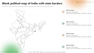
This slide shows outline political map of India with all 28 states and 8 union territories along with border of neighbouring countries.
People who downloaded this PowerPoint presentation also viewed the following :
Blank Political Map Of India With State Borders with all 9 slides:
Use our Blank Political Map Of India With State Borders to effectively help you save your valuable time. They are readymade to fit into any presentation structure.


FAQs for Blank Political Map Of India
So India's got 28 states and 8 union territories - that's the main stuff you'll need. The state boundaries are honestly what you'll use most, like Maharashtra, Karnataka, all those. Then there's international borders with Pakistan, China, Nepal, Bhutan, Bangladesh, and Myanmar. District boundaries exist too but they get super detailed depending on your map. Union territories like Delhi have this special admin status thing. I'd say start with state-level boundaries since that's what comes up most in political and business stuff anyway.
So India has 28 states and 8 union territories - basically states run themselves while union territories get controlled by the central government. States can make their own laws about stuff like schools and farming. Delhi's weird though, it's technically a union territory but acts more like a state? Anyway, the whole thing lets different regions keep their languages and cultures while staying unified as one country. Oh and if you want to follow Indian politics, focus on the bigger states first since they have way more influence. It's honestly a pretty smart system once you get it.
Delhi, Mumbai, Chennai, Kolkata - these places basically run Indian politics. Huge populations that vote together, plus urban voters actually show up and make noise about stuff. AAP's whole Delhi takeover is the perfect example of this. You've got all the media, business lobbies, and political machinery concentrated there too. Honestly, if you want to predict where elections are heading, just watch what the metros do first. Their voting patterns usually spread outward. Oh and the constituency influence is insane - these cities can swing entire state results because of their numbers.
Oh man, India's map has changed SO much since 1947! We started with like 14 states and now have 28 states plus 8 union territories. The massive overhaul was in 1956 - they basically redrew everything along language lines, which honestly made way more sense. Goa joined in '61. The northeast got totally restructured over the years. Telangana split off from Andhra Pradesh in 2014, and then there was all that drama with J&K in 2019. Just a heads up though - this stuff keeps changing, so if you're writing something current, definitely verify the numbers first!
So regional parties totally broke up the Congress-BJP thing at state level. Look at AIADMK in Tamil Nadu or TMC in Bengal - they own their states but still matter nationally. AAP's doing the same in Delhi now. Makes coalition politics way more common since national parties need these regional allies to actually govern. Honestly, Tamil Nadu politics is wild if you ever dive into that rabbit hole. Anyway, for your analysis I'd focus on how it creates stability through better representation but also makes things messier with all the alliance drama. It's basically changed everything.
So basically, India carved up its states around who speaks what language - that's why you get Telugu speakers in Andhra Pradesh, Tamil in Tamil Nadu, etc. The 1956 States Reorganisation Act made it official. But here's where it gets complicated (and honestly kind of fascinating) - caste still drives a lot of elections within those states. Religious minorities push for their own representation too. Tribal areas? They get special protections. My advice: always check the demographics first when you're looking at Indian politics. It'll explain why certain parties own specific regions and how those crazy coalition governments actually work.
So basically India's borders are like 90% determined by geography. The Himalayas create this massive natural wall up north against China, Pakistan, Nepal, and Bhutan. Rivers define a ton of boundaries too - you'll see it with the Radcliffe Line (though honestly that border's a complete mess). Coastlines obviously handle the eastern and western edges. Even state borders inside India follow rivers constantly - West Bengal, Assam, all of them. Oh and those disputed areas like Kashmir? Yeah, it's mostly because the geography makes everything super complicated. Mountains and rivers basically drew India's map before politicians ever got involved.
Look, constituencies are basically how India divides up political power. Each one elects a single rep, so mapping them out shows you which areas actually matter electorally. Some are way more important than others - Amethi and Varanasi get all the attention for a reason. You'll also see how demographics drive voting patterns and why certain regions always go for the same parties. Honestly, if you're trying to understand Indian politics, start with the key constituencies in swing states. That's where the real action happens, and it'll make the whole electoral picture way clearer.
So Union Territories are basically different from regular states. The central government runs them directly through appointed guys, not elected chief ministers like you'd see elsewhere. Most don't even have their own legislatures - Delhi and Puducherry are weird exceptions though. It's usually small places or ones that are strategically important, so New Delhi wants to keep a closer eye on things. Makes sense I guess. Chandigarh, Lakshadweep, Ladakh - they all work this way. Lieutenant Governors or Administrators handle the day-to-day stuff, but they answer straight to the President.
Dude, the smaller states totally get screwed over. Big ones like UP and Maharashtra hog all the attention and funding because they've got way more MPs in Parliament. Companies don't want to invest there either - they'd rather go where the markets are bigger, you know? It's honestly kind of unfair when you think about it. Check out the budget allocations sometime and you'll see what I mean. These smaller states get less money per person even though they usually need way more help with development stuff. Short answer: they're basically fighting an uphill battle against the political math.
Honestly, political maps are everywhere in civics education for good reason. Teachers love them because they make explaining our federal system so much easier - like showing students all 28 states and 8 union territories without everyone getting lost. They're perfect for breaking down electoral processes and regional differences too. Government campaigns use them constantly for voter education, helping people understand their constituencies. NGOs grab them for awareness drives since India's geography can be pretty overwhelming otherwise. I've seen how much clearer governance structures become when you've got a visual reference. Trust me, if you're doing any civic program, grab a decent political map - it'll save you tons of explanation time.
So basically, three big things shaped India's state borders. The 1956 States Reorganisation Act was huge - that's when they decided to organize states by language. You've got Tamil Nadu for Tamil speakers, Gujarat for Gujarati folks, etc. Obviously Partition in 1947 was massive too. Plus they had to figure out what to do with 562 princely states after independence, which was honestly a nightmare. Later on, some states got split up for political reasons - like Jharkhand breaking off from Bihar in 2000. If you're trying to make sense of why borders are where they are, just look at what language people speak there and when the state was created. That explains most of it.
So basically, political maps show the big stuff - states, territories, major boundaries you'd see on the news. Administrative maps get way more detailed with districts, blocks, all the smaller governing units. Political is like the overview version. Administrative breaks down how government actually works day-to-day, which honestly gets pretty granular. You'll see every subdivision and local unit. If you're doing research on governance or need to know jurisdiction stuff, go with administrative. It shows the real operational setup instead of just the headline divisions.
So the Election Commission doesn't actually draw constituency boundaries themselves - there's a separate Delimitation Commission that gets set up every few decades for this job. Last one was 2002, which feels like forever ago honestly. The EC basically feeds them all the voter data, population numbers, and administrative stuff so constituencies end up with similar population sizes. They handle local election boundaries too. Short sentences work better here. If you're digging into this topic, definitely check out the Delimitation Commission Act 2002 - it'll give you the whole timeline and process breakdown.
So Indian politics is wild because of all the languages - like 22 official ones plus hundreds more. States got carved up by language groups, so Tamil Nadu is for Tamil speakers, Punjab for Punjabi, you get it. Regional parties actually crush it because they know the local vibe way better than big national parties. Honestly, once you figure out which language group runs each state, voting patterns make total sense. It's like the whole system revolves around keeping these different cultural groups happy, which makes everything way more complicated than most countries deal with.
-
Fantastic collection of visually appealing PowerPoint templates. They certainly uplift the look of the presentation.
-
Definitely recommend SlideTeam to all who need help with PowerPoint presentations. Their design team can create anything you need.