Urban Planning And Land Parcel Management Geospatial Technology For Environment Conservation TC SS
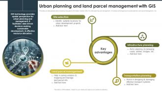
This slide provides glimpse about adopting Geographic Information System GIS for urban planning and management. It includes advantages such as site selection, land parcel management, etc.
You must be logged in to download this presentation.
 Impress your
 audience
Editable
of Time
PowerPoint presentation slides
This slide provides glimpse about adopting Geographic Information System GIS for urban planning and management. It includes advantages such as site selection, land parcel management, etc. Increase audience engagement and knowledge by dispensing information using Urban Planning And Land Parcel Management Geospatial Technology For Environment Conservation TC SS. This template helps you present information on four stages. You can also present information on Infrastructure Planning, Land Parcel Management, Transportation Planning using this PPT design. This layout is completely editable so personaize it now to meet your audiences expectations.
People who downloaded this PowerPoint presentation also viewed the following :
Urban Planning And Land Parcel Management Geospatial Technology For Environment Conservation TC SS with all 10 slides:
Use our Urban Planning And Land Parcel Management Geospatial Technology For Environment Conservation TC SS to effectively help you save your valuable time. They are readymade to fit into any presentation structure.
-
Placing an order on SlideTeam is very simple and convenient, saves you a lot of your time.
-
Great designs, really helpful.


