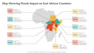
Map Showing Floods Impact On East African Countries
The map of East Africa unfolds a mesmerizing tapestry of diverse landscapes, cultures, and histories. This region, nestled on the eastern part of the continent, encompasses countries like Kenya, Tanzania, Uganda, Rwanda, Burundi, and South Sudan. The Great Rift Valley, a prominent geological feature, stretches across East Africa, defining its topography with highlands, rifts, and majestic lakes. From the iconic Mount Kilimanjaro in Tanzania, the tallest freestanding mountain globally, to the wildlife-rich plains of the Serengeti and Maasai Mara, East Africas physical features are both breathtaking and varied. The Indian Ocean coastline adds a coastal charm, enhancing the regions economic significance and facilitating trade and maritime activities. Culturally, East Africa is a mosaic of ethnicities, languages, and traditions. Swahili, a lingua franca, weaves through the coastal regions, fostering communication among diverse communities. The map of East Africa tells tales of ancient civilizations, vibrant indigenous cultures, and the impact of the Indian Ocean trade routes. In contemporary times, East Africa is a hub of economic activity and a sanctuary for biodiversity. As the map unfolds, it showcases a region of resilience, cooperation, and a shared commitment to both preserving its heritage and embracing the future
You must be logged in to download this presentation.
 Impress your
 audience
Editable
of Time
PowerPoint presentation slides
Presenting our set of slides with Map Showing Floods Impact On East African Countries. This exhibits information on one stages of the process. This is an easy to edit and innovatively designed PowerPoint template. So download immediately and highlight information on Political Map Of East Africa, Political Map Of Africa, East Africa On World Map, Regional Map Of East Africa.
Map Showing Floods Impact On East African Countries with all 10 slides:
Use our Map Showing Floods Impact On East African Countries to effectively help you save your valuable time. They are readymade to fit into any presentation structure.
-
I have been using SlideTeam for the past six months. Very happy and satisfied!
-
“One of the best experiences with SlideTeam for my presentation.Everything on time, communication is efficient and price is reasonable. All good in one place.”


